


Garmin MSC 10 Marine Satellite Compass Heading Sensor and Multi-band GPS Receiver (010-02407-10)
Garmin MSC 10 Marine Satellite Compass Heading Sensor and Multi-band GPS Receiver (010-02407-10)
SKU: 010-02407-10
Stock bas
 WhatsApp
 SMS - Text us!
 Email Us!
 Help Desk




Avis
Spécifications

Dans la boîte
Pole mount
Mounting hardware
NMEA 2000® backbone/drop cable (6 meters)
NMEA 2000 T-connector
Documentation
Vous avez un vieux GPS qui traîne ? Le programme Trade In and Up de GPS Nation est un excellent moyen d'échanger votre ancien GPS usagé contre un crédit pour l'achat d'un nouveau GPS. Le choix vous appartient entièrement ! Nous avons simplifié et rationalisé le processus. Suivez ces étapes simples et vous serez sur la bonne voie pour recevoir un crédit pour votre tout nouveau GPS !
1. Obtenez un devis
Pour obtenir votre devis gratuit, indiquez le type, le fabricant, le modèle et l'état de votre GPS. Dans les 24 heures, vous recevrez un devis correspondant à la valeur de reprise de votre produit actuel. Le formulaire de reprise/d'échange de GPS se trouve au bas de cette page.
2. Expédiez votre/vos produit(s) pour le commerce
Après avoir accepté notre offre, emballez votre ou vos produits en toute sécurité et expédiez-les-nous à l'aide de l'étiquette d'expédition prépayée qui vous a été fournie. Nous vous enverrons un e-mail de confirmation lorsque votre échange arrivera à notre entrepôt. Vous disposez de 30 jours à compter de la date à laquelle vous avez terminé votre échange en ligne pour expédier le produit à GPS Nation.
3. Effectuez votre achat
Une fois que nous aurons reçu votre produit à notre entrepôt et que nous aurons validé l'état indiqué, nous vous enverrons un e-mail de confirmation. Si vous choisissez de recevoir un crédit pour un nouveau GPS sur gpsnation.com, votre crédit de magasin sera émis et vous serez libre de procéder à votre achat.
Manuel et garantie
Avis
Poser une question
Spécifications
Dans la boîte
Pole mount
Mounting hardware
NMEA 2000® backbone/drop cable (6 meters)
NMEA 2000 T-connector
Documentation
Programme d'échange
Vous avez un vieux GPS qui traîne ? Le programme Trade In and Up de GPS Nation est un excellent moyen d'échanger votre ancien GPS usagé contre un crédit pour l'achat d'un nouveau GPS. Le choix vous appartient entièrement ! Nous avons simplifié et rationalisé le processus. Suivez ces étapes simples et vous serez sur la bonne voie pour recevoir un crédit pour votre tout nouveau GPS !
1. Obtenez un devis
Pour obtenir votre devis gratuit, indiquez le type, le fabricant, le modèle et l'état de votre GPS. Dans les 24 heures, vous recevrez un devis correspondant à la valeur de reprise de votre produit actuel. Le formulaire de reprise/d'échange de GPS se trouve au bas de cette page.
2. Expédiez votre/vos produit(s) pour le commerce
Après avoir accepté notre offre, emballez votre ou vos produits en toute sécurité et expédiez-les-nous à l'aide de l'étiquette d'expédition prépayée qui vous a été fournie. Nous vous enverrons un e-mail de confirmation lorsque votre échange arrivera à notre entrepôt. Vous disposez de 30 jours à compter de la date à laquelle vous avez terminé votre échange en ligne pour expédier le produit à GPS Nation.
3. Effectuez votre achat
Une fois que nous aurons reçu votre produit à notre entrepôt et que nous aurons validé l'état indiqué, nous vous enverrons un e-mail de confirmation. Si vous choisissez de recevoir un crédit pour un nouveau GPS sur gpsnation.com, votre crédit de magasin sera émis et vous serez libre de procéder à votre achat.
Manuel et garantie
Aperçu
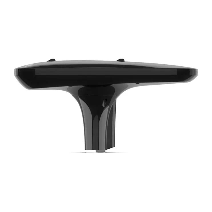
Garmin MSC 10 Marine Satellite Compass Heading Sensor and Multi-band GPS Receiver
Introduction
The Garmin MSC 10 combines satellite-based heading with multi-constellation GNSS positioning to eliminate the limitations of magnetic compasses on modern vessels. Unlike traditional magnetic sensors that struggle with interference and vessel acceleration, this integrated heading and positioning system delivers consistent accuracy across all speed ranges and sea conditions by calculating heading directly from satellite signals. With built-in motion sensing that continuously monitors pitch, roll, and heave, the MSC 10 provides the situational awareness needed for precision navigation, autopilot control, and real-time vessel tracking in calm waters and challenging offshore environments.
Key Features
- Multi-band GNSS receiver supporting GPS, Galileo, GLONASS, and BeiDou constellations for redundant satellite coverage
- L1 and L5 GPS signal reception for enhanced positioning accuracy and faster convergence in challenging environments
- Heading accuracy within 2 degrees using satellite signals instead of magnetic reference, eliminating magnetic interference issues
- Built-in Attitude Heading Reference System (AHRS) maintaining accurate heading while stationary, underway, and during sharp vessel maneuvers
- 10 Hz position update rate delivering responsive heading and movement tracking for smooth autopilot control and navigation displays
- Integrated boat motion monitoring measuring pitch, roll, and heave with real-time vessel attitude reporting to onboard systems
- NMEA 2000 network compatibility integrating directly with Garmin chartplotters, autopilots, and other marine electronics
- Automatic backup magnetometer-based heading providing continuous navigation data when satellite signals are temporarily unavailable
Data Insights
The MSC 10 achieves heading accuracy within 2 degrees using satellite geometry rather than magnetic orientation, solving the primary limitation of traditional marine compasses that degrade under electrical interference and accelerated vessel motion. Its 10 Hz update rate means position and heading data refresh 10 times per second, compared to standard 1 Hz systems, resulting in noticeably smoother autopilot tracking and more responsive course corrections. Multi-constellation support from four satellite systems provides redundancy that improves availability and reduces solution gaps in areas with limited line-of-sight to the sky.
Usage Instructions
Mount the Garmin MSC 10 in a location with unobstructed sky view according to the supplied installation guide and connect it to your vessel's NMEA 2000 network backbone. Configure it with your compatible Garmin chartplotter or autopilot to begin transmitting heading, positioning, and vessel motion data. If magnetic backup functionality is needed, perform the recommended magnetometer calibration during initial setup. Verify system operation regularly and maintain a clear overhead sky exposure for optimal satellite signal reception, particularly when navigating in channels or areas with tall buildings or tree coverage.
Design & Material
The MSC 10 features a streamlined, compact design engineered specifically for marine environments where space and simplicity are priorities. Its one-piece construction integrates multiple sensor functions that would otherwise require separate installations, reducing installation complexity and system redundancy while maintaining rugged weather resistance for continuous saltwater exposure.
- Compact form factor designed to fit marine mounting footprints with minimal deck or console space requirements
- Multi-band GNSS receiver circuitry supporting simultaneous reception of GPS, Galileo, GLONASS, and BeiDou signals
- Integrated Attitude Heading Reference System with internal motion sensors measuring pitch, roll, and heave continuously
- Backup magnetometer providing secondary heading calculation when primary GNSS-based heading is unavailable
- Rugged weather-resistant construction rated for marine salt spray and UV exposure on exposed boat structures
- NMEA 2000 network interface for direct integration with Garmin marine systems and compatible third-party electronics
- Compact antenna design optimized for satellite signal reception with 360-degree coverage pattern
Final Verdict
The Garmin MSC 10 Marine Satellite Compass is the precision heading and positioning solution for boaters and marine professionals who demand accuracy independent of magnetic interference. Its combination of multi-constellation GNSS positioning, 2-degree heading accuracy, 10 Hz update rates, and integrated vessel motion monitoring eliminates the compromises of magnetic compasses while delivering seamless integration into existing Garmin navigation ecosystems. Whether upgrading an autopilot system, enhancing chartplotter accuracy, or installing a complete navigation overhaul, the MSC 10 provides the reliable, responsive performance needed for confident coastal navigation, offshore voyaging, and demanding trolling applications. Make the upgrade to satellite-based heading and experience the precision difference on every outing.


