

Garmin Worldwide Coastal Charts BlueChart g3 HXWW001G microSD/SD (010-C1137-20)
Garmin Worldwide Coastal Charts BlueChart g3 HXWW001G microSD/SD (010-C1137-20)
SKU: 010-C1137-20
Stock bas
 WhatsApp
 SMS - Text us!
 Email Us!
 Help Desk
Avis
Spécifications
Garmin BlueChart g3 HXWW001G Worldwide Coastal Charts microSD/SD Card
Introduction
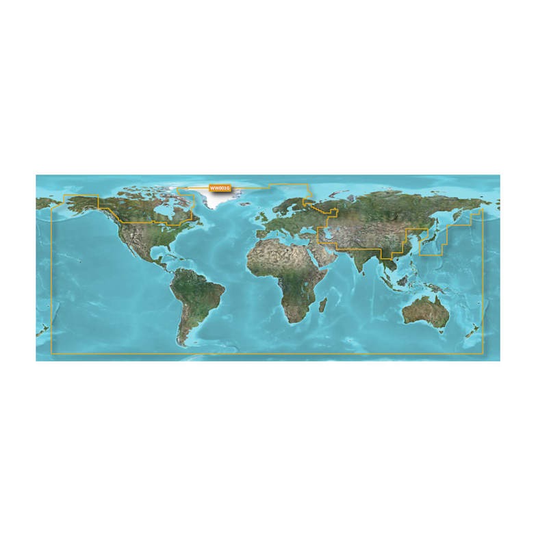
The Garmin BlueChart g3 HXWW001G Worldwide Coastal Charts microSD/SD card delivers comprehensive global coastal mapping data directly to your compatible Garmin chartplotter. This digital chart solution combines official hydrographic sources with trusted private data providers to create navigational tools that reduce guesswork and improve decision-making during every voyage. Whether you operate in home waters or explore unfamiliar coastlines, BlueChart g3 provides the marine-specific detail needed for safer harbor approaches, more efficient route planning, and better situational awareness across open water and confined passages alike.
Key Features
- Worldwide coastal chart coverage across all major ocean regions and navigable waterways
- Detailed depth contours and spot soundings for identifying channels, shoals, and underwater navigation hazards
- Tides and currents data integrated into chart display for current-aware voyage planning
- Shallow water shading with user-defined depth threshold settings for real-time hazard visualization
- Complete harbor and marina directory with approach details, anchorages, and facility information
- Comprehensive navigational aid display including buoys, lights, waypoints, and marine landmarks across all charted regions
Data Insights
BlueChart g3 addresses the critical navigation challenge of operating in unfamiliar waters by combining detailed depth mapping with real-time tidal and current information. The shallow water shading feature allows you to establish custom depth thresholds that visually highlight zones matching your vessel's draft, significantly improving hazard awareness in coastal and nearshore environments. Access to official harbor data eliminates the trial-and-error approach to port entry, while spot soundings and contour detail provide the underwater picture needed to understand why particular routes offer safer passage than others.
Usage Instructions
Insert the microSD/SD card into your compatible Garmin chartplotter's memory card slot following your device manual. Once recognized, navigate to chart settings within the chartplotter menu to customize display options including depth shading ranges, chart overlays, and information layers. Use the included chart data during pre-voyage route planning to identify hazards and plan efficient passages, monitor depth and navigation aids during operation, and reference harbor approaches and marina locations when entering unfamiliar ports. Always verify navigation information against current official sources and follow safe boating practices appropriate to your vessel and operating environment.
Design & Material
The BlueChart g3 HXWW001G ships as a compact microSD/SD memory card engineered for plug-and-play compatibility with Garmin's marine chartplotter ecosystem. The format provides instant access to advanced mapping features without requiring software installation or configuration beyond basic menu adjustments on your chartplotter display.
- microSD/SD memory card form factor for straightforward installation in any compatible Garmin chartplotter
- Chart data derived from official international hydrographic sources and established private marine data providers
- Detailed cartography including bottom composition, wrecks, underwater structures, and hazard markers
- Integrated tidal station information and current prediction data where available across charted regions
- Marina and harbor database with facility amenities, services, approach routes, and anchorage details
- Customizable shallow water shading that highlights user-selected depth ranges for enhanced hazard awareness
Final Verdict
The Garmin BlueChart g3 HXWW001G is the navigation solution for boaters who demand reliable, detailed marine chart information across global waters. By combining official hydrographic data with tidal information, depth detail, and comprehensive harbor knowledge, it transforms your Garmin chartplotter into a fully capable offshore and coastal navigation system. If you cruise beyond home waters, operate in unfamiliar regions, or prioritize navigation confidence and route efficiency, this chart card provides the essential information depth and coverage your boating demands. Order your BlueChart g3 HXWW001G today to access worldwide coastal navigation at your fingertips.
Dans la boîte
Vous avez un vieux GPS qui traîne ? Le programme Trade In and Up de GPS Nation est un excellent moyen d'échanger votre ancien GPS usagé contre un crédit pour l'achat d'un nouveau GPS. Le choix vous appartient entièrement ! Nous avons simplifié et rationalisé le processus. Suivez ces étapes simples et vous serez sur la bonne voie pour recevoir un crédit pour votre tout nouveau GPS !
1. Obtenez un devis
Pour obtenir votre devis gratuit, indiquez le type, le fabricant, le modèle et l'état de votre GPS. Dans les 24 heures, vous recevrez un devis correspondant à la valeur de reprise de votre produit actuel. Le formulaire de reprise/d'échange de GPS se trouve au bas de cette page.
2. Expédiez votre/vos produit(s) pour le commerce
Après avoir accepté notre offre, emballez votre ou vos produits en toute sécurité et expédiez-les-nous à l'aide de l'étiquette d'expédition prépayée qui vous a été fournie. Nous vous enverrons un e-mail de confirmation lorsque votre échange arrivera à notre entrepôt. Vous disposez de 30 jours à compter de la date à laquelle vous avez terminé votre échange en ligne pour expédier le produit à GPS Nation.
3. Effectuez votre achat
Une fois que nous aurons reçu votre produit à notre entrepôt et que nous aurons validé l'état indiqué, nous vous enverrons un e-mail de confirmation. Si vous choisissez de recevoir un crédit pour un nouveau GPS sur gpsnation.com, votre crédit de magasin sera émis et vous serez libre de procéder à votre achat.
Manuel et garantie
Avis
Poser une question
Spécifications
Garmin BlueChart g3 HXWW001G Worldwide Coastal Charts microSD/SD Card
Introduction
The Garmin BlueChart g3 HXWW001G Worldwide Coastal Charts microSD/SD card delivers comprehensive global coastal mapping data directly to your compatible Garmin chartplotter. This digital chart solution combines official hydrographic sources with trusted private data providers to create navigational tools that reduce guesswork and improve decision-making during every voyage. Whether you operate in home waters or explore unfamiliar coastlines, BlueChart g3 provides the marine-specific detail needed for safer harbor approaches, more efficient route planning, and better situational awareness across open water and confined passages alike.
Key Features
- Worldwide coastal chart coverage across all major ocean regions and navigable waterways
- Detailed depth contours and spot soundings for identifying channels, shoals, and underwater navigation hazards
- Tides and currents data integrated into chart display for current-aware voyage planning
- Shallow water shading with user-defined depth threshold settings for real-time hazard visualization
- Complete harbor and marina directory with approach details, anchorages, and facility information
- Comprehensive navigational aid display including buoys, lights, waypoints, and marine landmarks across all charted regions
Data Insights
BlueChart g3 addresses the critical navigation challenge of operating in unfamiliar waters by combining detailed depth mapping with real-time tidal and current information. The shallow water shading feature allows you to establish custom depth thresholds that visually highlight zones matching your vessel's draft, significantly improving hazard awareness in coastal and nearshore environments. Access to official harbor data eliminates the trial-and-error approach to port entry, while spot soundings and contour detail provide the underwater picture needed to understand why particular routes offer safer passage than others.
Usage Instructions
Insert the microSD/SD card into your compatible Garmin chartplotter's memory card slot following your device manual. Once recognized, navigate to chart settings within the chartplotter menu to customize display options including depth shading ranges, chart overlays, and information layers. Use the included chart data during pre-voyage route planning to identify hazards and plan efficient passages, monitor depth and navigation aids during operation, and reference harbor approaches and marina locations when entering unfamiliar ports. Always verify navigation information against current official sources and follow safe boating practices appropriate to your vessel and operating environment.
Design & Material
The BlueChart g3 HXWW001G ships as a compact microSD/SD memory card engineered for plug-and-play compatibility with Garmin's marine chartplotter ecosystem. The format provides instant access to advanced mapping features without requiring software installation or configuration beyond basic menu adjustments on your chartplotter display.
- microSD/SD memory card form factor for straightforward installation in any compatible Garmin chartplotter
- Chart data derived from official international hydrographic sources and established private marine data providers
- Detailed cartography including bottom composition, wrecks, underwater structures, and hazard markers
- Integrated tidal station information and current prediction data where available across charted regions
- Marina and harbor database with facility amenities, services, approach routes, and anchorage details
- Customizable shallow water shading that highlights user-selected depth ranges for enhanced hazard awareness
Final Verdict
The Garmin BlueChart g3 HXWW001G is the navigation solution for boaters who demand reliable, detailed marine chart information across global waters. By combining official hydrographic data with tidal information, depth detail, and comprehensive harbor knowledge, it transforms your Garmin chartplotter into a fully capable offshore and coastal navigation system. If you cruise beyond home waters, operate in unfamiliar regions, or prioritize navigation confidence and route efficiency, this chart card provides the essential information depth and coverage your boating demands. Order your BlueChart g3 HXWW001G today to access worldwide coastal navigation at your fingertips.
Dans la boîte
Programme d'échange
Vous avez un vieux GPS qui traîne ? Le programme Trade In and Up de GPS Nation est un excellent moyen d'échanger votre ancien GPS usagé contre un crédit pour l'achat d'un nouveau GPS. Le choix vous appartient entièrement ! Nous avons simplifié et rationalisé le processus. Suivez ces étapes simples et vous serez sur la bonne voie pour recevoir un crédit pour votre tout nouveau GPS !
1. Obtenez un devis
Pour obtenir votre devis gratuit, indiquez le type, le fabricant, le modèle et l'état de votre GPS. Dans les 24 heures, vous recevrez un devis correspondant à la valeur de reprise de votre produit actuel. Le formulaire de reprise/d'échange de GPS se trouve au bas de cette page.
2. Expédiez votre/vos produit(s) pour le commerce
Après avoir accepté notre offre, emballez votre ou vos produits en toute sécurité et expédiez-les-nous à l'aide de l'étiquette d'expédition prépayée qui vous a été fournie. Nous vous enverrons un e-mail de confirmation lorsque votre échange arrivera à notre entrepôt. Vous disposez de 30 jours à compter de la date à laquelle vous avez terminé votre échange en ligne pour expédier le produit à GPS Nation.
3. Effectuez votre achat
Une fois que nous aurons reçu votre produit à notre entrepôt et que nous aurons validé l'état indiqué, nous vous enverrons un e-mail de confirmation. Si vous choisissez de recevoir un crédit pour un nouveau GPS sur gpsnation.com, votre crédit de magasin sera émis et vous serez libre de procéder à votre achat.
Manuel et garantie
Aperçu
Garmin BlueChart g3 HXWW001G Worldwide Coastal Charts microSD/SD Card
Introduction
The Garmin BlueChart g3 HXWW001G Worldwide Coastal Charts microSD/SD card delivers comprehensive global coastal mapping data directly to your compatible Garmin chartplotter. This digital chart solution combines official hydrographic sources with trusted private data providers to create navigational tools that reduce guesswork and improve decision-making during every voyage. Whether you operate in home waters or explore unfamiliar coastlines, BlueChart g3 provides the marine-specific detail needed for safer harbor approaches, more efficient route planning, and better situational awareness across open water and confined passages alike.
Key Features
- Worldwide coastal chart coverage across all major ocean regions and navigable waterways
- Detailed depth contours and spot soundings for identifying channels, shoals, and underwater navigation hazards
- Tides and currents data integrated into chart display for current-aware voyage planning
- Shallow water shading with user-defined depth threshold settings for real-time hazard visualization
- Complete harbor and marina directory with approach details, anchorages, and facility information
- Comprehensive navigational aid display including buoys, lights, waypoints, and marine landmarks across all charted regions
Data Insights
BlueChart g3 addresses the critical navigation challenge of operating in unfamiliar waters by combining detailed depth mapping with real-time tidal and current information. The shallow water shading feature allows you to establish custom depth thresholds that visually highlight zones matching your vessel's draft, significantly improving hazard awareness in coastal and nearshore environments. Access to official harbor data eliminates the trial-and-error approach to port entry, while spot soundings and contour detail provide the underwater picture needed to understand why particular routes offer safer passage than others.
Usage Instructions
Insert the microSD/SD card into your compatible Garmin chartplotter's memory card slot following your device manual. Once recognized, navigate to chart settings within the chartplotter menu to customize display options including depth shading ranges, chart overlays, and information layers. Use the included chart data during pre-voyage route planning to identify hazards and plan efficient passages, monitor depth and navigation aids during operation, and reference harbor approaches and marina locations when entering unfamiliar ports. Always verify navigation information against current official sources and follow safe boating practices appropriate to your vessel and operating environment.
Design & Material
The BlueChart g3 HXWW001G ships as a compact microSD/SD memory card engineered for plug-and-play compatibility with Garmin's marine chartplotter ecosystem. The format provides instant access to advanced mapping features without requiring software installation or configuration beyond basic menu adjustments on your chartplotter display.
- microSD/SD memory card form factor for straightforward installation in any compatible Garmin chartplotter
- Chart data derived from official international hydrographic sources and established private marine data providers
- Detailed cartography including bottom composition, wrecks, underwater structures, and hazard markers
- Integrated tidal station information and current prediction data where available across charted regions
- Marina and harbor database with facility amenities, services, approach routes, and anchorage details
- Customizable shallow water shading that highlights user-selected depth ranges for enhanced hazard awareness
Final Verdict
The Garmin BlueChart g3 HXWW001G is the navigation solution for boaters who demand reliable, detailed marine chart information across global waters. By combining official hydrographic data with tidal information, depth detail, and comprehensive harbor knowledge, it transforms your Garmin chartplotter into a fully capable offshore and coastal navigation system. If you cruise beyond home waters, operate in unfamiliar regions, or prioritize navigation confidence and route efficiency, this chart card provides the essential information depth and coverage your boating demands. Order your BlueChart g3 HXWW001G today to access worldwide coastal navigation at your fingertips.


