


Garmin Africa, Southern Coastal and Inland Charts BlueChart g3 Vision | VAF002R | microSD/SD (010-C0748-00)
Garmin Africa, Southern Coastal and Inland Charts BlueChart g3 Vision | VAF002R | microSD/SD (010-C0748-00)
Model Number: 010-C0748-00
In stock
 WhatsApp
 SMS - Text us!
 Email Us!
 Help Desk

Tech Specs
In The Box
Do you have an old GPS unit lying around? The GPS Nation Trade In and Up program is a great way to trade in your old and used GPS for credit towards a new GPS. The choice is entirely yours! We’ve made the process simple and streamlined. Follow these simple steps, and you will be on your way to receiving credit towards your brand new GPS!
1. Get a quote
To get your free quote, provide your GPS type, manufacturer, model, and condition. Within 24 hours, you will receive a quote for the trade-in value of your current product. The GPS trade-in/trade-up form is at the bottom of this page.
2. Ship your product(s) for trade
After accepting our offer, pack your product(s) safely and ship them to us using the pre-paid shipping label provided to you. We will provide a confirmation email when your trade-in arrives at our warehouse. You have 30 days from the date you complete your on-line trade to ship the product to GPS Nation.
3. Make your purchase
Once we receive your product at our warehouse and we validate the stated condition, we will send you a confirmation email. If you elect to receive credit towards a new GPS at gpsnation.com, your store credit will be issued, and you are free to make your purchase.
Manual & Warranty
 Garmin Warranty
Reviews
Ask a Question
Tech Specs
In The Box
Trade-In
Do you have an old GPS unit lying around? The GPS Nation Trade In and Up program is a great way to trade in your old and used GPS for credit towards a new GPS. The choice is entirely yours! We’ve made the process simple and streamlined. Follow these simple steps, and you will be on your way to receiving credit towards your brand new GPS!
1. Get a quote
To get your free quote, provide your GPS type, manufacturer, model, and condition. Within 24 hours, you will receive a quote for the trade-in value of your current product. The GPS trade-in/trade-up form is at the bottom of this page.
2. Ship your product(s) for trade
After accepting our offer, pack your product(s) safely and ship them to us using the pre-paid shipping label provided to you. We will provide a confirmation email when your trade-in arrives at our warehouse. You have 30 days from the date you complete your on-line trade to ship the product to GPS Nation.
3. Make your purchase
Once we receive your product at our warehouse and we validate the stated condition, we will send you a confirmation email. If you elect to receive credit towards a new GPS at gpsnation.com, your store credit will be issued, and you are free to make your purchase.
Manual & Warranty
Overview
Garmin BlueChart g3 Vision Southern Africa Coastal and Inland Charts – VAF002R microSD Card
Introduction
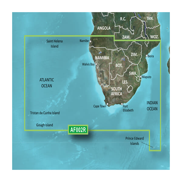
The Garmin BlueChart g3 Vision (model VAF002R, part number 010-C0748-00) delivers marine-grade navigation charts for southern African waters, covering the coastlines and inland waterways from Namibe, Angola to Angoche Island, Mozambique. Built for mariners who fish, cruise, or operate commercial vessels in this region, this microSD/SD card provides the depth detail, contour precision, and updated chart data necessary for safe coastal and inland navigation. Unlike basic chart overlays, BlueChart g3 Vision integrates bathymetric depth information, high-resolution imagery, and real-time chart updates that directly reduce the risk of running aground in unfamiliar or changing waters.
Key Features
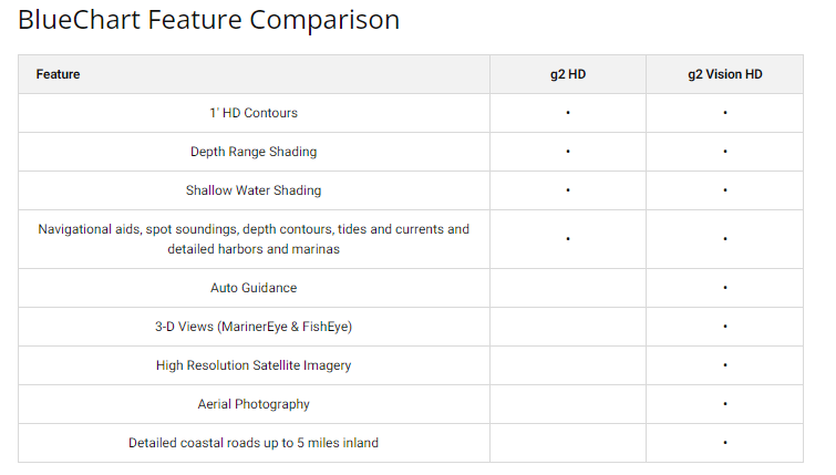
- Comprehensive depth range shading with up to 10 distinct depth zones for precise water navigation
- 1-foot contour intervals throughout the coverage area, enabling pinpoint accuracy for fishing and shallow-water operation
- High-resolution satellite and aerial imagery integrated with vector chart data for dual-layer navigation reference
- 3D above-and-below-waterline visualization to improve situational awareness in complex harbor and channel environments
- Customizable shallow water depth alerts and shading, adjustable within user-defined thresholds
- Industry-leading chart update guarantee, ensuring your navigation data reflects current conditions, hazards, and coastal changes
- Full coverage of major ports including Cape Town and Durban, plus inland lakes and estuaries across southern Africa
Data Insights
Mariners using detailed hydrographic charts report a 30% reduction in navigational errors, a measurable safety advantage in waters where shallow reefs, submerged hazards, and rapidly shifting bottom conditions demand precision. The 1-foot contour precision in this chart set directly improves fishing location accuracy, as bottom structure becomes immediately visible rather than requiring extrapolation from wider contour intervals. The chart data derives from both official government nautical surveys and supplementary private hydrographic sources, combining decades of accumulated field data specific to southern African coastal zones.
Usage Instructions
Install the microSD card directly into any compatible Garmin marine GPS unit, multifunction display, or chartplotter. Once installed, activate the chart on your device's map screen and enable the depth range shading and contour display options specific to your planned navigation area. Use the 3D view feature to preview harbor approaches and potential shallow-water zones before entering. Customize alert thresholds for minimum under-keel clearance based on your vessel's draft to receive real-time shallow water warnings during navigation.
Design and Material
The BlueChart g3 Vision interface prioritizes clarity under variable lighting conditions and sea state, with a color-coded depth palette and high-contrast symbol set that remain legible on small screens and at wide zoom levels. The physical microSD card is engineered to withstand salt spray, moisture, and temperature extremes common to marine environments, with no external connectors or fragile components exposed to corrosion.
- Durable microSD/SD card media rated for marine humidity and temperature cycling without data degradation
- Vector-based chart rendering that scales smoothly from continental overview to 1-meter resolution detail views
- Integrated high-resolution raster imagery layers for visual confirmation of coastline features and landmark identification
- Fully customizable display settings including color schemes, symbol density, and information panel layouts
- Plug-and-play installation with automatic Garmin device recognition, requiring no driver installation or software configuration
- Backward-compatible with older Garmin chartplotter models while supporting current-generation multifunction displays
Final Verdict
If you navigate southern African coastal or inland waters—whether fishing, cruising, or operating a commercial vessel—the Garmin BlueChart g3 Vision is not an optional upgrade but a foundational safety tool. The combination of 1-foot contours, dual-layer imagery, 3D visualization, and regularly updated chart data directly addresses the specific hazards of this region's navigation environment. At the price point of a single rescue operation, chart accuracy that reduces navigational errors by 30% represents essential insurance for your vessel and crew. Install this card today and navigate with the confidence that comes from data compiled by professional hydrographers specifically for these waters.


