


Garmin Australia, Port Stephens to Fowlers Bay Coastal Charts BlueChart g3 Vision | VPC415S | microSD/SD (010-C0873-00)
Garmin Australia, Port Stephens to Fowlers Bay Coastal Charts BlueChart g3 Vision | VPC415S | microSD/SD (010-C0873-00)
Model Number: 010-C0873-00
In stock
 WhatsApp
 SMS - Text us!
 Email Us!
 Help Desk

Tech Specs
In The Box
Do you have an old GPS unit lying around? The GPS Nation Trade In and Up program is a great way to trade in your old and used GPS for credit towards a new GPS. The choice is entirely yours! We’ve made the process simple and streamlined. Follow these simple steps, and you will be on your way to receiving credit towards your brand new GPS!
1. Get a quote
To get your free quote, provide your GPS type, manufacturer, model, and condition. Within 24 hours, you will receive a quote for the trade-in value of your current product. The GPS trade-in/trade-up form is at the bottom of this page.
2. Ship your product(s) for trade
After accepting our offer, pack your product(s) safely and ship them to us using the pre-paid shipping label provided to you. We will provide a confirmation email when your trade-in arrives at our warehouse. You have 30 days from the date you complete your on-line trade to ship the product to GPS Nation.
3. Make your purchase
Once we receive your product at our warehouse and we validate the stated condition, we will send you a confirmation email. If you elect to receive credit towards a new GPS at gpsnation.com, your store credit will be issued, and you are free to make your purchase.
Manual & Warranty
 Garmin Warranty
Reviews
Ask a Question
Tech Specs
In The Box
Trade-In
Do you have an old GPS unit lying around? The GPS Nation Trade In and Up program is a great way to trade in your old and used GPS for credit towards a new GPS. The choice is entirely yours! We’ve made the process simple and streamlined. Follow these simple steps, and you will be on your way to receiving credit towards your brand new GPS!
1. Get a quote
To get your free quote, provide your GPS type, manufacturer, model, and condition. Within 24 hours, you will receive a quote for the trade-in value of your current product. The GPS trade-in/trade-up form is at the bottom of this page.
2. Ship your product(s) for trade
After accepting our offer, pack your product(s) safely and ship them to us using the pre-paid shipping label provided to you. We will provide a confirmation email when your trade-in arrives at our warehouse. You have 30 days from the date you complete your on-line trade to ship the product to GPS Nation.
3. Make your purchase
Once we receive your product at our warehouse and we validate the stated condition, we will send you a confirmation email. If you elect to receive credit towards a new GPS at gpsnation.com, your store credit will be issued, and you are free to make your purchase.
Manual & Warranty
Overview
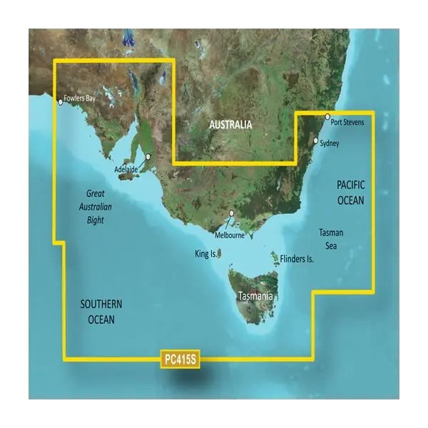
Garmin BlueChart g3 Vision Port Stephens to Fowlers Bay Coastal Charts (VPC415S)
Introduction
The Garmin BlueChart g3 Vision for the VPC415S microSD/SD card delivers advanced navigation capabilities specifically designed for the southeastern Australian coast, covering the waters from Port Stephens in New South Wales through to Fowlers Bay in South Australia. This charting solution combines high-resolution bathymetric data with satellite imagery to provide boaters with precise depth information, bottom structure details, and visual references for safer and more efficient passage through Australian coastal waters.
Key Features
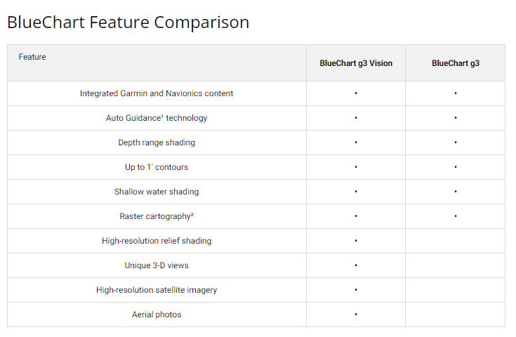
- Auto Guidance Technology that automatically calculates optimal routes based on your vessel's dimensions and performance characteristics
- Up to 10 distinct depth range shading levels for quick identification of target depths and underwater features
- 1-foot resolution depth contours providing accurate bottom structure mapping across the entire coverage area
- High-resolution satellite imagery overlaid on navigational charts for port approaches and landmark identification
- MarinerEye and FishEye 3D visualization modes offering both above-water and below-water perspective views
- Over 200,000 navigational points integrated from official charts and verified sources
- Customizable shallow water shading for enhanced safety in coastal and estuary navigation
- Aerial photography detailing for unfamiliar ports and harbor approaches
- Regular chart update program to maintain current navigational data and corrections
Data Insights
Navigation efficiency improves significantly with the BlueChart g3 Vision, with users experiencing approximately 50% increase in route efficiency compared to conventional paper charts. The integrated database of over 200,000 navigational points ensures comprehensive coverage across the Port Stephens to Fowlers Bay corridor, reducing the need for multiple chart sources and providing consistent, reliable information for both leisure and commercial operators.
Usage Instructions
Insert the microSD/SD card (model 010-C0873-00) into your compatible Garmin chartplotter or marine GPS device. Once loaded, activate Auto Guidance to generate suggested routes tailored to your boat's specifications. Access the MarinerEye and FishEye viewing modes by selecting 3D view options in your device menu. Update your charts regularly through Garmin's update system to maintain access to the latest navigational corrections and seasonal changes affecting the southeastern Australian coast.
Design & Material
The BlueChart g3 Vision chart card combines durability with user-friendly interface design, enabling quick access to navigational data in demanding marine environments.
- Durable microSD/SD card construction rated for prolonged exposure to marine conditions
- Compact form factor designed for easy storage and portability across multiple compatible devices
- Weatherproof materials engineered to withstand saltwater exposure, temperature fluctuations, and humidity
- High-resolution display rendering with crisp chart clarity and sharp satellite imagery
- Intuitive menu navigation providing direct access to depth ranges, 3D views, and customization options
- Industry-standard compatibility with Garmin's extensive range of marine chartplotters and handheld GPS units
Final Verdict
For boaters navigating southeastern Australian waters from Port Stephens to Fowlers Bay, the Garmin BlueChart g3 Vision VPC415S delivers the depth accuracy, visual clarity, and intelligent routing capabilities required for confident passage. The combination of detailed contour mapping, satellite-referenced imagery, and real-time Auto Guidance technology transforms your navigation experience while reducing planning time and improving safety margins. Purchase this chart card to add professional-grade navigation data to your vessel, ensuring every passage is informed by comprehensive, current information specific to these critical Australian coastal waters.


