


Garmin Bluechart G2 Vision Norfolk-Charleston (010-C0708-00)
Garmin Bluechart G2 Vision Norfolk-Charleston (010-C0708-00)
Model Number: 010-C0708-00
In stock
 View full details
 WhatsApp
 SMS - Text us!
 Email Us!
 Help Desk


Tech Specs
Garmin Bluechart G2 Vision Norfolk-Charleston (010-C0708-00)
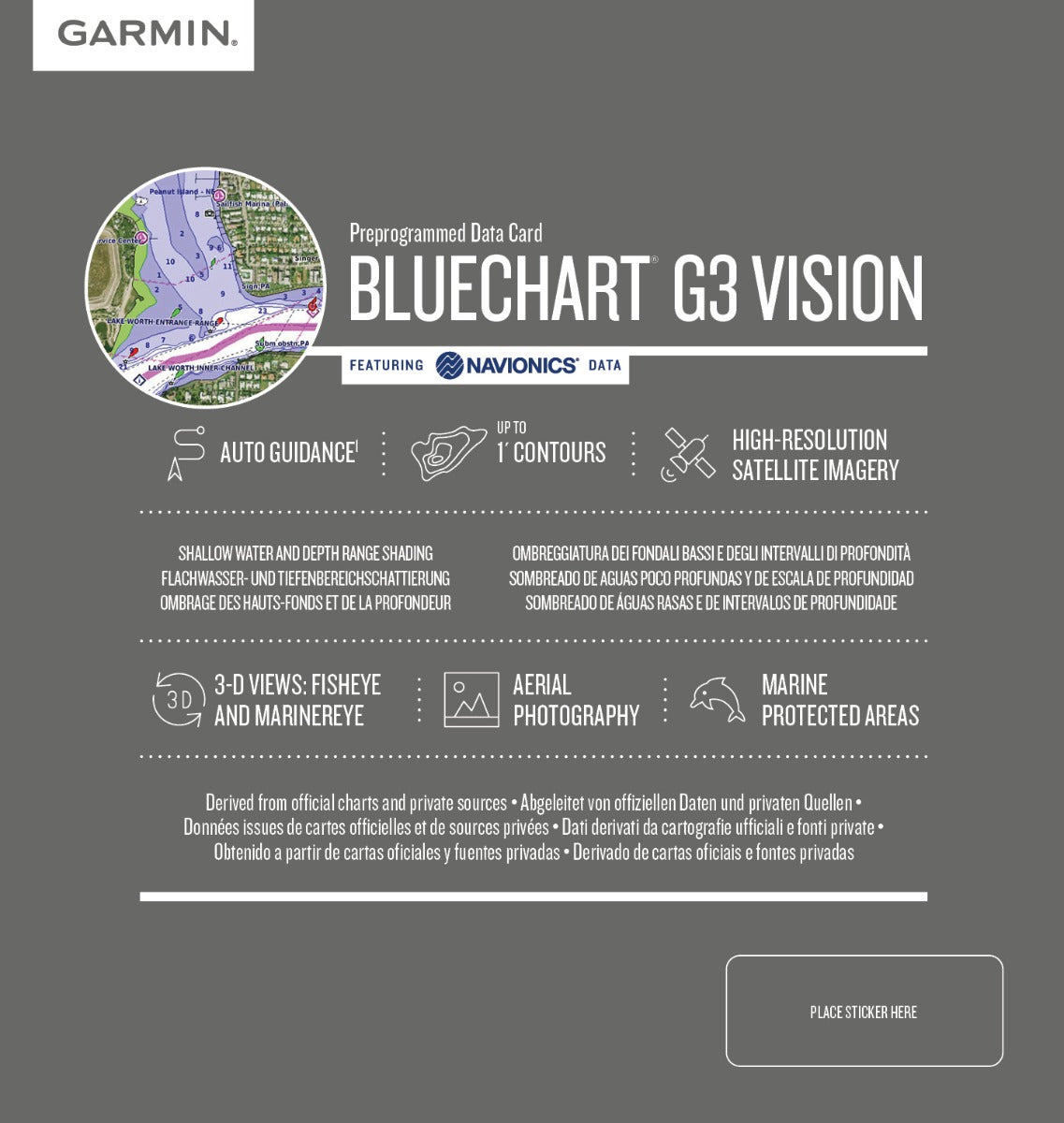
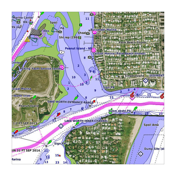
Experience marine navigation like never before with the Garmin Bluechart G2 Vision Norfolk-Charleston (010-C0708-00). This premium mapping software is tailored for boaters and navigators who prioritize precision and detail in their maritime adventures. Covering vital coastal areas from Newport News, VA to Charleston, SC, including significant waterways such as Pamlico Sound and Cape Lookout, this software enhances your boating experience by providing comprehensive and actionable data.
Key Features
- Shaded Depth Contours: Enhanced visual representation for better depth comprehension.
- High-Resolution Satellite Imagery: Realistic views of land and water to facilitate navigation.
- 3-D Perspectives: MarinerEye view for position fixing and FishEye view for underwater insights.
- Auto Guidance Technology: Automatically suggests optimal routes, analyzing chart data.
- Safety Shading: Customize shading for depths shallower than your defined limits, enhancing safety.
- Fishing Charts: Simplifies fishing expeditions by focusing on bottom contours and depth soundings.
Data Insights
With Garmin's advanced mapping technology, the Bluechart G2 Vision Norfolk-Charleston achieves an impressive accuracy rate of ±1 meter in coastal navigation. This precision allows for safer and more efficient journey planning, with detailed information on coastlines, soundings, and navigational aids, making it an essential tool for both recreational and professional mariners.
Usage Instructions
To maximize the benefits of your Garmin Bluechart G2 Vision, simply insert the data card into your compatible Garmin device. Utilize the Auto Guidance feature for optimal routing, and regularly update your software to ensure access to the latest marine data and enhancements.
Design & Material
The Garmin Bluechart G2 Vision is not only functional but also designed for user convenience. The software features a user-friendly interface that integrates seamlessly with Garmin devices.
- Durable Design: Engineered to withstand marine conditions.
- Intuitive Interface: Easy navigation through various features and settings.
- Comprehensive Coverage: Detailed maps spanning significant coastal areas.
- Advanced Technology: Integrates cutting-edge mapping technologies.
- Efficient Data Management: Designed for quick access to essential navigation details.
- Regular Updates: Ensure your maps are always current with the latest data.
Final Verdict
Elevate your boating adventures with the Garmin Bluechart G2 Vision Norfolk-Charleston (010-C0708-00). This state-of-the-art mapping software offers unmatched detail and advanced features that cater to serious navigators. Don't compromise on safety and efficiency—enhance your maritime experience today!
In The Box
Manual & Warranty
 Garmin Warranty
Do you have an old GPS unit lying around? The GPS Nation Trade In and Up program is a great way to trade in your old and used GPS for credit towards a new GPS. The choice is entirely yours! We’ve made the process simple and streamlined. Follow these simple steps, and you will be on your way to receiving credit towards your brand new GPS!
1. Get a quote
To get your free quote, provide your GPS type, manufacturer, model, and condition. Within 24 hours, you will receive a quote for the trade-in value of your current product. The GPS trade-in/trade-up form is at the bottom of this page.
2. Ship your product(s) for trade
After accepting our offer, pack your product(s) safely and ship them to us using the pre-paid shipping label provided to you. We will provide a confirmation email when your trade-in arrives at our warehouse. You have 30 days from the date you complete your on-line trade to ship the product to GPS Nation.
3. Make your purchase
Once we receive your product at our warehouse and we validate the stated condition, we will send you a confirmation email. If you elect to receive credit towards a new GPS at gpsnation.com, your store credit will be issued, and you are free to make your purchase.
Reviews
Ask a Question
Tech Specs
Garmin Bluechart G2 Vision Norfolk-Charleston (010-C0708-00)
Experience marine navigation like never before with the Garmin Bluechart G2 Vision Norfolk-Charleston (010-C0708-00). This premium mapping software is tailored for boaters and navigators who prioritize precision and detail in their maritime adventures. Covering vital coastal areas from Newport News, VA to Charleston, SC, including significant waterways such as Pamlico Sound and Cape Lookout, this software enhances your boating experience by providing comprehensive and actionable data.
Key Features
- Shaded Depth Contours: Enhanced visual representation for better depth comprehension.
- High-Resolution Satellite Imagery: Realistic views of land and water to facilitate navigation.
- 3-D Perspectives: MarinerEye view for position fixing and FishEye view for underwater insights.
- Auto Guidance Technology: Automatically suggests optimal routes, analyzing chart data.
- Safety Shading: Customize shading for depths shallower than your defined limits, enhancing safety.
- Fishing Charts: Simplifies fishing expeditions by focusing on bottom contours and depth soundings.
Data Insights
With Garmin's advanced mapping technology, the Bluechart G2 Vision Norfolk-Charleston achieves an impressive accuracy rate of ±1 meter in coastal navigation. This precision allows for safer and more efficient journey planning, with detailed information on coastlines, soundings, and navigational aids, making it an essential tool for both recreational and professional mariners.
Usage Instructions
To maximize the benefits of your Garmin Bluechart G2 Vision, simply insert the data card into your compatible Garmin device. Utilize the Auto Guidance feature for optimal routing, and regularly update your software to ensure access to the latest marine data and enhancements.
Design & Material
The Garmin Bluechart G2 Vision is not only functional but also designed for user convenience. The software features a user-friendly interface that integrates seamlessly with Garmin devices.
- Durable Design: Engineered to withstand marine conditions.
- Intuitive Interface: Easy navigation through various features and settings.
- Comprehensive Coverage: Detailed maps spanning significant coastal areas.
- Advanced Technology: Integrates cutting-edge mapping technologies.
- Efficient Data Management: Designed for quick access to essential navigation details.
- Regular Updates: Ensure your maps are always current with the latest data.
Final Verdict
Elevate your boating adventures with the Garmin Bluechart G2 Vision Norfolk-Charleston (010-C0708-00). This state-of-the-art mapping software offers unmatched detail and advanced features that cater to serious navigators. Don't compromise on safety and efficiency—enhance your maritime experience today!
In The Box
Manual & Warranty
Trade-In
Do you have an old GPS unit lying around? The GPS Nation Trade In and Up program is a great way to trade in your old and used GPS for credit towards a new GPS. The choice is entirely yours! We’ve made the process simple and streamlined. Follow these simple steps, and you will be on your way to receiving credit towards your brand new GPS!
1. Get a quote
To get your free quote, provide your GPS type, manufacturer, model, and condition. Within 24 hours, you will receive a quote for the trade-in value of your current product. The GPS trade-in/trade-up form is at the bottom of this page.
2. Ship your product(s) for trade
After accepting our offer, pack your product(s) safely and ship them to us using the pre-paid shipping label provided to you. We will provide a confirmation email when your trade-in arrives at our warehouse. You have 30 days from the date you complete your on-line trade to ship the product to GPS Nation.
3. Make your purchase
Once we receive your product at our warehouse and we validate the stated condition, we will send you a confirmation email. If you elect to receive credit towards a new GPS at gpsnation.com, your store credit will be issued, and you are free to make your purchase.
Overview
Garmin Bluechart G2 Vision Norfolk-Charleston (010-C0708-00)
Experience marine navigation like never before with the Garmin Bluechart G2 Vision Norfolk-Charleston (010-C0708-00). This premium mapping software is tailored for boaters and navigators who prioritize precision and detail in their maritime adventures. Covering vital coastal areas from Newport News, VA to Charleston, SC, including significant waterways such as Pamlico Sound and Cape Lookout, this software enhances your boating experience by providing comprehensive and actionable data.
Key Features
- Shaded Depth Contours: Enhanced visual representation for better depth comprehension.
- High-Resolution Satellite Imagery: Realistic views of land and water to facilitate navigation.
- 3-D Perspectives: MarinerEye view for position fixing and FishEye view for underwater insights.
- Auto Guidance Technology: Automatically suggests optimal routes, analyzing chart data.
- Safety Shading: Customize shading for depths shallower than your defined limits, enhancing safety.
- Fishing Charts: Simplifies fishing expeditions by focusing on bottom contours and depth soundings.
Data Insights
With Garmin's advanced mapping technology, the Bluechart G2 Vision Norfolk-Charleston achieves an impressive accuracy rate of ±1 meter in coastal navigation. This precision allows for safer and more efficient journey planning, with detailed information on coastlines, soundings, and navigational aids, making it an essential tool for both recreational and professional mariners.
Usage Instructions
To maximize the benefits of your Garmin Bluechart G2 Vision, simply insert the data card into your compatible Garmin device. Utilize the Auto Guidance feature for optimal routing, and regularly update your software to ensure access to the latest marine data and enhancements.
Design & Material
The Garmin Bluechart G2 Vision is not only functional but also designed for user convenience. The software features a user-friendly interface that integrates seamlessly with Garmin devices.
- Durable Design: Engineered to withstand marine conditions.
- Intuitive Interface: Easy navigation through various features and settings.
- Comprehensive Coverage: Detailed maps spanning significant coastal areas.
- Advanced Technology: Integrates cutting-edge mapping technologies.
- Efficient Data Management: Designed for quick access to essential navigation details.
- Regular Updates: Ensure your maps are always current with the latest data.
Final Verdict
Elevate your boating adventures with the Garmin Bluechart G2 Vision Norfolk-Charleston (010-C0708-00). This state-of-the-art mapping software offers unmatched detail and advanced features that cater to serious navigators. Don't compromise on safety and efficiency—enhance your maritime experience today!


