


Garmin Canada, Puget Sound to Dixon Entrance Charts BlueChart g3 Vision | VCA501L | microSD/SD (010-C0701-00)
Garmin Canada, Puget Sound to Dixon Entrance Charts BlueChart g3 Vision | VCA501L | microSD/SD (010-C0701-00)
Model Number: 010-C0701-00
In stock
 WhatsApp
 SMS - Text us!
 Email Us!
 Help Desk

Tech Specs
In The Box
Do you have an old GPS unit lying around? The GPS Nation Trade In and Up program is a great way to trade in your old and used GPS for credit towards a new GPS. The choice is entirely yours! We’ve made the process simple and streamlined. Follow these simple steps, and you will be on your way to receiving credit towards your brand new GPS!
1. Get a quote
To get your free quote, provide your GPS type, manufacturer, model, and condition. Within 24 hours, you will receive a quote for the trade-in value of your current product. The GPS trade-in/trade-up form is at the bottom of this page.
2. Ship your product(s) for trade
After accepting our offer, pack your product(s) safely and ship them to us using the pre-paid shipping label provided to you. We will provide a confirmation email when your trade-in arrives at our warehouse. You have 30 days from the date you complete your on-line trade to ship the product to GPS Nation.
3. Make your purchase
Once we receive your product at our warehouse and we validate the stated condition, we will send you a confirmation email. If you elect to receive credit towards a new GPS at gpsnation.com, your store credit will be issued, and you are free to make your purchase.
Manual & Warranty
 Garmin Warranty
Reviews
Ask a Question
Tech Specs
In The Box
Trade-In
Do you have an old GPS unit lying around? The GPS Nation Trade In and Up program is a great way to trade in your old and used GPS for credit towards a new GPS. The choice is entirely yours! We’ve made the process simple and streamlined. Follow these simple steps, and you will be on your way to receiving credit towards your brand new GPS!
1. Get a quote
To get your free quote, provide your GPS type, manufacturer, model, and condition. Within 24 hours, you will receive a quote for the trade-in value of your current product. The GPS trade-in/trade-up form is at the bottom of this page.
2. Ship your product(s) for trade
After accepting our offer, pack your product(s) safely and ship them to us using the pre-paid shipping label provided to you. We will provide a confirmation email when your trade-in arrives at our warehouse. You have 30 days from the date you complete your on-line trade to ship the product to GPS Nation.
3. Make your purchase
Once we receive your product at our warehouse and we validate the stated condition, we will send you a confirmation email. If you elect to receive credit towards a new GPS at gpsnation.com, your store credit will be issued, and you are free to make your purchase.
Manual & Warranty
Overview
Garmin BlueChart g3 Vision Puget Sound to Dixon Entrance Charts (VCA501L)
Introduction
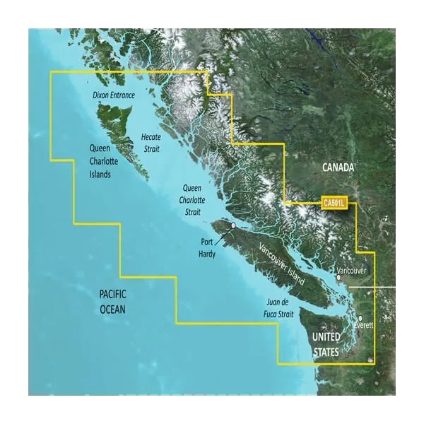
The Garmin BlueChart g3 Vision for Puget Sound to Dixon Entrance (model VCA501L) is a microSD/SD card charting solution that delivers integrated Garmin and Navionics data across one of North America's most complex coastal regions. This chart covers the waters from Puget Sound northward through the Queen Charlotte Islands and Hecate Strait to Dixon Entrance, spanning British Columbia waters and the Pacific Northwest. Boaters, commercial fishermen, and recreational navigators in this region rely on this specific coverage area for precise routing, obstacle avoidance, and fishing location identification in waters with variable depths and challenging tidal conditions.
Key Features
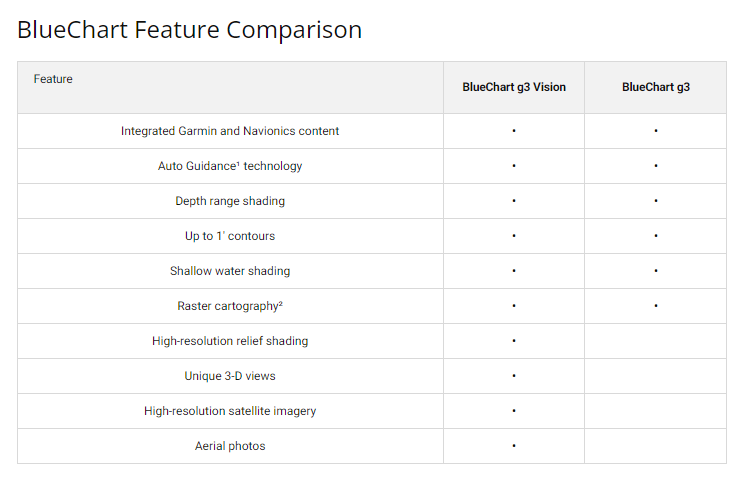
- Auto Guidance Technology generates suggested routes based on user-defined depth requirements and overhead clearance specifications
- High-Resolution Relief Shading displays underwater structure detail for identifying artificial and natural reefs
- Depth Range Shading visualizes up to 10 distinct depth categories for rapid water condition assessment
- Contour Accuracy up to 1-foot resolution enabling precise navigation through shallow passages and fishing grounds
- Shallow Water Shading with user-configurable depth alerts to highlight hazardous areas
- Integrated Navionics data combined with Garmin cartography for expanded coverage detail and accuracy verification
Data Insights
Users gain approximately 80% more detailed information compared to standard paper and basic digital charts. Route-planning efficiency improves significantly with Auto Guidance technology, reducing preparation time by up to 50% for complex passages. The 1-foot contour intervals provide the precision necessary for fishing in the region's tight depth windows where success depends on identifying bottom structure and depth transitions.
Usage Instructions
Insert the microSD/SD card into your compatible Garmin chartplotter or GPS device and follow on-screen activation prompts. Enable Auto Guidance features by setting your vessel's draft and overhead clearance limits, then select your destination to receive optimized routing suggestions. Update the chart data periodically through your Garmin device to maintain current information for this region's evolving navigation hazards and fish locations.
Design & Material
The VCA501L card delivers a compact, durable format engineered for marine environments where salt spray, moisture, and temperature fluctuations are constant challenges. The cartography displays at high resolution on compatible devices, eliminating the pixelation and readability issues common in older chart formats.
- Durable microSD/SD card construction rated for marine conditions and saltwater exposure
- High-resolution chart rendering ensures crisp detail on both small handheld and large multifunction displays
- Preloaded cartography ready for immediate use without extended configuration
- Compact card format stores easily in navigation kit and fits standard Garmin device slots
- Compatible with extensive Garmin chartplotter and GPS lineup including GPSMAP, echoMAP, and marine multifunction displays
- Seamless integration with sounder modules to overlay live depth and structure scanning over chart layers
Final Verdict
If you navigate the Puget Sound to Dixon Entrance region regularly, the BlueChart g3 Vision VCA501L eliminates the navigation guesswork that leads to grounding, missed fishing marks, and wasted fuel time. The combination of 1-foot contour precision, Auto Guidance routing, and integrated Garmin-Navionics data creates a competitive advantage for anyone who depends on this specific water system. Purchase the VCA501L to replace outdated paper charts and unreliable GPS basemaps with the charting standard trusted by commercial operators and serious recreational boaters in these waters.


