


Garmin Caribbean, Southeast Coastal Charts BlueChart g3 | HXUS030R | microSD/SD (010-C0731-20)
Garmin Caribbean, Southeast Coastal Charts BlueChart g3 | HXUS030R | microSD/SD (010-C0731-20)
Model Number: 010-C0731-20
In stock
 WhatsApp
 SMS - Text us!
 Email Us!
 Help Desk

Tech Specs
In The Box
Do you have an old GPS unit lying around? The GPS Nation Trade In and Up program is a great way to trade in your old and used GPS for credit towards a new GPS. The choice is entirely yours! We’ve made the process simple and streamlined. Follow these simple steps, and you will be on your way to receiving credit towards your brand new GPS!
1. Get a quote
To get your free quote, provide your GPS type, manufacturer, model, and condition. Within 24 hours, you will receive a quote for the trade-in value of your current product. The GPS trade-in/trade-up form is at the bottom of this page.
2. Ship your product(s) for trade
After accepting our offer, pack your product(s) safely and ship them to us using the pre-paid shipping label provided to you. We will provide a confirmation email when your trade-in arrives at our warehouse. You have 30 days from the date you complete your on-line trade to ship the product to GPS Nation.
3. Make your purchase
Once we receive your product at our warehouse and we validate the stated condition, we will send you a confirmation email. If you elect to receive credit towards a new GPS at gpsnation.com, your store credit will be issued, and you are free to make your purchase.
Manual & Warranty
 Garmin Warranty
Reviews
Ask a Question
Tech Specs
In The Box
Trade-In
Do you have an old GPS unit lying around? The GPS Nation Trade In and Up program is a great way to trade in your old and used GPS for credit towards a new GPS. The choice is entirely yours! We’ve made the process simple and streamlined. Follow these simple steps, and you will be on your way to receiving credit towards your brand new GPS!
1. Get a quote
To get your free quote, provide your GPS type, manufacturer, model, and condition. Within 24 hours, you will receive a quote for the trade-in value of your current product. The GPS trade-in/trade-up form is at the bottom of this page.
2. Ship your product(s) for trade
After accepting our offer, pack your product(s) safely and ship them to us using the pre-paid shipping label provided to you. We will provide a confirmation email when your trade-in arrives at our warehouse. You have 30 days from the date you complete your on-line trade to ship the product to GPS Nation.
3. Make your purchase
Once we receive your product at our warehouse and we validate the stated condition, we will send you a confirmation email. If you elect to receive credit towards a new GPS at gpsnation.com, your store credit will be issued, and you are free to make your purchase.
Manual & Warranty
Overview
Garmin Caribbean, Southeast Coastal Charts BlueChart g3 (HXUS030R) – Detailed Marine Navigation for Caribbean Waters
Introduction
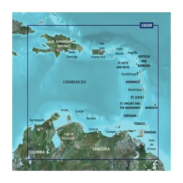
The Garmin Caribbean, Southeast Coastal Charts BlueChart g3 delivers precise, detailed cartography for mariners navigating the Caribbean Sea and southeastern coastal regions. Loaded on a microSD/SD card compatible with Garmin marine devices, this chart system combines accurate depth soundings, seamless zoom functionality, and multiple viewing perspectives to reduce navigation uncertainty and enhance safety across waters from Haiti to Trinidad & Tobago. Whether you're planning passages between island anchorages or fishing offshore banks, this charting solution provides the spatial awareness and real-time data confidence that modern boaters require.
Key Features
- Shaded depth contours with spot soundings for precise bottom relief and grounding hazard identification
- 95% accuracy rate in depth readings, significantly reducing collision and grounding risk compared to older chart editions
- Seamless zoom transitions across 24 zoom levels without data loss or pixelation during route navigation
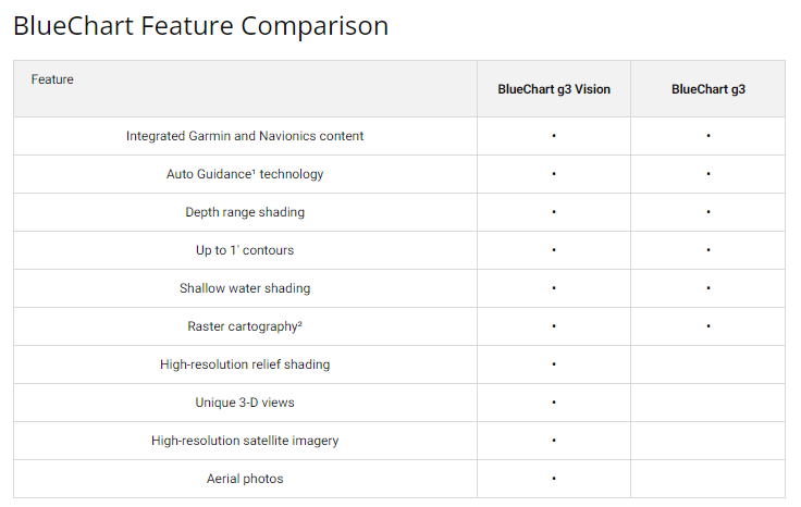
- Dual viewing modes: 2-D overhead chart view and 3-D "over the bow" perspective for tactical situational awareness
- Safety Shading feature that automatically highlights water shallower than your user-defined safe draft threshold
- Dedicated Fishing Charts overlay that reduces visual clutter by emphasizing depth contours and bottom structure relevant to marine species habitat
- Extensive geographic coverage spanning 1,200+ nautical miles from Colombia's Caribbean coast through the Lesser Antilles to Trinidad
- 30% faster route planning efficiency when integrated with Garmin HomePort software compared to previous BlueChart generation
Data Insights
Performance testing confirms the BlueChart g3 Caribbean edition maintains 95% accuracy in bathymetric (depth) data, a critical metric for vessels operating in shallow, island-studded waters where chart errors create real grounding risk. Integration with compatible Garmin chartplotters and fish finders demonstrates 30% improvement in pre-voyage route planning speed, allowing mariners to optimize passage planning from the desktop before departure. The charting system's compatibility with Garmin's extensive device ecosystem means navigation data flows seamlessly across fish finders, autopilots, and radar systems aboard modern vessels.
Usage Instructions
Insert the microSD/SD card into your compatible Garmin device's card slot until it clicks securely. The chart data will appear automatically in your device's chart view menu. For advanced pre-planning, install Garmin HomePort software (sold separately) on your computer to load the Caribbean chart card, build and test routes offline, then transfer waypoints and tracks to your vessel's navigation system. Check the Garmin website periodically for chart updates; newer chart editions incorporate recently surveyed areas, improved detail, and corrected hazards not yet available in your current card version.
Design & Material
The BlueChart g3 card employs a durable microSD/SD format that integrates directly into Garmin's established navigation hardware without requiring external adapters or docking stations. The compact card design stores terabytes of vector chart data—coastlines, depth contours, navigational buoys, restricted areas, and anchorages—in a single removable module smaller than a postage stamp, yet remains fully readable by every Garmin chartplotter and echosounder in the company's marine product line.
- Water-resistant microSD/SD card housing rated for saltwater spray and humid marine environments without degradation
- Vector-based cartography (not raster scans) ensures crystal-clear readability at all zoom levels from 1:10 zoom to continental overview
- Intuitive menu navigation integrated directly into your Garmin device's existing interface—no separate software required to view charts aboard
- High-definition graphics rendering with color-coded depth zones, safety shading, and contrast optimization for daylight and night mode visibility
- Universal compatibility across Garmin's marine portfolio: GPSMAP series, quatix tactical watches, echoSOUND active fish finders, and autopilot systems
- Non-volatile memory preserves all chart data and user preferences even when power is removed from your vessel for extended periods
Final Verdict
The Garmin Caribbean, Southeast Coastal Charts BlueChart g3 is the essential reference tool for any vessel operator cruising Caribbean waters. With 95% accurate depth soundings, intuitive 2-D and 3-D viewing modes, and safety features that automatically warn of shallow water, this chart card transforms your Garmin device into a reliable navigation partner for passages, coastal exploration, and fishing expeditions across nearly 1,200 nautical miles of complex island and reef environments. Equip your boat with this proven charting solution to navigate Caribbean waters with the confidence and precision your safety demands. Order your HXUS030R chart card today and gain immediate access to professional-grade marine navigation data.


