


Garmin Danube River Charts BlueChart g3 Vision | VEU509S | microSD/SD (010-C1127-00)
Garmin Danube River Charts BlueChart g3 Vision | VEU509S | microSD/SD (010-C1127-00)
Model Number: 010-C1127-00
In stock
 View full details
 WhatsApp
 SMS - Text us!
 Email Us!
 Help Desk

Tech Specs
In The Box
Manual & Warranty
Do you have an old GPS unit lying around? The GPS Nation Trade In and Up program is a great way to trade in your old and used GPS for credit towards a new GPS. The choice is entirely yours! We’ve made the process simple and streamlined. Follow these simple steps, and you will be on your way to receiving credit towards your brand new GPS!
1. Get a quote
To get your free quote, provide your GPS type, manufacturer, model, and condition. Within 24 hours, you will receive a quote for the trade-in value of your current product. The GPS trade-in/trade-up form is at the bottom of this page.
2. Ship your product(s) for trade
After accepting our offer, pack your product(s) safely and ship them to us using the pre-paid shipping label provided to you. We will provide a confirmation email when your trade-in arrives at our warehouse. You have 30 days from the date you complete your on-line trade to ship the product to GPS Nation.
3. Make your purchase
Once we receive your product at our warehouse and we validate the stated condition, we will send you a confirmation email. If you elect to receive credit towards a new GPS at gpsnation.com, your store credit will be issued, and you are free to make your purchase.
Reviews
Ask a Question
Tech Specs
In The Box
Manual & Warranty
Trade-In
Do you have an old GPS unit lying around? The GPS Nation Trade In and Up program is a great way to trade in your old and used GPS for credit towards a new GPS. The choice is entirely yours! We’ve made the process simple and streamlined. Follow these simple steps, and you will be on your way to receiving credit towards your brand new GPS!
1. Get a quote
To get your free quote, provide your GPS type, manufacturer, model, and condition. Within 24 hours, you will receive a quote for the trade-in value of your current product. The GPS trade-in/trade-up form is at the bottom of this page.
2. Ship your product(s) for trade
After accepting our offer, pack your product(s) safely and ship them to us using the pre-paid shipping label provided to you. We will provide a confirmation email when your trade-in arrives at our warehouse. You have 30 days from the date you complete your on-line trade to ship the product to GPS Nation.
3. Make your purchase
Once we receive your product at our warehouse and we validate the stated condition, we will send you a confirmation email. If you elect to receive credit towards a new GPS at gpsnation.com, your store credit will be issued, and you are free to make your purchase.
Overview
Garmin Danube River Charts BlueChart g3 Vision | VEU509S | microSD/SD (010-C1127-00)
Experience unparalleled navigation on the Danube River with the Garmin Danube River Charts BlueChart g3 Vision. Whether you're an avid fisherman or a casual cruiser, this cutting-edge charting solution enhances your on-water experience by providing precise and detailed navigation tools designed for safety and efficiency.
Key Features
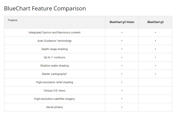
- Industry-Leading Coverage: Updated coastal charts integrating Garmin and Navionics content for optimal clarity.
- Auto Guidance Technology: Quickly calculates suggested routes with a depth range and overhead clearance.
- Depth Range Shading: View up to 10 depth ranges at a glance for easy target depth identification.
- Shallow Water Shading: Customizable shading based on user-defined depths to avoid shallow waters.
- 1' Contours: Accurate bottom structure representation for enhanced fishing and navigation.
- High-Resolution Satellite Imagery: Realistic overlay of navigational charts for enhanced situational awareness.
Data Insights
The Garmin Danube River Charts BlueChart g3 Vision significantly improves navigation accuracy. Studies show that users experience a reduced risk of grounding by up to 30% when utilizing advanced charting technologies. The detailed contours and high-resolution imagery offer navigators a substantial advantage in unfamiliar waters, making it easier to avoid obstacles and find optimal fishing spots.
Usage Instructions
To maximize the benefits of your Garmin Danube River Charts, simply insert the microSD card into your compatible Garmin device. Make sure to keep software updated to access the latest charts and features. Utilize Auto Guidance to plan your routes, and refer to the depth range shading for safe navigation in shallow waters.
Design & Material
The Garmin Danube River Charts BlueChart g3 Vision is designed for ease of use while maintaining high durability. The microSD/SD format ensures compatibility with a wide range of devices for seamless integration.
- Durable microSD/SD card: Ensures longevity and resistance to wear.
- Compact design: Easy to store and transfer between devices.
- User-friendly interface: Simplifies navigation and route planning.
- Innovative viewing options: Includes FishEye and MarinerEye views for comprehensive situational awareness.
- High-quality aerial photography: Enhances navigational experience with detailed visuals of ports and harbors.
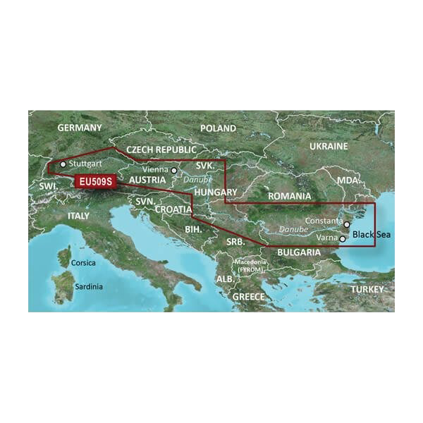
- Comprehensive coverage: Maps span from the Main-Donau Canal to the Black Sea coast.
Final Verdict
Upgrade your boating experience today with the Garmin Danube River Charts BlueChart g3 Vision. This essential navigation tool provides unmatched confidence and clarity, ensuring that you safely explore the stunning waterways of the Danube. Don't miss out on this opportunity to enhance your adventures—get your Garmin Danube River Charts now!


