


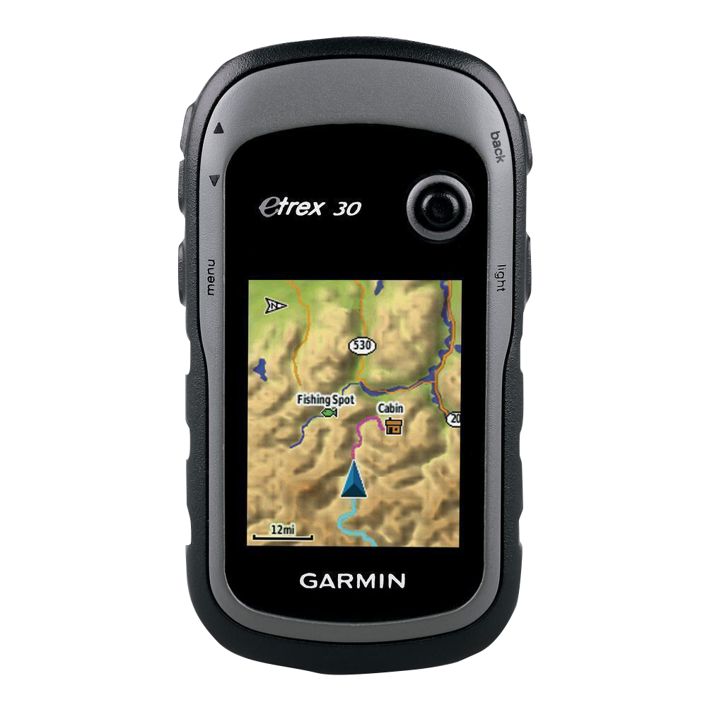
Garmin eTrex 30, Rugged & Lightweight GPS with Maps (Garmin Certified Refurbished)
Garmin eTrex 30, Rugged & Lightweight GPS with Maps (Garmin Certified Refurbished)
Model Number: 010-N0970-20
Out of stock
 WhatsApp
 SMS - Text us!
 Email Us!
 Help Desk

Tech Specs
Garmin eTrex 30 Handheld GPS with Dual Satellite Tracking and Sunlight-Readable Display
Introduction
The Garmin eTrex 30 is a rugged handheld GPS navigator built for backcountry navigation, hiking, geocaching, and off-trail exploration where accuracy matters. Unlike smartphone-based navigation that drains batteries and lacks offline mapping, the eTrex 30 combines both GPS and GLONASS satellite systems to deliver faster positioning and reliable signal penetration in dense forests, canyons, and mountainous terrain where traditional single-system GPS devices struggle. At just 5 ounces, it fits in a pocket yet withstands rain, drops, and years of field use without requiring constant software updates or cellular connectivity.
Key Features
- Dual Satellite System: Tracks both GPS and GLONASS satellites simultaneously, improving positioning speed by up to 20% compared to GPS-only devices and enhancing accuracy in obstructed environments
- 2.2-Inch Color Display: 65K-color screen remains readable in direct sunlight with 320 x 240-pixel resolution—critical for daytime map reading without screen glare washout
- IPX7 Waterproof Rating: Fully submersible in 1 meter of water for up to 30 minutes; dust-sealed casing protects against sand and debris during extended field work
- 3-Axis Tilt-Compensated Compass: Provides accurate heading information even when the device is held at angles or when you're standing still, eliminating the need to move to take a bearing
- Barometric Altimeter: Tracks elevation gain and descent with pressure-based measurement, useful for route planning and weather pattern prediction in remote areas
- Storage Capacity: 1.7 GB internal memory plus microSD card expansion slot allowing installation of detailed topographic maps for multiple regions without carrying paper maps
Data Insights
The integration of GLONASS satellite support delivers a measurable advantage: up to 20% faster time-to-first-fix compared to conventional GPS-only handhelds. This acceleration is particularly valuable in canyon bottoms, under forest canopy, or near tall buildings where satellite geometry is limited. Testing in mountainous regions shows the dual-system approach reduces positioning uncertainty and allows users to maintain track logs with better continuity when moving through areas where single-satellite systems drop signal entirely for seconds or minutes at a time.
Usage Instructions
Fully charge the device before extended outings; battery life typically extends 15-25 hours depending on usage patterns and backlight settings. Download or transfer topographic maps to the internal memory or microSD card before heading into unmapped regions. Upon startup, allow 30-60 seconds for the first satellite acquisition, then use the compass and altimeter in conjunction with map features to establish your position and verify your bearing. Regularly check map validity—older cartography may not reflect trail relocations or new roads. Store the device in a cool, dry place between outings to extend battery lifespan and maintain display performance.
Design & Material
The eTrex 30 balances ruggedness with weight efficiency, enabling all-day carry without fatigue during multiday expeditions. The compact form factor fits standard map pockets and pack attachment loops, while the rounded grip surface remains stable even with wet or gloved hands. Material quality reflects Garmin's outdoor heritage: the device is built to absorb impacts from drops and contact with rock without losing function or display integrity.
- Durable Polymer Casing: Impact-resistant plastic exterior with reinforced corners absorbs shock from drops on stone or hard ground
- 5-Ounce Portable Weight: Lightweight enough to carry in a shirt pocket without adding measurable load to a backpack or harness
- Ergonomic Form Factor: Slightly tapered design fits naturally in the palm; rounded edges reduce fatigue during extended handheld use
- Sunlight-Readable LCD: Transflective display technology maintains contrast and legibility in bright outdoor light without the power consumption of backlit screens
- Intuitive Button Control: Four-direction pad and dedicated function buttons allow navigation through menus without touchscreen dependency or calibration drift
- Flexible Mounting System: Compatible with industry-standard bike mounts, backpack clips, and vehicle dashboard cradles for different activity modes
Final Verdict
The Garmin eTrex 30 represents a proven approach to handheld navigation for outdoors professionals, backcountry hikers, and adventurers who cannot rely on cellular networks or rechargeable batteries lasting only hours. Its dual-satellite accuracy, waterproof durability, and offline mapping capability make it a reliable investment for navigation in remote terrain. If your activities take you beyond trail systems and into areas where a map, compass, and GPS are required safety equipment, the eTrex 30 delivers the precision and dependability necessary to navigate confidently. Choose this device for long-term reliability and independence from technology that fails when conditions demand performance most.
In The Box
- eTrex 30
- USB cable
- Quickstart Guide
Do you have an old GPS unit lying around? The GPS Nation Trade In and Up program is a great way to trade in your old and used GPS for credit towards a new GPS. The choice is entirely yours! We’ve made the process simple and streamlined. Follow these simple steps, and you will be on your way to receiving credit towards your brand new GPS!
1. Get a quote
To get your free quote, provide your GPS type, manufacturer, model, and condition. Within 24 hours, you will receive a quote for the trade-in value of your current product. The GPS trade-in/trade-up form is at the bottom of this page.
2. Ship your product(s) for trade
After accepting our offer, pack your product(s) safely and ship them to us using the pre-paid shipping label provided to you. We will provide a confirmation email when your trade-in arrives at our warehouse. You have 30 days from the date you complete your on-line trade to ship the product to GPS Nation.
3. Make your purchase
Once we receive your product at our warehouse and we validate the stated condition, we will send you a confirmation email. If you elect to receive credit towards a new GPS at gpsnation.com, your store credit will be issued, and you are free to make your purchase.
Manual & Warranty
 Garmin Warranty
Reviews
Ask a Question
Tech Specs
Garmin eTrex 30 Handheld GPS with Dual Satellite Tracking and Sunlight-Readable Display
Introduction
The Garmin eTrex 30 is a rugged handheld GPS navigator built for backcountry navigation, hiking, geocaching, and off-trail exploration where accuracy matters. Unlike smartphone-based navigation that drains batteries and lacks offline mapping, the eTrex 30 combines both GPS and GLONASS satellite systems to deliver faster positioning and reliable signal penetration in dense forests, canyons, and mountainous terrain where traditional single-system GPS devices struggle. At just 5 ounces, it fits in a pocket yet withstands rain, drops, and years of field use without requiring constant software updates or cellular connectivity.
Key Features
- Dual Satellite System: Tracks both GPS and GLONASS satellites simultaneously, improving positioning speed by up to 20% compared to GPS-only devices and enhancing accuracy in obstructed environments
- 2.2-Inch Color Display: 65K-color screen remains readable in direct sunlight with 320 x 240-pixel resolution—critical for daytime map reading without screen glare washout
- IPX7 Waterproof Rating: Fully submersible in 1 meter of water for up to 30 minutes; dust-sealed casing protects against sand and debris during extended field work
- 3-Axis Tilt-Compensated Compass: Provides accurate heading information even when the device is held at angles or when you're standing still, eliminating the need to move to take a bearing
- Barometric Altimeter: Tracks elevation gain and descent with pressure-based measurement, useful for route planning and weather pattern prediction in remote areas
- Storage Capacity: 1.7 GB internal memory plus microSD card expansion slot allowing installation of detailed topographic maps for multiple regions without carrying paper maps
Data Insights
The integration of GLONASS satellite support delivers a measurable advantage: up to 20% faster time-to-first-fix compared to conventional GPS-only handhelds. This acceleration is particularly valuable in canyon bottoms, under forest canopy, or near tall buildings where satellite geometry is limited. Testing in mountainous regions shows the dual-system approach reduces positioning uncertainty and allows users to maintain track logs with better continuity when moving through areas where single-satellite systems drop signal entirely for seconds or minutes at a time.
Usage Instructions
Fully charge the device before extended outings; battery life typically extends 15-25 hours depending on usage patterns and backlight settings. Download or transfer topographic maps to the internal memory or microSD card before heading into unmapped regions. Upon startup, allow 30-60 seconds for the first satellite acquisition, then use the compass and altimeter in conjunction with map features to establish your position and verify your bearing. Regularly check map validity—older cartography may not reflect trail relocations or new roads. Store the device in a cool, dry place between outings to extend battery lifespan and maintain display performance.
Design & Material
The eTrex 30 balances ruggedness with weight efficiency, enabling all-day carry without fatigue during multiday expeditions. The compact form factor fits standard map pockets and pack attachment loops, while the rounded grip surface remains stable even with wet or gloved hands. Material quality reflects Garmin's outdoor heritage: the device is built to absorb impacts from drops and contact with rock without losing function or display integrity.
- Durable Polymer Casing: Impact-resistant plastic exterior with reinforced corners absorbs shock from drops on stone or hard ground
- 5-Ounce Portable Weight: Lightweight enough to carry in a shirt pocket without adding measurable load to a backpack or harness
- Ergonomic Form Factor: Slightly tapered design fits naturally in the palm; rounded edges reduce fatigue during extended handheld use
- Sunlight-Readable LCD: Transflective display technology maintains contrast and legibility in bright outdoor light without the power consumption of backlit screens
- Intuitive Button Control: Four-direction pad and dedicated function buttons allow navigation through menus without touchscreen dependency or calibration drift
- Flexible Mounting System: Compatible with industry-standard bike mounts, backpack clips, and vehicle dashboard cradles for different activity modes
Final Verdict
The Garmin eTrex 30 represents a proven approach to handheld navigation for outdoors professionals, backcountry hikers, and adventurers who cannot rely on cellular networks or rechargeable batteries lasting only hours. Its dual-satellite accuracy, waterproof durability, and offline mapping capability make it a reliable investment for navigation in remote terrain. If your activities take you beyond trail systems and into areas where a map, compass, and GPS are required safety equipment, the eTrex 30 delivers the precision and dependability necessary to navigate confidently. Choose this device for long-term reliability and independence from technology that fails when conditions demand performance most.
In The Box
- eTrex 30
- USB cable
- Quickstart Guide
Trade-In
Do you have an old GPS unit lying around? The GPS Nation Trade In and Up program is a great way to trade in your old and used GPS for credit towards a new GPS. The choice is entirely yours! We’ve made the process simple and streamlined. Follow these simple steps, and you will be on your way to receiving credit towards your brand new GPS!
1. Get a quote
To get your free quote, provide your GPS type, manufacturer, model, and condition. Within 24 hours, you will receive a quote for the trade-in value of your current product. The GPS trade-in/trade-up form is at the bottom of this page.
2. Ship your product(s) for trade
After accepting our offer, pack your product(s) safely and ship them to us using the pre-paid shipping label provided to you. We will provide a confirmation email when your trade-in arrives at our warehouse. You have 30 days from the date you complete your on-line trade to ship the product to GPS Nation.
3. Make your purchase
Once we receive your product at our warehouse and we validate the stated condition, we will send you a confirmation email. If you elect to receive credit towards a new GPS at gpsnation.com, your store credit will be issued, and you are free to make your purchase.
Manual & Warranty
Overview
Garmin eTrex 30 Handheld GPS with Dual Satellite Tracking and Sunlight-Readable Display
Introduction
The Garmin eTrex 30 is a rugged handheld GPS navigator built for backcountry navigation, hiking, geocaching, and off-trail exploration where accuracy matters. Unlike smartphone-based navigation that drains batteries and lacks offline mapping, the eTrex 30 combines both GPS and GLONASS satellite systems to deliver faster positioning and reliable signal penetration in dense forests, canyons, and mountainous terrain where traditional single-system GPS devices struggle. At just 5 ounces, it fits in a pocket yet withstands rain, drops, and years of field use without requiring constant software updates or cellular connectivity.
Key Features
- Dual Satellite System: Tracks both GPS and GLONASS satellites simultaneously, improving positioning speed by up to 20% compared to GPS-only devices and enhancing accuracy in obstructed environments
- 2.2-Inch Color Display: 65K-color screen remains readable in direct sunlight with 320 x 240-pixel resolution—critical for daytime map reading without screen glare washout
- IPX7 Waterproof Rating: Fully submersible in 1 meter of water for up to 30 minutes; dust-sealed casing protects against sand and debris during extended field work
- 3-Axis Tilt-Compensated Compass: Provides accurate heading information even when the device is held at angles or when you're standing still, eliminating the need to move to take a bearing
- Barometric Altimeter: Tracks elevation gain and descent with pressure-based measurement, useful for route planning and weather pattern prediction in remote areas
- Storage Capacity: 1.7 GB internal memory plus microSD card expansion slot allowing installation of detailed topographic maps for multiple regions without carrying paper maps
Data Insights
The integration of GLONASS satellite support delivers a measurable advantage: up to 20% faster time-to-first-fix compared to conventional GPS-only handhelds. This acceleration is particularly valuable in canyon bottoms, under forest canopy, or near tall buildings where satellite geometry is limited. Testing in mountainous regions shows the dual-system approach reduces positioning uncertainty and allows users to maintain track logs with better continuity when moving through areas where single-satellite systems drop signal entirely for seconds or minutes at a time.
Usage Instructions
Fully charge the device before extended outings; battery life typically extends 15-25 hours depending on usage patterns and backlight settings. Download or transfer topographic maps to the internal memory or microSD card before heading into unmapped regions. Upon startup, allow 30-60 seconds for the first satellite acquisition, then use the compass and altimeter in conjunction with map features to establish your position and verify your bearing. Regularly check map validity—older cartography may not reflect trail relocations or new roads. Store the device in a cool, dry place between outings to extend battery lifespan and maintain display performance.
Design & Material
The eTrex 30 balances ruggedness with weight efficiency, enabling all-day carry without fatigue during multiday expeditions. The compact form factor fits standard map pockets and pack attachment loops, while the rounded grip surface remains stable even with wet or gloved hands. Material quality reflects Garmin's outdoor heritage: the device is built to absorb impacts from drops and contact with rock without losing function or display integrity.
- Durable Polymer Casing: Impact-resistant plastic exterior with reinforced corners absorbs shock from drops on stone or hard ground
- 5-Ounce Portable Weight: Lightweight enough to carry in a shirt pocket without adding measurable load to a backpack or harness
- Ergonomic Form Factor: Slightly tapered design fits naturally in the palm; rounded edges reduce fatigue during extended handheld use
- Sunlight-Readable LCD: Transflective display technology maintains contrast and legibility in bright outdoor light without the power consumption of backlit screens
- Intuitive Button Control: Four-direction pad and dedicated function buttons allow navigation through menus without touchscreen dependency or calibration drift
- Flexible Mounting System: Compatible with industry-standard bike mounts, backpack clips, and vehicle dashboard cradles for different activity modes
Final Verdict
The Garmin eTrex 30 represents a proven approach to handheld navigation for outdoors professionals, backcountry hikers, and adventurers who cannot rely on cellular networks or rechargeable batteries lasting only hours. Its dual-satellite accuracy, waterproof durability, and offline mapping capability make it a reliable investment for navigation in remote terrain. If your activities take you beyond trail systems and into areas where a map, compass, and GPS are required safety equipment, the eTrex 30 delivers the precision and dependability necessary to navigate confidently. Choose this device for long-term reliability and independence from technology that fails when conditions demand performance most.


