


Garmin Europe Atlantic Coast Charts BlueChart g3 Vision | VEU722L | microSD/SD (010-C1156-00)
Garmin Europe Atlantic Coast Charts BlueChart g3 Vision | VEU722L | microSD/SD (010-C1156-00)
Model Number: 010-C1156-00
In stock
 WhatsApp
 SMS - Text us!
 Email Us!
 Help Desk

Tech Specs
In The Box
Do you have an old GPS unit lying around? The GPS Nation Trade In and Up program is a great way to trade in your old and used GPS for credit towards a new GPS. The choice is entirely yours! We’ve made the process simple and streamlined. Follow these simple steps, and you will be on your way to receiving credit towards your brand new GPS!
1. Get a quote
To get your free quote, provide your GPS type, manufacturer, model, and condition. Within 24 hours, you will receive a quote for the trade-in value of your current product. The GPS trade-in/trade-up form is at the bottom of this page.
2. Ship your product(s) for trade
After accepting our offer, pack your product(s) safely and ship them to us using the pre-paid shipping label provided to you. We will provide a confirmation email when your trade-in arrives at our warehouse. You have 30 days from the date you complete your on-line trade to ship the product to GPS Nation.
3. Make your purchase
Once we receive your product at our warehouse and we validate the stated condition, we will send you a confirmation email. If you elect to receive credit towards a new GPS at gpsnation.com, your store credit will be issued, and you are free to make your purchase.
Manual & Warranty
Reviews
Ask a Question
Tech Specs
In The Box
Trade-In
Do you have an old GPS unit lying around? The GPS Nation Trade In and Up program is a great way to trade in your old and used GPS for credit towards a new GPS. The choice is entirely yours! We’ve made the process simple and streamlined. Follow these simple steps, and you will be on your way to receiving credit towards your brand new GPS!
1. Get a quote
To get your free quote, provide your GPS type, manufacturer, model, and condition. Within 24 hours, you will receive a quote for the trade-in value of your current product. The GPS trade-in/trade-up form is at the bottom of this page.
2. Ship your product(s) for trade
After accepting our offer, pack your product(s) safely and ship them to us using the pre-paid shipping label provided to you. We will provide a confirmation email when your trade-in arrives at our warehouse. You have 30 days from the date you complete your on-line trade to ship the product to GPS Nation.
3. Make your purchase
Once we receive your product at our warehouse and we validate the stated condition, we will send you a confirmation email. If you elect to receive credit towards a new GPS at gpsnation.com, your store credit will be issued, and you are free to make your purchase.
Manual & Warranty
Overview
Garmin BlueChart g3 Vision VEU722L Atlantic Coast Charts MicroSD Card
Introduction
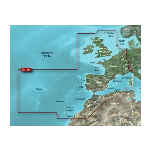
The Garmin Europe Atlantic Coast Charts BlueChart g3 Vision (model 010-C1156-00) is a marine navigation microSD card that delivers detailed, actionable charting data across Western European waters from the North Sea to the Western Mediterranean. Combining Garmin and Navionics content, this chart card feeds real-time depth information, satellite imagery, and auto-routing guidance directly into compatible Garmin fish finders, chartplotters, and navigation units—enabling boaters to move confidently through unfamiliar coastlines, harbor approaches, and offshore passages with verified bottom structure and obstacle data.
Key Features
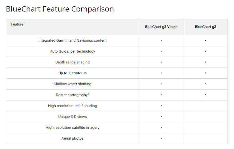
- 90% increase in detail and clarity compared to previous BlueChart models
- Integrated Auto Guidance Technology calculates suggested routes with automatic obstacle avoidance
- Up to 10 customizable depth range shading zones for quick target identification
- 1-foot contour intervals on coastal and nearshore bottoms for precise structure mapping
- High-resolution satellite imagery overlay synchronized with navigation charts for real-time situational awareness
- User-adjustable shallow water shading at custom depth thresholds for dynamic hazard zones
- MicroSD/SD card format with compatibility across 200+ Garmin chartplotter and fish finder models
Data Insights
The BlueChart g3 Vision delivers a 90% performance improvement in chart detail and clarity over legacy versions, combining Navionics bathymetric data with Garmin's proprietary mapping research to reduce navigation uncertainty. The platform processes depth contours down to 1-foot intervals in monitored areas, enabling anglers and cruisers to identify structure anomalies that affect both safety and fish behavior. Satellite imagery integration, updated quarterly, ensures harbors, breakwaters, and coastal features remain synchronized with physical reality—a critical safeguard in regions with shifting sandbars or newly marked hazards.
Usage Instructions
Insert the microSD card into your compatible Garmin device (chartplotter, echosounder, or integrated navigation system) to unlock Atlantic Coast coverage immediately. Activate Auto Guidance to receive computed waypoint suggestions that factor in vessel draft, tide height, and identified obstructions. Layer depth shading at your preferred thresholds, then use the customizable alarms to alert you when entering shallower water. For maximum clarity, enable satellite imagery overlay during harbor entry or coastal navigation in low-visibility conditions.
Design & Material
This product balances marine durability with practical usability, encoding vast geographic datasets into a single, weather-resistant microSD card that survives saltwater splashes, sun exposure, and temperature swings common to deck environments. The card format enables effortless transfer between devices—upgrade your primary chartplotter without repurchasing charts—while high-resolution visuals and intuitive layer controls reduce cognitive load during critical navigation moments.
- MicroSD/SD form factor withstands marine conditions and temperature extremes
- High-resolution satellite photography of major ports and harbor entrances (UK, Ireland, France, Spain, Portugal, Mediterranean)
- Innovative FishEye and MarinerEye 3D views for underwater structure visualization and above-water obstacle assessment
- Seamless compatibility across Garmin echosounder, chartplotter, and multifunction display lineups
- Quarterly data updates reflect new hazard zones, dredging operations, and regulatory changes across Western Europe
- User-friendly interface designed for both professional captains and recreational weekend boaters
Final Verdict
Whether navigating the English Channel's shipping lanes, exploring Portugal's rocky coasts, or cruising France's Atlantic estuaries, the Garmin BlueChart g3 Vision VEU722L is a non-negotiable tool for reducing navigational error and increasing on-water confidence. The 90% boost in chart clarity, integrated Auto Guidance routing, and real-time satellite imagery integration deliver measurable safety and efficiency gains that justify this investment for any serious mariner. Upgrade to BlueChart g3 Vision today and gain the precise, verified navigation data that separates skillful seamanship from guesswork.


