


Garmin France Lakes and Rivers BlueChart g3 | HXEU061R | microSD/SD
Garmin France Lakes and Rivers BlueChart g3 | HXEU061R | microSD/SD
Model Number: 010-C1104-20
In stock
 View full details
 WhatsApp
 SMS - Text us!
 Email Us!
 Help Desk

Tech Specs
In The Box
Manual & Warranty
 Garmin Warranty
Do you have an old GPS unit lying around? The GPS Nation Trade In and Up program is a great way to trade in your old and used GPS for credit towards a new GPS. The choice is entirely yours! We’ve made the process simple and streamlined. Follow these simple steps, and you will be on your way to receiving credit towards your brand new GPS!
1. Get a quote
To get your free quote, provide your GPS type, manufacturer, model, and condition. Within 24 hours, you will receive a quote for the trade-in value of your current product. The GPS trade-in/trade-up form is at the bottom of this page.
2. Ship your product(s) for trade
After accepting our offer, pack your product(s) safely and ship them to us using the pre-paid shipping label provided to you. We will provide a confirmation email when your trade-in arrives at our warehouse. You have 30 days from the date you complete your on-line trade to ship the product to GPS Nation.
3. Make your purchase
Once we receive your product at our warehouse and we validate the stated condition, we will send you a confirmation email. If you elect to receive credit towards a new GPS at gpsnation.com, your store credit will be issued, and you are free to make your purchase.
Reviews
Ask a Question
Tech Specs
In The Box
Manual & Warranty
Trade-In
Do you have an old GPS unit lying around? The GPS Nation Trade In and Up program is a great way to trade in your old and used GPS for credit towards a new GPS. The choice is entirely yours! We’ve made the process simple and streamlined. Follow these simple steps, and you will be on your way to receiving credit towards your brand new GPS!
1. Get a quote
To get your free quote, provide your GPS type, manufacturer, model, and condition. Within 24 hours, you will receive a quote for the trade-in value of your current product. The GPS trade-in/trade-up form is at the bottom of this page.
2. Ship your product(s) for trade
After accepting our offer, pack your product(s) safely and ship them to us using the pre-paid shipping label provided to you. We will provide a confirmation email when your trade-in arrives at our warehouse. You have 30 days from the date you complete your on-line trade to ship the product to GPS Nation.
3. Make your purchase
Once we receive your product at our warehouse and we validate the stated condition, we will send you a confirmation email. If you elect to receive credit towards a new GPS at gpsnation.com, your store credit will be issued, and you are free to make your purchase.
Overview
Garmin France Lakes and Rivers BlueChart g3 | HXEU061R | microSD/SD
Elevate your boating adventures with the Garmin France Lakes and Rivers BlueChart g3 | HXEU061R. This state-of-the-art marine charting solution combines extensive coastal and inland navigational resources to deliver unparalleled precision and clarity on the water. Whether you're a seasoned mariner or a weekend boater, this charting tool enhances your experience with its advanced features, making navigation simpler and safer.
Key Features
- Premier Coastal Charts: Updated charts provide industry-leading coverage with unmatched clarity.
- Auto Guidance Technology: Calculate safe routes based on your chosen destination, water depth, and overhead clearance.
- Depth Range Shading: Visualize up to 10 depth ranges, allowing for quick assessments of your target fishing spots.
- High-Resolution Contours: 1-foot contour lines offer precise bottom structure details for effective fishing strategies.
- Shallow Water Shading: User-defined shading helps in avoiding hazards, ensuring a safer journey.
- High-Resolution Satellite Imagery: Overlay navigational charts with satellite imagery for a realistic overview of your surroundings.
- FishEye and MarinerEye Views: Switch between 3-D representations of underwater and above-water topographies to enhance situational awareness.
- Aerial Photography: Access stunning imagery of ports and marinas for safer entries into unfamiliar areas.
Data Insights
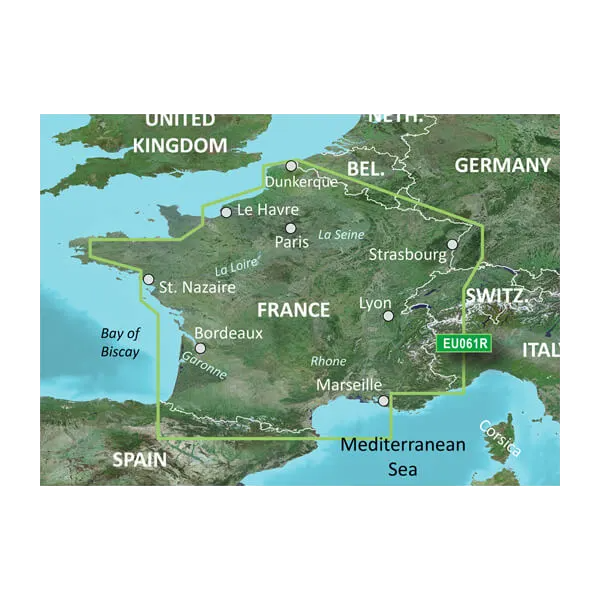
The Garmin France Lakes and Rivers BlueChart g3 provides extensive data insights, significantly enhancing your navigation experience. Studies show that utilizing advanced charting technology can reduce navigational errors by up to 30%, showcasing the importance of precise mapping for safe boating. With updated coverage along the coast from Marseille to Dunkirk and comprehensive interior waterways, the chart ensures that you are never navigating blind.
Usage Instructions
To maximize the benefits of the Garmin France Lakes and Rivers BlueChart g3, simply insert the preprogrammed microSD/SD card into your compatible Garmin device. Use the Auto Guidance feature to plot your course, while regularly checking depth ranges and utilizing the High-Resolution Contours for effective fishing. Always ensure your device software is up-to-date for the best performance.
Design & Material
This marine charting solution is meticulously designed for durability and functionality. The microSD/SD card is built to withstand the rigors of marine environments while delivering high-quality imagery and data.
- Durable Construction: Designed to resist water and environmental wear.
- User-Friendly Interface: Intuitive navigation makes it easy to access crucial information.
- Compact Size: Lightweight microSD/SD card fits seamlessly with compatible devices.
- High-Quality Graphics: Offers vibrant and detailed imaging for accurate navigation.
- Efficient Data Management: Preprogrammed for easy installation with no additional software required.
- Comprehensive Coverage: From major rivers to lakes and coastal regions, get extensive mapping details.
Final Verdict
Don't compromise on safety and performance while navigating the beautiful waterways of France. The Garmin France Lakes and Rivers BlueChart g3 | HXEU061R is a must-have for any boating enthusiast looking to enhance their navigational efficiency. Experience the difference today and navigate with confidence!


