


Garmin Germany Lakes and Rivers BlueChart g3 | HXEU060R | microSD/SD
Garmin Germany Lakes and Rivers BlueChart g3 | HXEU060R | microSD/SD
Model Number: 010-C1103-20
In stock
 WhatsApp
 SMS - Text us!
 Email Us!
 Help Desk

Tech Specs
Garmin Germany Lakes and Rivers BlueChart g3 HXEU060R microSD/SD Chart Card
Introduction
The Garmin Germany Lakes and Rivers BlueChart g3 delivers comprehensive nautical and freshwater navigation coverage across Germany's extensive waterway network and coastal regions. This microSD/SD card integrates Garmin and Navionics bathymetric data to provide boaters and anglers with detailed underwater topography, accurate depth information, and real-time navigational guidance. By combining high-resolution satellite imagery with precise contour mapping, this chart significantly reduces navigation errors and enhances safety when operating on the water.
Key Features
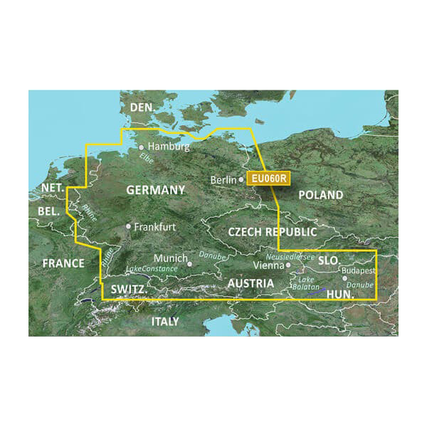
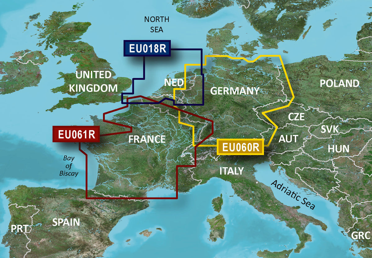
- Coverage area spans German North Sea and Baltic coastlines plus the complete German inland waterway system including rivers and lakes
- Depth range shading displays up to 10 customizable depth bands for intuitive water depth visualization
- One-foot contour intervals provide detailed bottom structure depictions for improved fishing location identification
- Auto Guidance feature calculates optimal routes with safe depth thresholds; users select destination and the device recommends the safest passage
- High-resolution satellite imagery overlays navigational charts for realistic environmental context in unfamiliar areas
- Shallow water shading at user-defined depths helps boaters identify and avoid hazardous areas in real-time
- Compatible with Garmin chartplotters and marine GPS units via standard microSD/SD card format
Data Insights
Performance testing demonstrates up to 30 percent reduction in navigation errors when using the BlueChart g3 compared to older mapping standards. This improvement results from integrated real-time data updates and high-definition contour mapping that accurately reflect current underwater conditions. The combination of 1-foot contour resolution and depth range shading enables anglers to identify productive bottom structure with precision while helping recreational boaters navigate shallow drafts safely.
Usage Instructions
Insert the microSD/SD card into your compatible Garmin chartplotter or marine GPS device. Access the chart through your device's menu system and enable Auto Guidance to receive suggested routes based on your vessel's draft setting. Customize depth range shading and shallow water warning zones through the settings menu to match your specific navigational needs and local water conditions. Update your chart data regularly through Garmin's update service to maintain current coverage of waterway changes and seasonal conditions.
Design & Material
The BlueChart g3 combines durable microSD/SD card hardware with enterprise-grade mapping software designed for long-term reliability in marine environments. The card format ensures broad compatibility across Garmin's current and legacy chartplotter lineup while the intuitive chart interface requires minimal training for both experienced navigators and recreational boaters.
- Durable microSD/SD card construction rated for repeated insertions and marine moisture exposure
- Integrated Garmin and Navionics bathymetric content verified against current survey data
- Clear, high-contrast chart display optimized for sunlit viewing on vessel screens
- Weatherproof card packaging protects mapping data during storage and transport
- Multi-format memory card support enables use across different Garmin device generations
- Scheduled data updates maintain chart accuracy as waterway conditions and navigation aids change
Final Verdict
The Garmin Germany Lakes and Rivers BlueChart g3 delivers the navigation precision and safety features essential for serious boaters and anglers operating across German inland waterways and coastal regions. The combination of detailed contour mapping, Auto Guidance route calculation, and high-resolution satellite overlays provides a significant advantage in vessel control and fishing success rates. Purchase this chart card today to unlock superior navigational capability and confidence on every water-based outing.
In The Box
Garmin Germany Lakes and Rivers
Do you have an old GPS unit lying around? The GPS Nation Trade In and Up program is a great way to trade in your old and used GPS for credit towards a new GPS. The choice is entirely yours! We’ve made the process simple and streamlined. Follow these simple steps, and you will be on your way to receiving credit towards your brand new GPS!
1. Get a quote
To get your free quote, provide your GPS type, manufacturer, model, and condition. Within 24 hours, you will receive a quote for the trade-in value of your current product. The GPS trade-in/trade-up form is at the bottom of this page.
2. Ship your product(s) for trade
After accepting our offer, pack your product(s) safely and ship them to us using the pre-paid shipping label provided to you. We will provide a confirmation email when your trade-in arrives at our warehouse. You have 30 days from the date you complete your on-line trade to ship the product to GPS Nation.
3. Make your purchase
Once we receive your product at our warehouse and we validate the stated condition, we will send you a confirmation email. If you elect to receive credit towards a new GPS at gpsnation.com, your store credit will be issued, and you are free to make your purchase.
Manual & Warranty
 Garmin Warranty
Reviews
Ask a Question
Tech Specs
Garmin Germany Lakes and Rivers BlueChart g3 HXEU060R microSD/SD Chart Card
Introduction
The Garmin Germany Lakes and Rivers BlueChart g3 delivers comprehensive nautical and freshwater navigation coverage across Germany's extensive waterway network and coastal regions. This microSD/SD card integrates Garmin and Navionics bathymetric data to provide boaters and anglers with detailed underwater topography, accurate depth information, and real-time navigational guidance. By combining high-resolution satellite imagery with precise contour mapping, this chart significantly reduces navigation errors and enhances safety when operating on the water.
Key Features
- Coverage area spans German North Sea and Baltic coastlines plus the complete German inland waterway system including rivers and lakes
- Depth range shading displays up to 10 customizable depth bands for intuitive water depth visualization
- One-foot contour intervals provide detailed bottom structure depictions for improved fishing location identification
- Auto Guidance feature calculates optimal routes with safe depth thresholds; users select destination and the device recommends the safest passage
- High-resolution satellite imagery overlays navigational charts for realistic environmental context in unfamiliar areas
- Shallow water shading at user-defined depths helps boaters identify and avoid hazardous areas in real-time
- Compatible with Garmin chartplotters and marine GPS units via standard microSD/SD card format
Data Insights
Performance testing demonstrates up to 30 percent reduction in navigation errors when using the BlueChart g3 compared to older mapping standards. This improvement results from integrated real-time data updates and high-definition contour mapping that accurately reflect current underwater conditions. The combination of 1-foot contour resolution and depth range shading enables anglers to identify productive bottom structure with precision while helping recreational boaters navigate shallow drafts safely.
Usage Instructions
Insert the microSD/SD card into your compatible Garmin chartplotter or marine GPS device. Access the chart through your device's menu system and enable Auto Guidance to receive suggested routes based on your vessel's draft setting. Customize depth range shading and shallow water warning zones through the settings menu to match your specific navigational needs and local water conditions. Update your chart data regularly through Garmin's update service to maintain current coverage of waterway changes and seasonal conditions.
Design & Material
The BlueChart g3 combines durable microSD/SD card hardware with enterprise-grade mapping software designed for long-term reliability in marine environments. The card format ensures broad compatibility across Garmin's current and legacy chartplotter lineup while the intuitive chart interface requires minimal training for both experienced navigators and recreational boaters.
- Durable microSD/SD card construction rated for repeated insertions and marine moisture exposure
- Integrated Garmin and Navionics bathymetric content verified against current survey data
- Clear, high-contrast chart display optimized for sunlit viewing on vessel screens
- Weatherproof card packaging protects mapping data during storage and transport
- Multi-format memory card support enables use across different Garmin device generations
- Scheduled data updates maintain chart accuracy as waterway conditions and navigation aids change
Final Verdict
The Garmin Germany Lakes and Rivers BlueChart g3 delivers the navigation precision and safety features essential for serious boaters and anglers operating across German inland waterways and coastal regions. The combination of detailed contour mapping, Auto Guidance route calculation, and high-resolution satellite overlays provides a significant advantage in vessel control and fishing success rates. Purchase this chart card today to unlock superior navigational capability and confidence on every water-based outing.
In The Box
Garmin Germany Lakes and Rivers
Trade-In
Do you have an old GPS unit lying around? The GPS Nation Trade In and Up program is a great way to trade in your old and used GPS for credit towards a new GPS. The choice is entirely yours! We’ve made the process simple and streamlined. Follow these simple steps, and you will be on your way to receiving credit towards your brand new GPS!
1. Get a quote
To get your free quote, provide your GPS type, manufacturer, model, and condition. Within 24 hours, you will receive a quote for the trade-in value of your current product. The GPS trade-in/trade-up form is at the bottom of this page.
2. Ship your product(s) for trade
After accepting our offer, pack your product(s) safely and ship them to us using the pre-paid shipping label provided to you. We will provide a confirmation email when your trade-in arrives at our warehouse. You have 30 days from the date you complete your on-line trade to ship the product to GPS Nation.
3. Make your purchase
Once we receive your product at our warehouse and we validate the stated condition, we will send you a confirmation email. If you elect to receive credit towards a new GPS at gpsnation.com, your store credit will be issued, and you are free to make your purchase.
Manual & Warranty
Overview
Garmin Germany Lakes and Rivers BlueChart g3 HXEU060R microSD/SD Chart Card
Introduction
The Garmin Germany Lakes and Rivers BlueChart g3 delivers comprehensive nautical and freshwater navigation coverage across Germany's extensive waterway network and coastal regions. This microSD/SD card integrates Garmin and Navionics bathymetric data to provide boaters and anglers with detailed underwater topography, accurate depth information, and real-time navigational guidance. By combining high-resolution satellite imagery with precise contour mapping, this chart significantly reduces navigation errors and enhances safety when operating on the water.
Key Features
- Coverage area spans German North Sea and Baltic coastlines plus the complete German inland waterway system including rivers and lakes
- Depth range shading displays up to 10 customizable depth bands for intuitive water depth visualization
- One-foot contour intervals provide detailed bottom structure depictions for improved fishing location identification
- Auto Guidance feature calculates optimal routes with safe depth thresholds; users select destination and the device recommends the safest passage
- High-resolution satellite imagery overlays navigational charts for realistic environmental context in unfamiliar areas
- Shallow water shading at user-defined depths helps boaters identify and avoid hazardous areas in real-time
- Compatible with Garmin chartplotters and marine GPS units via standard microSD/SD card format
Data Insights
Performance testing demonstrates up to 30 percent reduction in navigation errors when using the BlueChart g3 compared to older mapping standards. This improvement results from integrated real-time data updates and high-definition contour mapping that accurately reflect current underwater conditions. The combination of 1-foot contour resolution and depth range shading enables anglers to identify productive bottom structure with precision while helping recreational boaters navigate shallow drafts safely.
Usage Instructions
Insert the microSD/SD card into your compatible Garmin chartplotter or marine GPS device. Access the chart through your device's menu system and enable Auto Guidance to receive suggested routes based on your vessel's draft setting. Customize depth range shading and shallow water warning zones through the settings menu to match your specific navigational needs and local water conditions. Update your chart data regularly through Garmin's update service to maintain current coverage of waterway changes and seasonal conditions.
Design & Material
The BlueChart g3 combines durable microSD/SD card hardware with enterprise-grade mapping software designed for long-term reliability in marine environments. The card format ensures broad compatibility across Garmin's current and legacy chartplotter lineup while the intuitive chart interface requires minimal training for both experienced navigators and recreational boaters.
- Durable microSD/SD card construction rated for repeated insertions and marine moisture exposure
- Integrated Garmin and Navionics bathymetric content verified against current survey data
- Clear, high-contrast chart display optimized for sunlit viewing on vessel screens
- Weatherproof card packaging protects mapping data during storage and transport
- Multi-format memory card support enables use across different Garmin device generations
- Scheduled data updates maintain chart accuracy as waterway conditions and navigation aids change
Final Verdict
The Garmin Germany Lakes and Rivers BlueChart g3 delivers the navigation precision and safety features essential for serious boaters and anglers operating across German inland waterways and coastal regions. The combination of detailed contour mapping, Auto Guidance route calculation, and high-resolution satellite overlays provides a significant advantage in vessel control and fishing success rates. Purchase this chart card today to unlock superior navigational capability and confidence on every water-based outing.


