


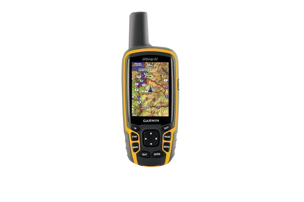
Garmin GPSMAP 62, Handheld Outdoor/Trail GPS with Maps (Garmin Certified Refurbished)
Garmin GPSMAP 62, Handheld Outdoor/Trail GPS with Maps (Garmin Certified Refurbished)
Model Number: 010-N0868-00
Out of stock
 WhatsApp
 SMS - Text us!
 Email Us!
 Help Desk

Tech Specs
Garmin GPSMAP 62 Handheld GPS Device with Topographic Maps and Geocaching Support
Introduction
The Garmin GPSMAP 62 is a quad helix antenna-equipped handheld GPS receiver built for serious trail navigation and outdoor exploration. With a high-sensitivity receiver that achieves 3-5 meter location accuracy even in dense foliage, this device eliminates guesswork when navigating challenging terrain. The combination of precise satellite acquisition, expandable mapping options, and 20-hour battery endurance makes this handheld GPS a dependable companion for backcountry trekking, geocaching expeditions, and multi-day outdoor pursuits where navigation reliability directly impacts safety and success.
Key Features
- Quad helix antenna with WAAS-enabled GPS receiver for precise positioning in dense forest canopy and open terrain
- 1.7 GB onboard memory enabling storage of multiple topographic, marine, and road map sets for worldwide navigation
- Location accuracy rating of 3-5 meters under standard operating conditions, even in challenging environmental conditions
- Battery runtime of up to 20 hours per charge, supporting extended backcountry expeditions without recharge cycles
- IPX7 water resistance rating, protecting against submersion in up to 1 meter of water for 30 minutes
- Built-in worldwide basemap with shaded relief for immediate off-the-shelf navigation capability
- GPX file compatibility for direct download of geocache coordinates and waypoint data
- Photo navigation integration with Garmin Connect™ to locate and navigate to previously uploaded images
Data Insights
The GPSMAP 62's quad helix antenna design delivers 3-5 meter positional accuracy in real-world conditions, making it viable for trail navigation where margin of error directly affects route planning. The 20-hour battery life addresses a critical pain point in multi-day backcountry trips—most competing handheld units drop to 12-15 hours under continuous GPS usage. With 1.7 GB of expandable memory, users can store both detailed topographic maps covering multiple regions and high-resolution road maps for mixed terrain navigation, eliminating the need for device swaps mid-expedition.
Usage Instructions
Charge the device fully before departure. Power on and allow 30-60 seconds for satellite acquisition in open sky conditions; denser forest coverage may require additional time. Select your desired map layer from the onboard basemap or pre-loaded microSD card maps via the menu interface. Enable the geocaching feature if pursuing cache coordinates, and use the waypoint function to mark trail intersections, camp locations, or emergency exit points. Review your planned route using BaseCamp software before deployment to identify problematic terrain and confirm map coverage across your intended navigation area.
Design and Material
The GPSMAP 62 combines tactical durability with practical field ergonomics. Its rugged exterior withstands impact, abrasion, and weather exposure typical of trail use, while the lightweight compact form factor prevents pack weight penalty on multi-day expeditions. The high-resolution color display remains readable in direct sunlight and low-light conditions, a critical feature for early-morning departures and pre-dawn navigation. Button placement and menu structure prioritize accessibility with gloved hands, essential for cold-weather and alpine trekking.
- Rubberized exterior housing rated IPX7 for water resistance without compromising tactile feedback or grip security
- Compact 2.6-inch color display with anti-glare coating for visibility across brightness extremes encountered in outdoor environments
- Physical button layout designed for single-handed operation and quick access to power, navigation, and menu functions
- Lightweight construction under 7 ounces enabling extended wear without fatigue during long trail days
- Antenna design integrated into housing to eliminate protrusions that snag on pack straps or brush
- Hardware compatibility with optional external antennas and marine transducers for specialized navigation applications
Final Verdict
The Garmin GPSMAP 62 is purpose-built for explorers who depend on GPS functionality to navigate terrain beyond marked trails. Its combination of proven receiver architecture, extended battery endurance, and robust physical design addresses the three factors that determine handheld GPS reliability in the field: accuracy under stress, sustained operation without resupply, and durability against real-world impact. Whether you navigate using topographic maps, geocache coordinates, or personal waypoints, the GPSMAP 62 delivers the precision and dependability required for confident off-trail navigation. If you routinely venture into areas where trail signs disappear and cell coverage fails, this device eliminates navigation guesswork and supports safer, more efficient route planning. Order the Garmin GPSMAP 62 today and navigate with verifiable accuracy.
In The Box
- GPSMAP 62
- Wrist strap
- USB cable
- Manual
Do you have an old GPS unit lying around? The GPS Nation Trade In and Up program is a great way to trade in your old and used GPS for credit towards a new GPS. The choice is entirely yours! We’ve made the process simple and streamlined. Follow these simple steps, and you will be on your way to receiving credit towards your brand new GPS!
1. Get a quote
To get your free quote, provide your GPS type, manufacturer, model, and condition. Within 24 hours, you will receive a quote for the trade-in value of your current product. The GPS trade-in/trade-up form is at the bottom of this page.
2. Ship your product(s) for trade
After accepting our offer, pack your product(s) safely and ship them to us using the pre-paid shipping label provided to you. We will provide a confirmation email when your trade-in arrives at our warehouse. You have 30 days from the date you complete your on-line trade to ship the product to GPS Nation.
3. Make your purchase
Once we receive your product at our warehouse and we validate the stated condition, we will send you a confirmation email. If you elect to receive credit towards a new GPS at gpsnation.com, your store credit will be issued, and you are free to make your purchase.
Manual & Warranty
 Garmin Warranty
Reviews
Ask a Question
Tech Specs
Garmin GPSMAP 62 Handheld GPS Device with Topographic Maps and Geocaching Support
Introduction
The Garmin GPSMAP 62 is a quad helix antenna-equipped handheld GPS receiver built for serious trail navigation and outdoor exploration. With a high-sensitivity receiver that achieves 3-5 meter location accuracy even in dense foliage, this device eliminates guesswork when navigating challenging terrain. The combination of precise satellite acquisition, expandable mapping options, and 20-hour battery endurance makes this handheld GPS a dependable companion for backcountry trekking, geocaching expeditions, and multi-day outdoor pursuits where navigation reliability directly impacts safety and success.
Key Features
- Quad helix antenna with WAAS-enabled GPS receiver for precise positioning in dense forest canopy and open terrain
- 1.7 GB onboard memory enabling storage of multiple topographic, marine, and road map sets for worldwide navigation
- Location accuracy rating of 3-5 meters under standard operating conditions, even in challenging environmental conditions
- Battery runtime of up to 20 hours per charge, supporting extended backcountry expeditions without recharge cycles
- IPX7 water resistance rating, protecting against submersion in up to 1 meter of water for 30 minutes
- Built-in worldwide basemap with shaded relief for immediate off-the-shelf navigation capability
- GPX file compatibility for direct download of geocache coordinates and waypoint data
- Photo navigation integration with Garmin Connect™ to locate and navigate to previously uploaded images
Data Insights
The GPSMAP 62's quad helix antenna design delivers 3-5 meter positional accuracy in real-world conditions, making it viable for trail navigation where margin of error directly affects route planning. The 20-hour battery life addresses a critical pain point in multi-day backcountry trips—most competing handheld units drop to 12-15 hours under continuous GPS usage. With 1.7 GB of expandable memory, users can store both detailed topographic maps covering multiple regions and high-resolution road maps for mixed terrain navigation, eliminating the need for device swaps mid-expedition.
Usage Instructions
Charge the device fully before departure. Power on and allow 30-60 seconds for satellite acquisition in open sky conditions; denser forest coverage may require additional time. Select your desired map layer from the onboard basemap or pre-loaded microSD card maps via the menu interface. Enable the geocaching feature if pursuing cache coordinates, and use the waypoint function to mark trail intersections, camp locations, or emergency exit points. Review your planned route using BaseCamp software before deployment to identify problematic terrain and confirm map coverage across your intended navigation area.
Design and Material
The GPSMAP 62 combines tactical durability with practical field ergonomics. Its rugged exterior withstands impact, abrasion, and weather exposure typical of trail use, while the lightweight compact form factor prevents pack weight penalty on multi-day expeditions. The high-resolution color display remains readable in direct sunlight and low-light conditions, a critical feature for early-morning departures and pre-dawn navigation. Button placement and menu structure prioritize accessibility with gloved hands, essential for cold-weather and alpine trekking.
- Rubberized exterior housing rated IPX7 for water resistance without compromising tactile feedback or grip security
- Compact 2.6-inch color display with anti-glare coating for visibility across brightness extremes encountered in outdoor environments
- Physical button layout designed for single-handed operation and quick access to power, navigation, and menu functions
- Lightweight construction under 7 ounces enabling extended wear without fatigue during long trail days
- Antenna design integrated into housing to eliminate protrusions that snag on pack straps or brush
- Hardware compatibility with optional external antennas and marine transducers for specialized navigation applications
Final Verdict
The Garmin GPSMAP 62 is purpose-built for explorers who depend on GPS functionality to navigate terrain beyond marked trails. Its combination of proven receiver architecture, extended battery endurance, and robust physical design addresses the three factors that determine handheld GPS reliability in the field: accuracy under stress, sustained operation without resupply, and durability against real-world impact. Whether you navigate using topographic maps, geocache coordinates, or personal waypoints, the GPSMAP 62 delivers the precision and dependability required for confident off-trail navigation. If you routinely venture into areas where trail signs disappear and cell coverage fails, this device eliminates navigation guesswork and supports safer, more efficient route planning. Order the Garmin GPSMAP 62 today and navigate with verifiable accuracy.
In The Box
- GPSMAP 62
- Wrist strap
- USB cable
- Manual
Trade-In
Do you have an old GPS unit lying around? The GPS Nation Trade In and Up program is a great way to trade in your old and used GPS for credit towards a new GPS. The choice is entirely yours! We’ve made the process simple and streamlined. Follow these simple steps, and you will be on your way to receiving credit towards your brand new GPS!
1. Get a quote
To get your free quote, provide your GPS type, manufacturer, model, and condition. Within 24 hours, you will receive a quote for the trade-in value of your current product. The GPS trade-in/trade-up form is at the bottom of this page.
2. Ship your product(s) for trade
After accepting our offer, pack your product(s) safely and ship them to us using the pre-paid shipping label provided to you. We will provide a confirmation email when your trade-in arrives at our warehouse. You have 30 days from the date you complete your on-line trade to ship the product to GPS Nation.
3. Make your purchase
Once we receive your product at our warehouse and we validate the stated condition, we will send you a confirmation email. If you elect to receive credit towards a new GPS at gpsnation.com, your store credit will be issued, and you are free to make your purchase.
Manual & Warranty
Overview
Garmin GPSMAP 62 Handheld GPS Device with Topographic Maps and Geocaching Support
Introduction
The Garmin GPSMAP 62 is a quad helix antenna-equipped handheld GPS receiver built for serious trail navigation and outdoor exploration. With a high-sensitivity receiver that achieves 3-5 meter location accuracy even in dense foliage, this device eliminates guesswork when navigating challenging terrain. The combination of precise satellite acquisition, expandable mapping options, and 20-hour battery endurance makes this handheld GPS a dependable companion for backcountry trekking, geocaching expeditions, and multi-day outdoor pursuits where navigation reliability directly impacts safety and success.
Key Features
- Quad helix antenna with WAAS-enabled GPS receiver for precise positioning in dense forest canopy and open terrain
- 1.7 GB onboard memory enabling storage of multiple topographic, marine, and road map sets for worldwide navigation
- Location accuracy rating of 3-5 meters under standard operating conditions, even in challenging environmental conditions
- Battery runtime of up to 20 hours per charge, supporting extended backcountry expeditions without recharge cycles
- IPX7 water resistance rating, protecting against submersion in up to 1 meter of water for 30 minutes
- Built-in worldwide basemap with shaded relief for immediate off-the-shelf navigation capability
- GPX file compatibility for direct download of geocache coordinates and waypoint data
- Photo navigation integration with Garmin Connect™ to locate and navigate to previously uploaded images
Data Insights
The GPSMAP 62's quad helix antenna design delivers 3-5 meter positional accuracy in real-world conditions, making it viable for trail navigation where margin of error directly affects route planning. The 20-hour battery life addresses a critical pain point in multi-day backcountry trips—most competing handheld units drop to 12-15 hours under continuous GPS usage. With 1.7 GB of expandable memory, users can store both detailed topographic maps covering multiple regions and high-resolution road maps for mixed terrain navigation, eliminating the need for device swaps mid-expedition.
Usage Instructions
Charge the device fully before departure. Power on and allow 30-60 seconds for satellite acquisition in open sky conditions; denser forest coverage may require additional time. Select your desired map layer from the onboard basemap or pre-loaded microSD card maps via the menu interface. Enable the geocaching feature if pursuing cache coordinates, and use the waypoint function to mark trail intersections, camp locations, or emergency exit points. Review your planned route using BaseCamp software before deployment to identify problematic terrain and confirm map coverage across your intended navigation area.
Design and Material
The GPSMAP 62 combines tactical durability with practical field ergonomics. Its rugged exterior withstands impact, abrasion, and weather exposure typical of trail use, while the lightweight compact form factor prevents pack weight penalty on multi-day expeditions. The high-resolution color display remains readable in direct sunlight and low-light conditions, a critical feature for early-morning departures and pre-dawn navigation. Button placement and menu structure prioritize accessibility with gloved hands, essential for cold-weather and alpine trekking.
- Rubberized exterior housing rated IPX7 for water resistance without compromising tactile feedback or grip security
- Compact 2.6-inch color display with anti-glare coating for visibility across brightness extremes encountered in outdoor environments
- Physical button layout designed for single-handed operation and quick access to power, navigation, and menu functions
- Lightweight construction under 7 ounces enabling extended wear without fatigue during long trail days
- Antenna design integrated into housing to eliminate protrusions that snag on pack straps or brush
- Hardware compatibility with optional external antennas and marine transducers for specialized navigation applications
Final Verdict
The Garmin GPSMAP 62 is purpose-built for explorers who depend on GPS functionality to navigate terrain beyond marked trails. Its combination of proven receiver architecture, extended battery endurance, and robust physical design addresses the three factors that determine handheld GPS reliability in the field: accuracy under stress, sustained operation without resupply, and durability against real-world impact. Whether you navigate using topographic maps, geocache coordinates, or personal waypoints, the GPSMAP 62 delivers the precision and dependability required for confident off-trail navigation. If you routinely venture into areas where trail signs disappear and cell coverage fails, this device eliminates navigation guesswork and supports safer, more efficient route planning. Order the Garmin GPSMAP 62 today and navigate with verifiable accuracy.


