


Garmin GPSMAP 742xs (010-01738-03)
Garmin GPSMAP 742xs (010-01738-03)
Model Number: 010-01738-03
Out of stock
 WhatsApp
 SMS - Text us!
 Email Us!
 Help Desk

Tech Specs
Garmin GPSMAP 742xs Marine Chartplotter and Sonar Combo
Introduction
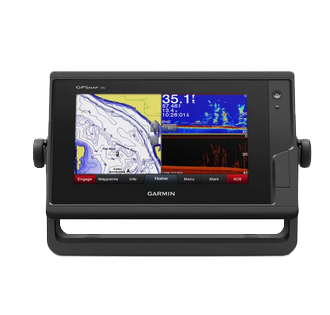
The Garmin GPSMAP 742xs combines a high-resolution 7-inch touchscreen chartplotter with integrated dual-channel sonar in a single marine-grade unit designed for inland and coastal boating. The 10 Hz GPS and GLONASS receiver updates your position and heading ten times per second, delivering the real-time precision needed for accurate navigation across lakes and open water. Built-in Wi-Fi connectivity bridges your vessel to the ActiveCaptain community platform, enabling chart updates and navigation data sharing without docking.
Key Features
- 10 Hz GPS and GLONASS receiver refreshes position and heading 10 times per second for smooth, responsive navigation
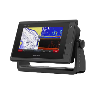
- 1 kW CHIRP sonar with CHIRP ClearVü scanning sonar technology for detailed underwater structure visualization
- 7-inch high-resolution color touchscreen with daylight-readable display and multi-window layout capability
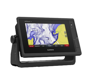
- Preloaded LakeVü g3 inland mapping with 1-foot contour intervals via Quickdraw Contours feature
- BlueChart g3 coastal and world charts included for comprehensive saltwater and international navigation
- Built-in Wi-Fi and NMEA 2000 networking for seamless connectivity with other marine electronics and mobile devices
- SailAssist functionality providing pre-race guidance and competitive sailing data fields
Data Insights
The GPSMAP 742xs delivers up to 40 percent faster route recalculation speeds compared to previous generation chartplotters, translating to quicker course corrections when conditions change or waypoints are adjusted. The 10 Hz refresh rate provides significantly smoother track recording and heading display than standard 1 Hz systems, reducing lag during tight maneuvers or high-speed navigation. This performance level positions the unit among the faster processing marine chartplotters in its class for both recreational and serious boating applications.
Usage Instructions
Mount the GPSMAP 742xs where the GPS antenna has an unobstructed view of the sky, away from metal structures that could block satellite signals. Power the unit and allow it to acquire GPS and GLONASS satellite locks before beginning navigation—this typically takes 2 to 5 minutes on initial startup. Use the responsive touchscreen to navigate menus, set waypoints, view sonar returns, and customize display preferences. Connect via Wi-Fi to download chart updates and access community fishing data through ActiveCaptain without requiring a computer connection.
Design and Material
The GPSMAP 742xs is engineered for the marine environment with corrosion-resistant housing and sealed connectors that protect internal components from saltwater spray and moisture. The compact, rectangular form factor fits standard 1- and 2-DIN flush-mount applications while remaining lightweight enough for portable deployment on smaller vessels. The intuitive touchscreen interface minimizes the learning curve for boaters transitioning from traditional paper charts.
- Corrosion-resistant marine-grade housing withstands saltwater exposure and high-humidity conditions
- 7-inch color touchscreen with anti-glare coating and full brightness output readable in direct sunlight
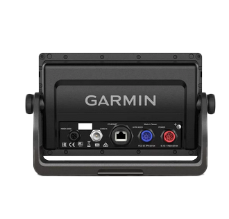
- Integrated transducer connector supports dual-channel sonar hardware with single-cable installation
- Compact 6.9-inch wide form factor designed for standard marine mounting brackets and dash openings
- Sealed cable connectors and power port prevent water ingress during extended use in wet conditions
- Lightweight construction reduces installation complexity and works with boats ranging from center console to cruising sailboats
Final Verdict
The Garmin GPSMAP 742xs merges navigation, fishfinding, and connectivity into a single reliable instrument built specifically for marine environments where precision and durability are non-negotiable. The combination of dual sonar channels, preloaded detailed charts for both inland and coastal waters, and real-time community data access makes it a practical choice for boaters who demand performance across varied water conditions. If your boating demands accurate positioning, detailed underwater mapping, and seamless connectivity between your vessel and the latest navigation technology, the GPSMAP 742xs delivers on all counts. Equip your boat with this marine-proven chartplotter and sonar combo to navigate with confidence on your next outing.
In The Box
- GPSMAP 742xs chartplotter
- Power cable
- Bail mount kit with knobs
- Flush mount kit with gasket
- Protective cover
- Trim piece snap covers
- Documentation
Do you have an old GPS unit lying around? The GPS Nation Trade In and Up program is a great way to trade in your old and used GPS for credit towards a new GPS. The choice is entirely yours! We’ve made the process simple and streamlined. Follow these simple steps, and you will be on your way to receiving credit towards your brand new GPS!
1. Get a quote
To get your free quote, provide your GPS type, manufacturer, model, and condition. Within 24 hours, you will receive a quote for the trade-in value of your current product. The GPS trade-in/trade-up form is at the bottom of this page.
2. Ship your product(s) for trade
After accepting our offer, pack your product(s) safely and ship them to us using the pre-paid shipping label provided to you. We will provide a confirmation email when your trade-in arrives at our warehouse. You have 30 days from the date you complete your on-line trade to ship the product to GPS Nation.
3. Make your purchase
Once we receive your product at our warehouse and we validate the stated condition, we will send you a confirmation email. If you elect to receive credit towards a new GPS at gpsnation.com, your store credit will be issued, and you are free to make your purchase.
Manual & Warranty
 Garmin Warranty
Reviews
Ask a Question
Tech Specs
Garmin GPSMAP 742xs Marine Chartplotter and Sonar Combo
Introduction
The Garmin GPSMAP 742xs combines a high-resolution 7-inch touchscreen chartplotter with integrated dual-channel sonar in a single marine-grade unit designed for inland and coastal boating. The 10 Hz GPS and GLONASS receiver updates your position and heading ten times per second, delivering the real-time precision needed for accurate navigation across lakes and open water. Built-in Wi-Fi connectivity bridges your vessel to the ActiveCaptain community platform, enabling chart updates and navigation data sharing without docking.
Key Features
- 10 Hz GPS and GLONASS receiver refreshes position and heading 10 times per second for smooth, responsive navigation
- 1 kW CHIRP sonar with CHIRP ClearVü scanning sonar technology for detailed underwater structure visualization
- 7-inch high-resolution color touchscreen with daylight-readable display and multi-window layout capability
- Preloaded LakeVü g3 inland mapping with 1-foot contour intervals via Quickdraw Contours feature
- BlueChart g3 coastal and world charts included for comprehensive saltwater and international navigation
- Built-in Wi-Fi and NMEA 2000 networking for seamless connectivity with other marine electronics and mobile devices
- SailAssist functionality providing pre-race guidance and competitive sailing data fields
Data Insights
The GPSMAP 742xs delivers up to 40 percent faster route recalculation speeds compared to previous generation chartplotters, translating to quicker course corrections when conditions change or waypoints are adjusted. The 10 Hz refresh rate provides significantly smoother track recording and heading display than standard 1 Hz systems, reducing lag during tight maneuvers or high-speed navigation. This performance level positions the unit among the faster processing marine chartplotters in its class for both recreational and serious boating applications.
Usage Instructions
Mount the GPSMAP 742xs where the GPS antenna has an unobstructed view of the sky, away from metal structures that could block satellite signals. Power the unit and allow it to acquire GPS and GLONASS satellite locks before beginning navigation—this typically takes 2 to 5 minutes on initial startup. Use the responsive touchscreen to navigate menus, set waypoints, view sonar returns, and customize display preferences. Connect via Wi-Fi to download chart updates and access community fishing data through ActiveCaptain without requiring a computer connection.
Design and Material
The GPSMAP 742xs is engineered for the marine environment with corrosion-resistant housing and sealed connectors that protect internal components from saltwater spray and moisture. The compact, rectangular form factor fits standard 1- and 2-DIN flush-mount applications while remaining lightweight enough for portable deployment on smaller vessels. The intuitive touchscreen interface minimizes the learning curve for boaters transitioning from traditional paper charts.
- Corrosion-resistant marine-grade housing withstands saltwater exposure and high-humidity conditions
- 7-inch color touchscreen with anti-glare coating and full brightness output readable in direct sunlight
- Integrated transducer connector supports dual-channel sonar hardware with single-cable installation
- Compact 6.9-inch wide form factor designed for standard marine mounting brackets and dash openings
- Sealed cable connectors and power port prevent water ingress during extended use in wet conditions
- Lightweight construction reduces installation complexity and works with boats ranging from center console to cruising sailboats
Final Verdict
The Garmin GPSMAP 742xs merges navigation, fishfinding, and connectivity into a single reliable instrument built specifically for marine environments where precision and durability are non-negotiable. The combination of dual sonar channels, preloaded detailed charts for both inland and coastal waters, and real-time community data access makes it a practical choice for boaters who demand performance across varied water conditions. If your boating demands accurate positioning, detailed underwater mapping, and seamless connectivity between your vessel and the latest navigation technology, the GPSMAP 742xs delivers on all counts. Equip your boat with this marine-proven chartplotter and sonar combo to navigate with confidence on your next outing.
In The Box
- GPSMAP 742xs chartplotter
- Power cable
- Bail mount kit with knobs
- Flush mount kit with gasket
- Protective cover
- Trim piece snap covers
- Documentation
Trade-In
Do you have an old GPS unit lying around? The GPS Nation Trade In and Up program is a great way to trade in your old and used GPS for credit towards a new GPS. The choice is entirely yours! We’ve made the process simple and streamlined. Follow these simple steps, and you will be on your way to receiving credit towards your brand new GPS!
1. Get a quote
To get your free quote, provide your GPS type, manufacturer, model, and condition. Within 24 hours, you will receive a quote for the trade-in value of your current product. The GPS trade-in/trade-up form is at the bottom of this page.
2. Ship your product(s) for trade
After accepting our offer, pack your product(s) safely and ship them to us using the pre-paid shipping label provided to you. We will provide a confirmation email when your trade-in arrives at our warehouse. You have 30 days from the date you complete your on-line trade to ship the product to GPS Nation.
3. Make your purchase
Once we receive your product at our warehouse and we validate the stated condition, we will send you a confirmation email. If you elect to receive credit towards a new GPS at gpsnation.com, your store credit will be issued, and you are free to make your purchase.
Manual & Warranty
Overview
Garmin GPSMAP 742xs Marine Chartplotter and Sonar Combo
Introduction
The Garmin GPSMAP 742xs combines a high-resolution 7-inch touchscreen chartplotter with integrated dual-channel sonar in a single marine-grade unit designed for inland and coastal boating. The 10 Hz GPS and GLONASS receiver updates your position and heading ten times per second, delivering the real-time precision needed for accurate navigation across lakes and open water. Built-in Wi-Fi connectivity bridges your vessel to the ActiveCaptain community platform, enabling chart updates and navigation data sharing without docking.
Key Features
- 10 Hz GPS and GLONASS receiver refreshes position and heading 10 times per second for smooth, responsive navigation
- 1 kW CHIRP sonar with CHIRP ClearVü scanning sonar technology for detailed underwater structure visualization
- 7-inch high-resolution color touchscreen with daylight-readable display and multi-window layout capability
- Preloaded LakeVü g3 inland mapping with 1-foot contour intervals via Quickdraw Contours feature
- BlueChart g3 coastal and world charts included for comprehensive saltwater and international navigation
- Built-in Wi-Fi and NMEA 2000 networking for seamless connectivity with other marine electronics and mobile devices
- SailAssist functionality providing pre-race guidance and competitive sailing data fields
Data Insights
The GPSMAP 742xs delivers up to 40 percent faster route recalculation speeds compared to previous generation chartplotters, translating to quicker course corrections when conditions change or waypoints are adjusted. The 10 Hz refresh rate provides significantly smoother track recording and heading display than standard 1 Hz systems, reducing lag during tight maneuvers or high-speed navigation. This performance level positions the unit among the faster processing marine chartplotters in its class for both recreational and serious boating applications.
Usage Instructions
Mount the GPSMAP 742xs where the GPS antenna has an unobstructed view of the sky, away from metal structures that could block satellite signals. Power the unit and allow it to acquire GPS and GLONASS satellite locks before beginning navigation—this typically takes 2 to 5 minutes on initial startup. Use the responsive touchscreen to navigate menus, set waypoints, view sonar returns, and customize display preferences. Connect via Wi-Fi to download chart updates and access community fishing data through ActiveCaptain without requiring a computer connection.
Design and Material
The GPSMAP 742xs is engineered for the marine environment with corrosion-resistant housing and sealed connectors that protect internal components from saltwater spray and moisture. The compact, rectangular form factor fits standard 1- and 2-DIN flush-mount applications while remaining lightweight enough for portable deployment on smaller vessels. The intuitive touchscreen interface minimizes the learning curve for boaters transitioning from traditional paper charts.
- Corrosion-resistant marine-grade housing withstands saltwater exposure and high-humidity conditions
- 7-inch color touchscreen with anti-glare coating and full brightness output readable in direct sunlight
- Integrated transducer connector supports dual-channel sonar hardware with single-cable installation
- Compact 6.9-inch wide form factor designed for standard marine mounting brackets and dash openings
- Sealed cable connectors and power port prevent water ingress during extended use in wet conditions
- Lightweight construction reduces installation complexity and works with boats ranging from center console to cruising sailboats
Final Verdict
The Garmin GPSMAP 742xs merges navigation, fishfinding, and connectivity into a single reliable instrument built specifically for marine environments where precision and durability are non-negotiable. The combination of dual sonar channels, preloaded detailed charts for both inland and coastal waters, and real-time community data access makes it a practical choice for boaters who demand performance across varied water conditions. If your boating demands accurate positioning, detailed underwater mapping, and seamless connectivity between your vessel and the latest navigation technology, the GPSMAP 742xs delivers on all counts. Equip your boat with this marine-proven chartplotter and sonar combo to navigate with confidence on your next outing.


