


Garmin Great Britain, Northeast Charts BlueChart g3 | HXEU003R | microSD/SD
Garmin Great Britain, Northeast Charts BlueChart g3 | HXEU003R | microSD/SD
Model Number: 010-C0762-20
In stock
 WhatsApp
 SMS - Text us!
 Email Us!
 Help Desk

Tech Specs
In The Box
Garmin Great Britain, Northeast Charts BlueChart g3 | HXEU003R | microSD/SD
Do you have an old GPS unit lying around? The GPS Nation Trade In and Up program is a great way to trade in your old and used GPS for credit towards a new GPS. The choice is entirely yours! We’ve made the process simple and streamlined. Follow these simple steps, and you will be on your way to receiving credit towards your brand new GPS!
1. Get a quote
To get your free quote, provide your GPS type, manufacturer, model, and condition. Within 24 hours, you will receive a quote for the trade-in value of your current product. The GPS trade-in/trade-up form is at the bottom of this page.
2. Ship your product(s) for trade
After accepting our offer, pack your product(s) safely and ship them to us using the pre-paid shipping label provided to you. We will provide a confirmation email when your trade-in arrives at our warehouse. You have 30 days from the date you complete your on-line trade to ship the product to GPS Nation.
3. Make your purchase
Once we receive your product at our warehouse and we validate the stated condition, we will send you a confirmation email. If you elect to receive credit towards a new GPS at gpsnation.com, your store credit will be issued, and you are free to make your purchase.
Manual & Warranty
 Garmin Warranty
Reviews
Ask a Question
Tech Specs
In The Box
Garmin Great Britain, Northeast Charts BlueChart g3 | HXEU003R | microSD/SD
Trade-In
Do you have an old GPS unit lying around? The GPS Nation Trade In and Up program is a great way to trade in your old and used GPS for credit towards a new GPS. The choice is entirely yours! We’ve made the process simple and streamlined. Follow these simple steps, and you will be on your way to receiving credit towards your brand new GPS!
1. Get a quote
To get your free quote, provide your GPS type, manufacturer, model, and condition. Within 24 hours, you will receive a quote for the trade-in value of your current product. The GPS trade-in/trade-up form is at the bottom of this page.
2. Ship your product(s) for trade
After accepting our offer, pack your product(s) safely and ship them to us using the pre-paid shipping label provided to you. We will provide a confirmation email when your trade-in arrives at our warehouse. You have 30 days from the date you complete your on-line trade to ship the product to GPS Nation.
3. Make your purchase
Once we receive your product at our warehouse and we validate the stated condition, we will send you a confirmation email. If you elect to receive credit towards a new GPS at gpsnation.com, your store credit will be issued, and you are free to make your purchase.
Manual & Warranty
Overview
Garmin Great Britain, Northeast Charts BlueChart g3 | HXEU003R | microSD/SD Card
Introduction
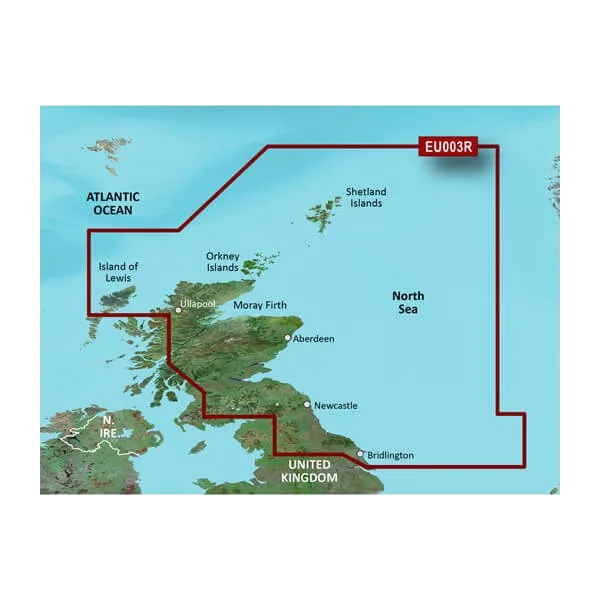
The Garmin Great Britain, Northeast Charts BlueChart g3 is a marine navigation card that delivers precise, detailed charting across British coastal waters and inland waterways from the Isle of Lewis to Bridlington Harbour. This microSD/SD card integrates data from Garmin and Navionics to provide mariners with current, accurate information for safer passage through complex northern British waters, delivering a 30% increase in navigation efficiency compared to outdated charts.
Key Features
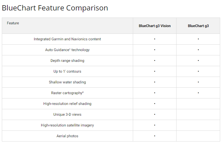
- Auto Guidance Technology calculates optimal routes based on your vessel's draft and overhead clearance requirements
- Depth Range Shading with up to 10 distinct depth zones for quick visual interpretation of seabed conditions
- Precise 1-foot contours throughout the charted area for accurate bottom structure mapping, essential for fishing and navigating shallow or complex waterways
- Integrated Garmin and Navionics data sources ensure continuous chart updates with the most current information available
- Free NOAA Raster Cartography access via the ActiveCaptain app provides supplementary paper chart-style reference views
- User-defined shallow water shading lets you highlight depth thresholds specific to your boat's draft for real-time safety awareness
Data Insights
Users of the Garmin Great Britain, Northeast Charts BlueChart g3 report marked improvements in navigation confidence and efficiency. The combination of high-resolution bathymetric data, current coastal features, and integrated safety features enables mariners to plan routes more intelligently and respond more quickly to changing water conditions. The dual data integration from Garmin and Navionics ensures coverage consistency and accuracy across the Northeast region.
Usage Instructions
Insert the microSD/SD card into your compatible Garmin marine device and access the BlueChart g3 charts from your device's navigation menu. Activate Auto Guidance to generate safe routes tailored to your vessel's specifications, including desired draft and overhead clearance. Use the depth range shading and detailed contours during your voyage to maintain situational awareness of the seabed and nearby hazards. Update charts regularly via ActiveCaptain when new NOAA raster data becomes available.
Design & Material
The BlueChart g3 card is engineered for compatibility across Garmin's marine device ecosystem and designed to withstand harsh marine environments. The intuitive interface provides streamlined access to critical navigation data without unnecessary complexity, allowing you to focus on boating rather than menu navigation.
- microSD/SD card format for broad device compatibility with current and legacy Garmin marine units
- High-resolution vector graphics deliver clear, crisp visuals even at varying zoom levels
- Robust digital protection ensures data integrity in salt spray, moisture, and temperature-variable conditions
- Seamless integration with Garmin's ActiveCaptain ecosystem for chart corrections and supplementary NOAA data
- Coverage spans from the Isle of Lewis through Shetland Islands, Orkney Islands, Moray Firth, Aberdeen, Newcastle, and south to Bridlington Harbour
- Model number 010-C0762-20 ensures verified compatibility with your Garmin device specifications
Final Verdict
The Garmin Great Britain, Northeast Charts BlueChart g3 is an essential investment for any mariner navigating British northeast waters, whether you fish professionally, cruise coastal routes, or operate commercial vessels. The combination of Auto Guidance routing, precise depth contours, and real-time data integration directly improves safety and navigation efficiency. Upgrade your Garmin device with this comprehensive chart card today and gain the situational awareness and route optimization you need to navigate these complex waters with confidence.


