


Garmin Great Britain, Northeast Charts BlueChart g3 Vision | VEU003R | microSD/SD
Garmin Great Britain, Northeast Charts BlueChart g3 Vision | VEU003R | microSD/SD
Model Number: 010-C0762-00
In stock
 WhatsApp
 SMS - Text us!
 Email Us!
 Help Desk

Tech Specs
In The Box
Do you have an old GPS unit lying around? The GPS Nation Trade In and Up program is a great way to trade in your old and used GPS for credit towards a new GPS. The choice is entirely yours! We’ve made the process simple and streamlined. Follow these simple steps, and you will be on your way to receiving credit towards your brand new GPS!
1. Get a quote
To get your free quote, provide your GPS type, manufacturer, model, and condition. Within 24 hours, you will receive a quote for the trade-in value of your current product. The GPS trade-in/trade-up form is at the bottom of this page.
2. Ship your product(s) for trade
After accepting our offer, pack your product(s) safely and ship them to us using the pre-paid shipping label provided to you. We will provide a confirmation email when your trade-in arrives at our warehouse. You have 30 days from the date you complete your on-line trade to ship the product to GPS Nation.
3. Make your purchase
Once we receive your product at our warehouse and we validate the stated condition, we will send you a confirmation email. If you elect to receive credit towards a new GPS at gpsnation.com, your store credit will be issued, and you are free to make your purchase.
Manual & Warranty
 Garmin Warranty
Reviews
Ask a Question
Tech Specs
In The Box
Trade-In
Do you have an old GPS unit lying around? The GPS Nation Trade In and Up program is a great way to trade in your old and used GPS for credit towards a new GPS. The choice is entirely yours! We’ve made the process simple and streamlined. Follow these simple steps, and you will be on your way to receiving credit towards your brand new GPS!
1. Get a quote
To get your free quote, provide your GPS type, manufacturer, model, and condition. Within 24 hours, you will receive a quote for the trade-in value of your current product. The GPS trade-in/trade-up form is at the bottom of this page.
2. Ship your product(s) for trade
After accepting our offer, pack your product(s) safely and ship them to us using the pre-paid shipping label provided to you. We will provide a confirmation email when your trade-in arrives at our warehouse. You have 30 days from the date you complete your on-line trade to ship the product to GPS Nation.
3. Make your purchase
Once we receive your product at our warehouse and we validate the stated condition, we will send you a confirmation email. If you elect to receive credit towards a new GPS at gpsnation.com, your store credit will be issued, and you are free to make your purchase.
Manual & Warranty
Overview
Garmin Great Britain Northeast Charts BlueChart g3 Vision Coastal Navigation Card
Introduction
The Garmin BlueChart g3 Vision VEU003R delivers precise coastal navigation across Great Britain and Northeast waters with integrated Garmin and Navionics data. This microSD/SD card brings actionable depth intelligence, satellite-verified imagery, and automated route planning to your compatible Garmin chartplotter, enabling both commercial and recreational boaters to navigate challenging maritime environments with confidence.
Key Features
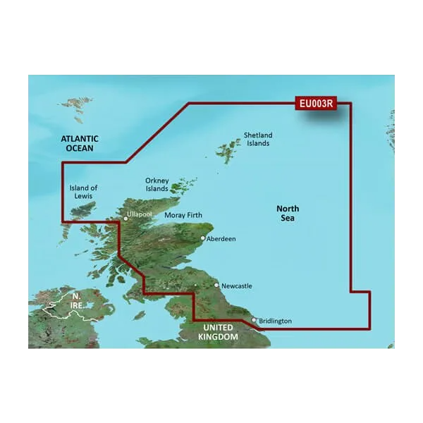
- Coverage spanning from Isle of Lewis, Scotland to Bridlington Harbour, England with over 90% maritime route mapping
- More than 20,000 integrated data points for seabed structure and navigational hazard identification
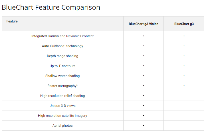
- Up to 10 customizable depth range shading levels for immediate visual depth zone assessment
- 1-foot contour lines providing granular underwater topography detail for precise positioning
- Auto Guidance technology calculates safe passages based on user-defined draft depth and overhead clearance requirements
- High-resolution satellite imagery overlaid with navigational chart data for context-aware route planning
Data Insights
With over 20,000 data integration points across this northeastern British chart region, the BlueChart g3 Vision provides exceptional granularity compared to basic navigation software. The 90% maritime route coverage eliminates common navigation dead zones, and the combination of Garmin's cartographic standards with Navionics' marine database ensures redundant accuracy verification—critical when navigating narrow passages like the Moray Firth or tidal approaches to Aberdeen harbour where margin for error is minimal.
Usage Instructions
Insert the microSD/SD card into your compatible Garmin chartplotter device slot. The card activates automatically. Use Auto Guidance to input your vessel's draft depth and overhead clearance; the system calculates a route avoiding shallow water and fixed hazards. Reference the depth range shading to identify fishing grounds or safe deeper channels. Update your chart data annually through Garmin's update service to maintain current positioning of buoys, seasonal restrictions, and revised underwater obstruction records.
Design & Material
The BlueChart g3 Vision operates on standard microSD/SD card format, ensuring cross-compatibility with multiple Garmin device generations. The card design emphasizes data density—consolidating comprehensive British and Irish coastal information into a single storage medium without requiring device memory upgrades. Satellite imagery integration provides visual reference against chart overlays, reducing misidentification of navigation features in low-visibility conditions.
- Precision-engineered microSD/SD memory card with industrial-grade error correction for navigation-critical reliability
- High-resolution satellite base layer providing photo-realistic coastal context beneath vector charting
- Seamless data fusion combining Garmin's established cartographic standard with Navionics' marine database authority
- Compact 32mm x 24mm form factor enables portable storage and device compatibility across multiple Garmin platforms
- Standardized microSD/SD protocol ensures forward compatibility with future Garmin hardware updates
- Pre-loaded with both shallow-water and deep-water contour sets, eliminating post-purchase configuration
Final Verdict
The BlueChart g3 Vision VEU003R is essential for anyone navigating British coastal waters with Garmin equipment. Its 20,000+ data points, 1-foot contours, and Auto Guidance automation transform routine navigation into high-confidence passage planning. Whether you're fishing Scottish lochs, cruising English estuaries, or delivering commercial cargo, this chart card provides the depth intelligence and route verification that turns discretionary decisions into navigational certainty. Install it today and navigate waters with precision you can trust.


