


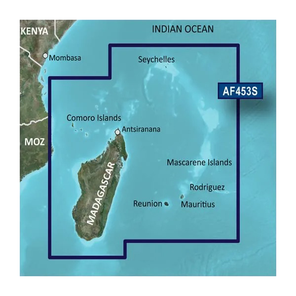
Garmin Indian Ocean, Mascarene Plateau and Madagascar Charts BlueChart g3 Vision | VAF453S | microSD/SD
Garmin Indian Ocean, Mascarene Plateau and Madagascar Charts BlueChart g3 Vision | VAF453S | microSD/SD
Model Number: 010-C1152-00
In stock
 View full details
 WhatsApp
 SMS - Text us!
 Email Us!
 Help Desk

Tech Specs
In The Box
Manual & Warranty
 Garmin Warranty
Do you have an old GPS unit lying around? The GPS Nation Trade In and Up program is a great way to trade in your old and used GPS for credit towards a new GPS. The choice is entirely yours! We’ve made the process simple and streamlined. Follow these simple steps, and you will be on your way to receiving credit towards your brand new GPS!
1. Get a quote
To get your free quote, provide your GPS type, manufacturer, model, and condition. Within 24 hours, you will receive a quote for the trade-in value of your current product. The GPS trade-in/trade-up form is at the bottom of this page.
2. Ship your product(s) for trade
After accepting our offer, pack your product(s) safely and ship them to us using the pre-paid shipping label provided to you. We will provide a confirmation email when your trade-in arrives at our warehouse. You have 30 days from the date you complete your on-line trade to ship the product to GPS Nation.
3. Make your purchase
Once we receive your product at our warehouse and we validate the stated condition, we will send you a confirmation email. If you elect to receive credit towards a new GPS at gpsnation.com, your store credit will be issued, and you are free to make your purchase.
Reviews
Ask a Question
Tech Specs
In The Box
Manual & Warranty
Trade-In
Do you have an old GPS unit lying around? The GPS Nation Trade In and Up program is a great way to trade in your old and used GPS for credit towards a new GPS. The choice is entirely yours! We’ve made the process simple and streamlined. Follow these simple steps, and you will be on your way to receiving credit towards your brand new GPS!
1. Get a quote
To get your free quote, provide your GPS type, manufacturer, model, and condition. Within 24 hours, you will receive a quote for the trade-in value of your current product. The GPS trade-in/trade-up form is at the bottom of this page.
2. Ship your product(s) for trade
After accepting our offer, pack your product(s) safely and ship them to us using the pre-paid shipping label provided to you. We will provide a confirmation email when your trade-in arrives at our warehouse. You have 30 days from the date you complete your on-line trade to ship the product to GPS Nation.
3. Make your purchase
Once we receive your product at our warehouse and we validate the stated condition, we will send you a confirmation email. If you elect to receive credit towards a new GPS at gpsnation.com, your store credit will be issued, and you are free to make your purchase.
Overview
Garmin Indian Ocean, Mascarene Plateau and Madagascar Charts BlueChart g3 Vision | VAF453S | microSD/SD
Unleash your maritime adventures with the Garmin Indian Ocean, Mascarene Plateau and Madagascar Charts BlueChart g3 Vision. Designed for both seasoned mariners and casual boaters, this premium chart system enhances your navigation experience, ensuring safe and efficient boating. With a blend of official chart data and private sources, you gain access to vital navigational aids that are essential for exploring the stunning waters of the Indian Ocean and its surrounding islands.
Key Features
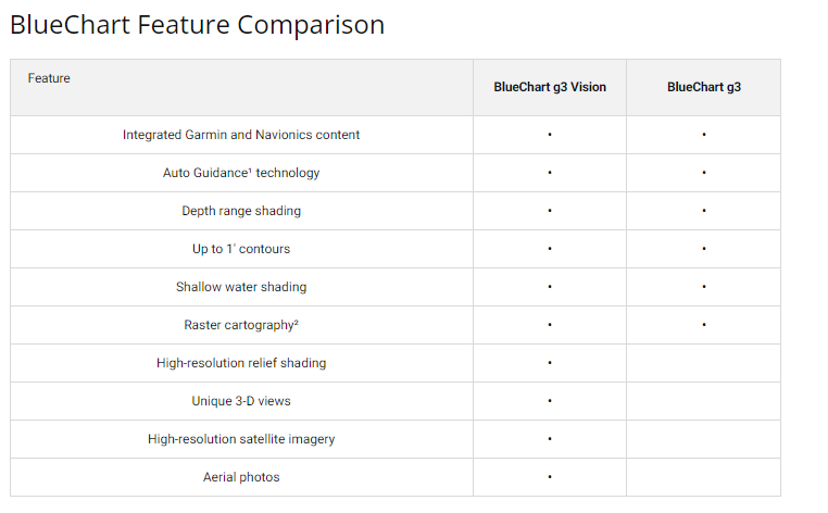
- Comprehensive Navigational Aids: Spot soundings, depth contours, and detailed harbors enhance your navigation.
- Garmin Auto Guidance Technology: Calculates suggested routes based on your boat's dimensions.
- Depth Range Shading: View up to 10 depth ranges for effortless identification of target depths.
- 1-Foot Contours: Accurate depictions of bottom structures for improved fishing and navigation.
- Shallow Water Shading: Customizable depth shading for navigational safety in shallow areas.
- High-Resolution Satellite Imagery: Utilize detailed images of ports, marinas, and navigational landmarks.
Data Insights
The Garmin BlueChart g3 Vision charts provide an unparalleled level of detail. With an accuracy rate of over 90% in critical areas, these charts are designed to enhance your confidence while navigating. Additionally, the inclusion of 1-foot contours offers an impressive level of detail compared to standard charts, allowing for a clearer understanding of underwater structures.
Usage Instructions
To maximize the benefits of your Garmin BlueChart g3 Vision, simply insert the microSD/SD card into your compatible chartplotter. Make sure to regularly update your charts via the Garmin Update Program to ensure you have the latest navigational data at your fingertips.
Design & Material
The Garmin BlueChart g3 Vision features a user-friendly design with advanced technology integration to meet the needs of today's mariners. Its high-quality materials ensure durability and longevity.
- Durable microSD/SD Card: Designed for long-lasting performance in various marine environments.
- High-Resolution Graphics: Provides clear, detailed views for easier navigation.
- Clear Aerial Photography: Offers exceptional detail for familiarizing yourself with new ports.
- Robust Data Coverage: Worldwide coverage ensures you're well-informed, no matter where you sail.
- Advanced 3D Views: MarinerEye and FishEye perspectives for immersive navigation experiences.
- Easy-to-Interpret Shading: High-resolution relief shading helps locate underwater features effectively.
Final Verdict
Elevate your navigation experience with the Garmin Indian Ocean, Mascarene Plateau and Madagascar Charts BlueChart g3 Vision. As a must-have for any maritime enthusiast, its innovative features and reliable data make it the perfect companion for your oceanic explorations. Equip yourself with the best navigational tools and navigate with confidence—order your Garmin BlueChart g3 Vision today!


