


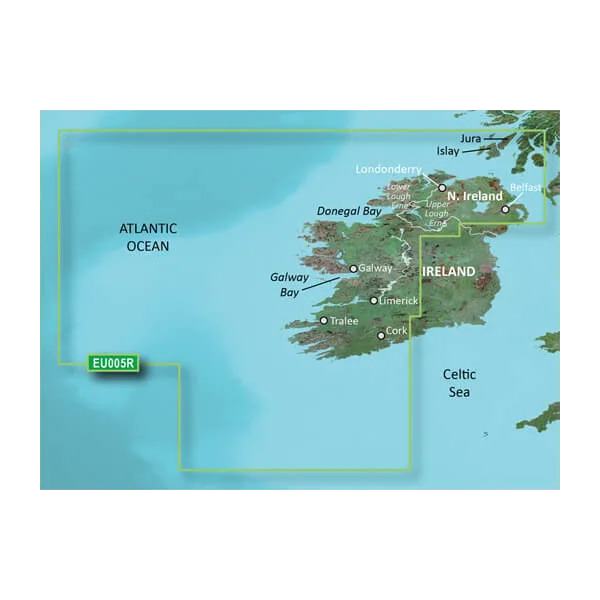
Garmin Ireland, West Coastal and Inland Charts BlueChart g3 Vision | VEU005R | microSD/SD
Garmin Ireland, West Coastal and Inland Charts BlueChart g3 Vision | VEU005R | microSD/SD
Model Number: 010-C0764-00
In stock
 View full details
 WhatsApp
 SMS - Text us!
 Email Us!
 Help Desk

Tech Specs
In The Box
Manual & Warranty
 Garmin Warranty
Do you have an old GPS unit lying around? The GPS Nation Trade In and Up program is a great way to trade in your old and used GPS for credit towards a new GPS. The choice is entirely yours! We’ve made the process simple and streamlined. Follow these simple steps, and you will be on your way to receiving credit towards your brand new GPS!
1. Get a quote
To get your free quote, provide your GPS type, manufacturer, model, and condition. Within 24 hours, you will receive a quote for the trade-in value of your current product. The GPS trade-in/trade-up form is at the bottom of this page.
2. Ship your product(s) for trade
After accepting our offer, pack your product(s) safely and ship them to us using the pre-paid shipping label provided to you. We will provide a confirmation email when your trade-in arrives at our warehouse. You have 30 days from the date you complete your on-line trade to ship the product to GPS Nation.
3. Make your purchase
Once we receive your product at our warehouse and we validate the stated condition, we will send you a confirmation email. If you elect to receive credit towards a new GPS at gpsnation.com, your store credit will be issued, and you are free to make your purchase.
Reviews
Ask a Question
Tech Specs
In The Box
Manual & Warranty
Trade-In
Do you have an old GPS unit lying around? The GPS Nation Trade In and Up program is a great way to trade in your old and used GPS for credit towards a new GPS. The choice is entirely yours! We’ve made the process simple and streamlined. Follow these simple steps, and you will be on your way to receiving credit towards your brand new GPS!
1. Get a quote
To get your free quote, provide your GPS type, manufacturer, model, and condition. Within 24 hours, you will receive a quote for the trade-in value of your current product. The GPS trade-in/trade-up form is at the bottom of this page.
2. Ship your product(s) for trade
After accepting our offer, pack your product(s) safely and ship them to us using the pre-paid shipping label provided to you. We will provide a confirmation email when your trade-in arrives at our warehouse. You have 30 days from the date you complete your on-line trade to ship the product to GPS Nation.
3. Make your purchase
Once we receive your product at our warehouse and we validate the stated condition, we will send you a confirmation email. If you elect to receive credit towards a new GPS at gpsnation.com, your store credit will be issued, and you are free to make your purchase.
Overview
Garmin Ireland, West Coastal and Inland Charts BlueChart g3 Vision | VEU005R | microSD/SD
Discover the pinnacle of marine navigation with the Garmin Ireland, West Coastal and Inland Charts BlueChart g3 Vision. This advanced charting solution is designed to enhance your on-water experiences by providing comprehensive coverage and precise navigational details for Ireland's stunning coastlines and inland waterways. With cutting-edge features and technologies, you can explore confidently, knowing that your navigation is supported by real-time data and stunning visuals.
Key Features
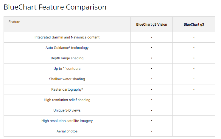
- Industry-Leading Coverage: Updated coastal charts with integrated Garmin and Navionics content for unparalleled detail.
- Auto Guidance Technology: Effortlessly calculates safe routes based on your desired depth and overhead clearance.
- Depth Range Shading: Visualizes up to 10 depth ranges at a glance for quick identification of target depths.
- Accurate Contours: Features 1-foot contour lines to enhance fishing experiences by accurately representing bottom structures.
- Shallow Water Shading: User-defined depth shading indicates shallow waters to help avoid hazards.
- Advanced Visualization: High-resolution relief shading for easy interpretation of underwater profiles.
Data Insights
This charting solution provides extensive coverage of Ireland’s coastlines, from Cork to Belfast, and includes vital inland waterways such as the entire Shannon Inland and Shannon-Erne Waterways. With a combination of Garmin's rich data and Navionics' innovative features, users can expect improved route planning and navigation accuracy, enhancing both safety and enjoyment on the water.
Usage Instructions
To ensure optimal use of the Garmin BlueChart g3 Vision, insert the microSD/SD card into your compatible Garmin device. Utilize the Auto Guidance feature to plan your trip efficiently, and refer to the depth range shading to avoid shallow areas. Regularly update your charts to benefit from the latest data and enhancements.
Design & Material
The Garmin BlueChart g3 Vision boasts a user-friendly design that prioritizes clarity and accessibility. Its intuitive interface allows sailors and boaters to navigate with ease, while the high-resolution imagery enhances situational awareness.
- High-Resolution Satellite Imagery: Realistic visuals overlaid with navigational charts for better clarity.
- FishEye View: Offers a 3D underwater perspective tailored to sonar data for customized viewing.
- MarinerEye View: A comprehensive 3D representation of both above and below the waterline.
- Aerial Photography: Crystal-clear images of ports, harbors, and marinas for better navigation in unfamiliar waters.
- Seamless Integration: Works effortlessly with various Garmin devices for a cohesive user experience.
- Durable Design: Built to withstand marine environments, ensuring long-lasting performance.
Final Verdict
Elevate your maritime adventures with the Garmin Ireland, West Coastal and Inland Charts BlueChart g3 Vision. With its comprehensive features and reliable data, this charting solution is an essential tool for anyone looking to navigate Ireland's waters with confidence and precision. Don't miss out on the opportunity to enhance your boating experience—order yours today!


