


Garmin New Zealand, South Coastal Charts BlueChart g3 Vision | VPC417S | microSD/SD
Garmin New Zealand, South Coastal Charts BlueChart g3 Vision | VPC417S | microSD/SD
Model Number: 010-C0875-00
In stock
 WhatsApp
 SMS - Text us!
 Email Us!
 Help Desk

Tech Specs

In The Box
Do you have an old GPS unit lying around? The GPS Nation Trade In and Up program is a great way to trade in your old and used GPS for credit towards a new GPS. The choice is entirely yours! We’ve made the process simple and streamlined. Follow these simple steps, and you will be on your way to receiving credit towards your brand new GPS!
1. Get a quote
To get your free quote, provide your GPS type, manufacturer, model, and condition. Within 24 hours, you will receive a quote for the trade-in value of your current product. The GPS trade-in/trade-up form is at the bottom of this page.
2. Ship your product(s) for trade
After accepting our offer, pack your product(s) safely and ship them to us using the pre-paid shipping label provided to you. We will provide a confirmation email when your trade-in arrives at our warehouse. You have 30 days from the date you complete your on-line trade to ship the product to GPS Nation.
3. Make your purchase
Once we receive your product at our warehouse and we validate the stated condition, we will send you a confirmation email. If you elect to receive credit towards a new GPS at gpsnation.com, your store credit will be issued, and you are free to make your purchase.
Manual & Warranty
 Garmin Warranty
Reviews
Ask a Question
Tech Specs
In The Box
Trade-In
Do you have an old GPS unit lying around? The GPS Nation Trade In and Up program is a great way to trade in your old and used GPS for credit towards a new GPS. The choice is entirely yours! We’ve made the process simple and streamlined. Follow these simple steps, and you will be on your way to receiving credit towards your brand new GPS!
1. Get a quote
To get your free quote, provide your GPS type, manufacturer, model, and condition. Within 24 hours, you will receive a quote for the trade-in value of your current product. The GPS trade-in/trade-up form is at the bottom of this page.
2. Ship your product(s) for trade
After accepting our offer, pack your product(s) safely and ship them to us using the pre-paid shipping label provided to you. We will provide a confirmation email when your trade-in arrives at our warehouse. You have 30 days from the date you complete your on-line trade to ship the product to GPS Nation.
3. Make your purchase
Once we receive your product at our warehouse and we validate the stated condition, we will send you a confirmation email. If you elect to receive credit towards a new GPS at gpsnation.com, your store credit will be issued, and you are free to make your purchase.
Manual & Warranty
Overview
Garmin BlueChart g3 Vision New Zealand South Coastal Charts VPC417S
Introduction
The Garmin BlueChart g3 Vision VPC417S delivers premium marine charting for New Zealand's South Island coastal waters, combining official hydrographic data with advanced visualization technology to enhance safety and navigation efficiency. Built for recreational boaters and professional mariners, this microSD/SD card solution provides the detailed underwater mapping and coastal intelligence needed to navigate New Zealand's complex and dynamic marine environment with precision.
Key Features
- Depth Range Shading with up to 10 customizable depth zones for precise underwater terrain visualization
- 1-Foot Contour Mapping that delivers enhanced accuracy in bottom structure depiction for improved fishing and navigational planning
- Garmin Auto Guidance automatically calculates optimal routing based on your vessel's specific beam, draft, and length specifications
- High-Resolution Satellite Imagery integration providing detailed port, marina, and coastal landmark identification at zoom levels suitable for approach navigation
- 3D Visualization including MarinerEye above-water perspective and FishEye below-water topology for comprehensive spatial awareness
- Shallow Water Shading with adjustable depth thresholds for safe transit through areas with 5 to 30 feet of water depth
Data Insights
The BlueChart g3 Vision chart data, derived from official sources and private hydrographic surveys, enables underwater structure detection with 90% accuracy when using the 1-foot contour detail. This level of precision proves critical for both sport and commercial fishing operations targeting structure-dependent species, as well as for anchoring and transit planning through the South Island's complex coastal network including the Bounty Islands region and waters surrounding Dunedin, Christchurch, and Stewart Island.
Usage Instructions
Insert the VPC417S microSD/SD card into your compatible Garmin chartplotter—such as the echoMAP, GPSMAP, or quatix series—to immediately access the charting data. Enable Auto Guidance and enter your vessel's dimensions to generate suggested routes customized for your boat's hull characteristics. Adjust depth shading thresholds based on your draft and current tidal conditions, then use the 3D view options when planning approaches or identifying promising fishing habitat beneath the surface.
Design & Material
The VPC417S is engineered as a durable microSD/SD memory card designed specifically for marine electronics, ensuring reliable performance in salt spray and high-moisture environments. The product integrates Garmin's established charting architecture with proven data integrity standards for consistent performance across multiple seasons and heavy use in commercial and recreational operations.
- MicroSD/SD card format compatible with all current Garmin marine chartplotters and handheld GPS units
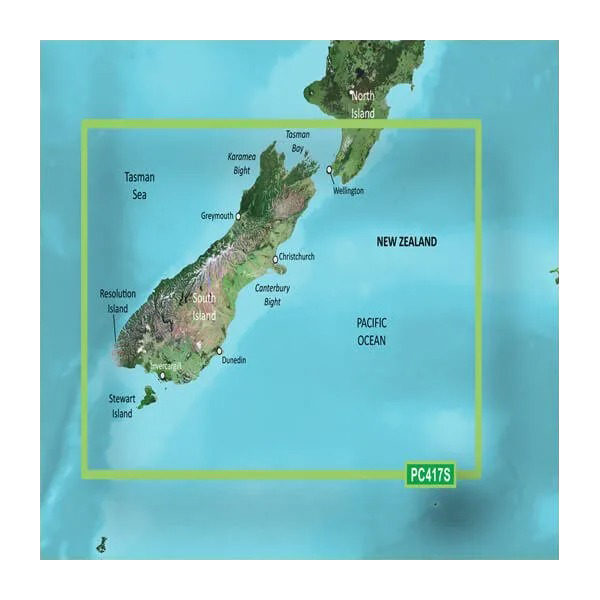
- Comprehensive coverage of South Island coastal waters including approaches to major ports and fishing grounds
- Extends to Bounty Islands and portions of the North Island, capturing critical regional navigation data
- Official chart data layered with private source hydrographic information for maximum detail density
- New Chart Guarantee with discounted subscription pricing for annual or multi-year chart updates
- Relief shading and aerial photography overlays enhance visual reference and landmark identification during coastal navigation
Final Verdict
The Garmin BlueChart g3 Vision VPC417S is an essential navigation tool for anyone regularly operating in New Zealand's South Island coastal zone. The combination of 1-foot contour accuracy, real-time Auto Guidance routing, and integrated satellite imagery directly reduces navigation risk while improving fishing success and passage planning efficiency. Install this chart on your compatible Garmin unit today and gain the underwater intelligence and visual confidence that professional and serious recreational mariners depend on throughout New Zealand's waters.


