


Garmin Norway, Vestfjd to Svalbard and Varanger Charts BlueChart g3 Vision | VEU054R | microSD/SD
Garmin Norway, Vestfjd to Svalbard and Varanger Charts BlueChart g3 Vision | VEU054R | microSD/SD
Model Number: 010-C0790-00
In stock
 WhatsApp
 SMS - Text us!
 Email Us!
 Help Desk

Tech Specs
In The Box
Do you have an old GPS unit lying around? The GPS Nation Trade In and Up program is a great way to trade in your old and used GPS for credit towards a new GPS. The choice is entirely yours! We’ve made the process simple and streamlined. Follow these simple steps, and you will be on your way to receiving credit towards your brand new GPS!
1. Get a quote
To get your free quote, provide your GPS type, manufacturer, model, and condition. Within 24 hours, you will receive a quote for the trade-in value of your current product. The GPS trade-in/trade-up form is at the bottom of this page.
2. Ship your product(s) for trade
After accepting our offer, pack your product(s) safely and ship them to us using the pre-paid shipping label provided to you. We will provide a confirmation email when your trade-in arrives at our warehouse. You have 30 days from the date you complete your on-line trade to ship the product to GPS Nation.
3. Make your purchase
Once we receive your product at our warehouse and we validate the stated condition, we will send you a confirmation email. If you elect to receive credit towards a new GPS at gpsnation.com, your store credit will be issued, and you are free to make your purchase.
Manual & Warranty
 Garmin Warranty
Reviews
Ask a Question
Tech Specs
In The Box
Trade-In
Do you have an old GPS unit lying around? The GPS Nation Trade In and Up program is a great way to trade in your old and used GPS for credit towards a new GPS. The choice is entirely yours! We’ve made the process simple and streamlined. Follow these simple steps, and you will be on your way to receiving credit towards your brand new GPS!
1. Get a quote
To get your free quote, provide your GPS type, manufacturer, model, and condition. Within 24 hours, you will receive a quote for the trade-in value of your current product. The GPS trade-in/trade-up form is at the bottom of this page.
2. Ship your product(s) for trade
After accepting our offer, pack your product(s) safely and ship them to us using the pre-paid shipping label provided to you. We will provide a confirmation email when your trade-in arrives at our warehouse. You have 30 days from the date you complete your on-line trade to ship the product to GPS Nation.
3. Make your purchase
Once we receive your product at our warehouse and we validate the stated condition, we will send you a confirmation email. If you elect to receive credit towards a new GPS at gpsnation.com, your store credit will be issued, and you are free to make your purchase.
Manual & Warranty
Overview
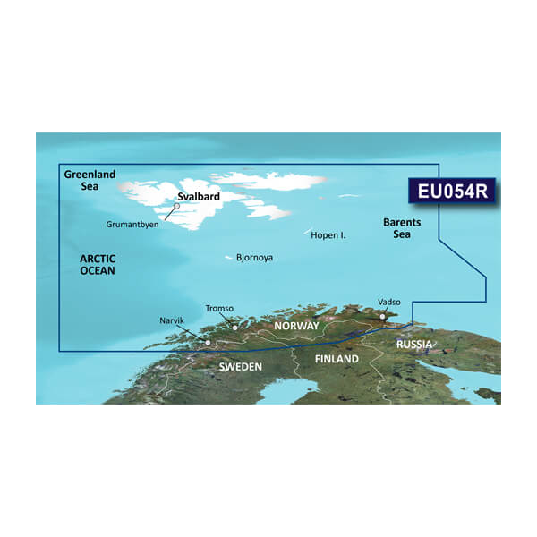
Garmin Norway Vestfjorden to Svalbard and Varanger BlueChart g3 Vision Charts
Introduction
The Garmin BlueChart g3 Vision VEU054R chart card delivers precise marine navigation for Norway's northern coastlines, from Vestfjorden through the Svalbard archipelago to the Varanger Peninsula. Engineered for both commercial fishing operations and recreational boaters, this microSD/SD chart combines Garmin's bathymetric expertise with Navionics data integration to provide the clarity and detail needed for safe passage through challenging Arctic and sub-Arctic waters. Whether you're navigating between islands, locating productive fishing grounds, or planning coastal transits, this charting solution reduces guesswork and increases confidence in remote Norwegian waters.
Key Features
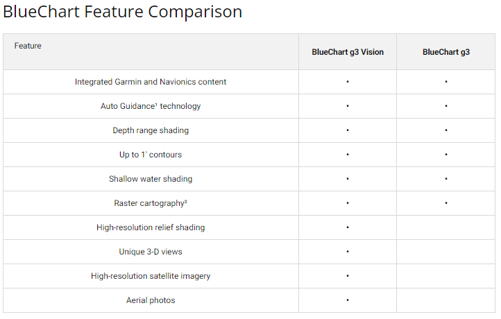
- Merged Garmin and Navionics data for 30% increased coastal coverage compared to earlier chart versions
- 1-foot contour lines enabling precise identification of underwater structure and depth changes critical for fishing and grounding avoidance
- Depth Range Shading with up to 10 configurable ranges for quick visual depth assessment at any zoom level
- Auto Guidance technology that calculates optimal routes based on your vessel's draft and required clearance specifications
- User-defined shallow water shading to highlight custom depth thresholds matching your boat's hull characteristics
- High-resolution satellite imagery overlay that displays realistic coastal landmarks and reference features alongside vector chart data
Data Insights
The BlueChart g3 Vision platform represents a significant cartographic advancement, delivering 30% more coastal area detail than preceding chart generations. This expanded coverage substantially reduces navigation blind spots and increases positioning confidence in waters where traditional paper charts or older digital datasets may lack critical bathymetric and obstruction data. Mariners operating in Svalbard and the Varanger region benefit from improved contouring accuracy and reduced reliance on local knowledge alone, particularly valuable during seasonal weather transitions or unfamiliar passages.
Usage Instructions
Insert the microSD/SD card into any compatible Garmin chartplotter, fish finder, or marine navigation device. Launch the chart application and activate Auto Guidance to quickly generate depth-aware routes for your intended destination. Update chart data periodically through Garmin Express software to access the latest corrections, seasonal hazard warnings, and bathymetric refinements. Customize your depth shading preferences and contour display density to match your specific fishing strategy or navigation requirements.
Design & Material
The VEU054R chart is formatted as a microSD/SD card, a format chosen for compatibility with Garmin's broadest device ecosystem and for durability in marine environments. The compact form factor minimizes storage space while maximizing accessibility, allowing rapid chart updates or device transfers without extensive reconfiguration.
- MicroSD/SD card format compatible with Garmin plotters, chartplotters, and handheld devices without external readers
- Engineered for salt-spray, moisture, and temperature fluctuations characteristic of northern Atlantic and Arctic maritime conditions
- Preloaded and ready for immediate use without requiring additional software installation or online activation
- Intuitive menu structure integrated into Garmin's standard interface, minimizing learning curve for existing Garmin device users
- Compact storage profile fits standard device card slots without bulky adapters or external housing
- Vector-based chart architecture allows smooth zooming and panning without quality degradation at varying scales
Final Verdict
For skippers and anglers operating along Norway's northern coast, the Garmin BlueChart g3 Vision VEU054R represents the most current and detailed charting option available for Vestfjorden through Svalbard and Varanger waters. The combination of 1-foot contours, Auto Guidance routing, and satellite imagery overlay delivers navigation precision that directly translates to safer passages, better fishing success, and reduced operational uncertainty in remote areas. If your maritime activities depend on accurate bathymetry and reliable coastal detail, this chart card is an essential upgrade for your Garmin navigation system.


