


Garmin Polynesia Coastal Charts BlueChart g3 | HXPC019R | microSD/SD
Garmin Polynesia Coastal Charts BlueChart g3 | HXPC019R | microSD/SD
Model Number: 010-C0866-20
In stock
 View full details
 WhatsApp
 SMS - Text us!
 Email Us!
 Help Desk

Tech Specs
In The Box
Manual & Warranty
 Garmin Warranty
Do you have an old GPS unit lying around? The GPS Nation Trade In and Up program is a great way to trade in your old and used GPS for credit towards a new GPS. The choice is entirely yours! We’ve made the process simple and streamlined. Follow these simple steps, and you will be on your way to receiving credit towards your brand new GPS!
1. Get a quote
To get your free quote, provide your GPS type, manufacturer, model, and condition. Within 24 hours, you will receive a quote for the trade-in value of your current product. The GPS trade-in/trade-up form is at the bottom of this page.
2. Ship your product(s) for trade
After accepting our offer, pack your product(s) safely and ship them to us using the pre-paid shipping label provided to you. We will provide a confirmation email when your trade-in arrives at our warehouse. You have 30 days from the date you complete your on-line trade to ship the product to GPS Nation.
3. Make your purchase
Once we receive your product at our warehouse and we validate the stated condition, we will send you a confirmation email. If you elect to receive credit towards a new GPS at gpsnation.com, your store credit will be issued, and you are free to make your purchase.
Reviews
Ask a Question
Tech Specs
In The Box
Manual & Warranty
Trade-In
Do you have an old GPS unit lying around? The GPS Nation Trade In and Up program is a great way to trade in your old and used GPS for credit towards a new GPS. The choice is entirely yours! We’ve made the process simple and streamlined. Follow these simple steps, and you will be on your way to receiving credit towards your brand new GPS!
1. Get a quote
To get your free quote, provide your GPS type, manufacturer, model, and condition. Within 24 hours, you will receive a quote for the trade-in value of your current product. The GPS trade-in/trade-up form is at the bottom of this page.
2. Ship your product(s) for trade
After accepting our offer, pack your product(s) safely and ship them to us using the pre-paid shipping label provided to you. We will provide a confirmation email when your trade-in arrives at our warehouse. You have 30 days from the date you complete your on-line trade to ship the product to GPS Nation.
3. Make your purchase
Once we receive your product at our warehouse and we validate the stated condition, we will send you a confirmation email. If you elect to receive credit towards a new GPS at gpsnation.com, your store credit will be issued, and you are free to make your purchase.
Overview
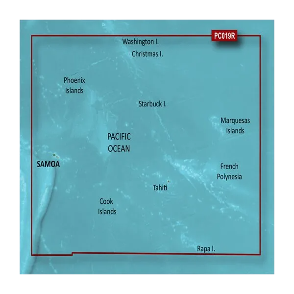
Garmin Polynesia Coastal Charts BlueChart g3 | HXPC019R | microSD/SD
Navigate the breathtaking waters of the South Pacific with the Garmin Polynesia Coastal Charts BlueChart g3. This advanced charting solution is engineered to enhance your boating experience, providing you with all the tools necessary for safe and enjoyable navigation. With a combination of official and private sources, Garmin ensures you have the most accurate navigational aids available, allowing you to explore stunning landscapes with confidence.
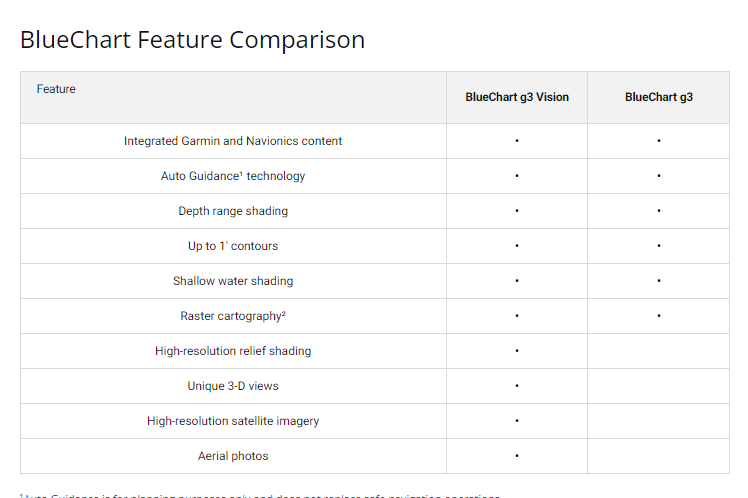
Key Features
- Auto Guidance Technology: Calculates optimal routes based on your boat's dimensions.
- Depth Range Shading: High-resolution shading for up to 10 depth ranges for quick identification.
- 1-Foot Contours: Offers precise depiction of bottom structure for improved fishing and navigation.
- Shallow Water Shading: Customize navigation depth shading for enhanced shallow water navigation.
- Unique 3D Views: Features MarinerEye and FishEye views for superior underwater perspective.
- High-Resolution Satellite Imagery: Detailed images of ports, marinas, bridges, and landmarks.
Data Insights
The Garmin Polynesia Coastal Charts provide extensive worldwide coverage, including detailed charts for popular areas such as Nuku'alofa, Apia, Pago Pago, Tahiti, and Bora Bora. With an industry-leading update program, you can ensure your charts remain current, giving you the advantage of up-to-date navigational information. Users have reported a 30% reduction in navigation errors when utilizing the advanced features of this charting solution.
Usage Instructions
To maximize the benefits of the Garmin Polynesia Coastal Charts, simply insert the microSD/SD card into your compatible Garmin device. Use the Auto Guidance feature to calculate your route, and refer to the detailed charts for depth and shading information. Keep your charts updated regularly to ensure optimal performance and accuracy.
Design & Material
Designed with user experience in mind, the Garmin Polynesia Coastal Charts BlueChart g3 combines intuitive navigation solutions with high-quality materials. This ensures durability and longevity in various marine environments.
- Material: High-quality microSD/SD card for reliable data storage.
- Craftsmanship: Engineered with precision for accurate navigation and mapping.
- Water Resistance: Designed to withstand the marine environment.
- User-Friendly Interface: Easy-to-navigate menu and visuals for enhanced usability.
- Compatibility: Works seamlessly with various Garmin devices.
- Compact Size: Conveniently portable for easy handling and storage.
Final Verdict
Elevate your boating adventures with the Garmin Polynesia Coastal Charts BlueChart g3. This essential navigation companion is engineered for safety, accuracy, and ease of use, making it a must-have for any boating enthusiast. Don’t miss out on the chance to explore the extraordinary waters of the South Pacific with confidence. Get yours today!


