


Garmin South America, West Coast Charts BlueChart g3 | HXSA002R | microSD/SD
Garmin South America, West Coast Charts BlueChart g3 | HXSA002R | microSD/SD
Model Number: 010-C1063-20
In stock
 View full details
 WhatsApp
 SMS - Text us!
 Email Us!
 Help Desk

Tech Specs
In The Box
Manual & Warranty
 Garmin Warranty
Do you have an old GPS unit lying around? The GPS Nation Trade In and Up program is a great way to trade in your old and used GPS for credit towards a new GPS. The choice is entirely yours! We’ve made the process simple and streamlined. Follow these simple steps, and you will be on your way to receiving credit towards your brand new GPS!
1. Get a quote
To get your free quote, provide your GPS type, manufacturer, model, and condition. Within 24 hours, you will receive a quote for the trade-in value of your current product. The GPS trade-in/trade-up form is at the bottom of this page.
2. Ship your product(s) for trade
After accepting our offer, pack your product(s) safely and ship them to us using the pre-paid shipping label provided to you. We will provide a confirmation email when your trade-in arrives at our warehouse. You have 30 days from the date you complete your on-line trade to ship the product to GPS Nation.
3. Make your purchase
Once we receive your product at our warehouse and we validate the stated condition, we will send you a confirmation email. If you elect to receive credit towards a new GPS at gpsnation.com, your store credit will be issued, and you are free to make your purchase.
Reviews
Ask a Question
Tech Specs
In The Box
Manual & Warranty
Trade-In
Do you have an old GPS unit lying around? The GPS Nation Trade In and Up program is a great way to trade in your old and used GPS for credit towards a new GPS. The choice is entirely yours! We’ve made the process simple and streamlined. Follow these simple steps, and you will be on your way to receiving credit towards your brand new GPS!
1. Get a quote
To get your free quote, provide your GPS type, manufacturer, model, and condition. Within 24 hours, you will receive a quote for the trade-in value of your current product. The GPS trade-in/trade-up form is at the bottom of this page.
2. Ship your product(s) for trade
After accepting our offer, pack your product(s) safely and ship them to us using the pre-paid shipping label provided to you. We will provide a confirmation email when your trade-in arrives at our warehouse. You have 30 days from the date you complete your on-line trade to ship the product to GPS Nation.
3. Make your purchase
Once we receive your product at our warehouse and we validate the stated condition, we will send you a confirmation email. If you elect to receive credit towards a new GPS at gpsnation.com, your store credit will be issued, and you are free to make your purchase.
Overview
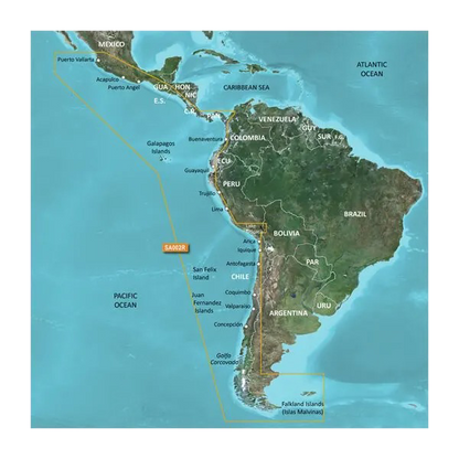
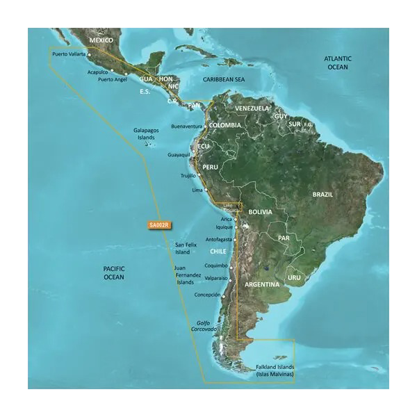
Garmin South America, West Coast Charts BlueChart g3 | HXSA002R | microSD/SD
Explore the stunning waters of Central and South America with the Garmin South America, West Coast Charts BlueChart g3. This premium navigation tool is designed to provide you with unparalleled performance benefits, ensuring a safe and efficient journey through some of the most beautiful and intricate coastal waters in the world. Whether you're an experienced mariner or a novice, this chart package equips you with crucial insights for a successful maritime adventure.
Key Features
- Comprehensive Coverage: Navigate from Acapulco, Mexico, to Tierra del Fuego and up to Puerto Deseado, Argentina, including the east coast of Panama and the Galapagos Islands.
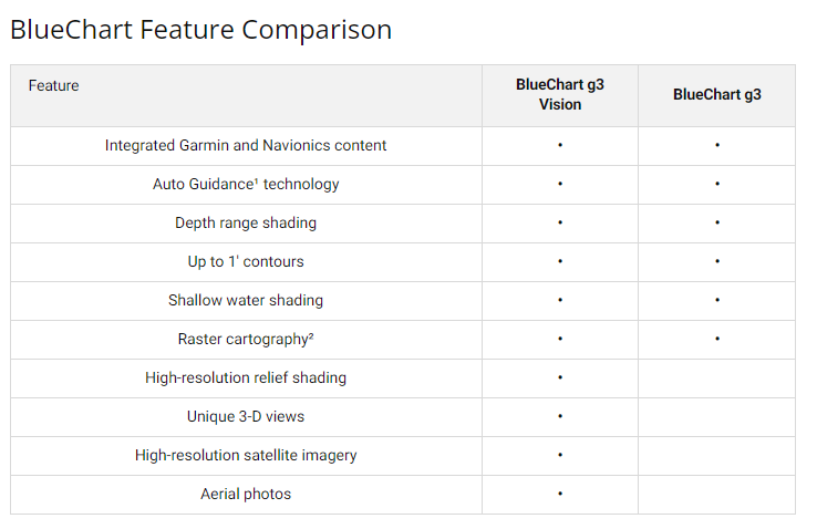
- Auto Guidance Technology: Calculates suggested routes based on your boat’s dimensions for safe navigation.
- Depth Range Shading: High-resolution shading for 10 depth ranges helps you quickly identify target depths.
- Detailed Contours: Up to 1-foot contours provide precise bottom structure details, enhancing your fishing experience.
- Shallow Water Shading: User-defined depth shading ensures safe navigation in shallow waters.
- Unique 3D Views: MarinerEye and FishEye views offer 3D representations of underwater terrain.
- High-Resolution Satellite Imagery: Overlay navigational charts with high-res satellite images for improved situational awareness.
- Aerial Photography: Crystal-clear images of ports, harbors, and marinas help familiarize you with new areas.
Data Insights
The Garmin South America, West Coast Charts BlueChart g3 is built on rigorous data collection from official charts and private sources, ensuring accuracy for your voyages. Enjoy up to 97% coverage of the specified regions, enabling you to navigate with confidence. With detailed underwater mapping, you're equipped to make informed decisions, drastically reducing the risk of grounding or misnavigation.
Usage Instructions
To make the most of your BlueChart g3, simply insert the microSD/SD card into your compatible Garmin device. Follow the on-screen prompts to download and activate the charts. For optimal performance, ensure that your device's software is updated regularly to access the latest features and chart updates.
Design & Material
The Garmin South America, West Coast Charts BlueChart g3 is designed for durability and ease of use. Its robust construction ensures longevity, while the user-friendly interface makes navigation a breeze.
- Durable microSD/SD Card: Built to withstand marine environments.
- Easy Installation: Plug-and-play functionality for quick access to charts.
- High-Quality Graphics: Crisp, clear images enhance usability.
- Compact Size: Easily portable, fitting seamlessly into your navigation setup.
- Comprehensive Updates: Regular updates ensure you have the latest navigational data.
- Environmentally Resistant: Designed to endure harsh marine conditions.
Final Verdict
Enhance your maritime adventures with the Garmin South America, West Coast Charts BlueChart g3. This essential navigational tool combines comprehensive data with cutting-edge technology, ensuring a safe and enjoyable voyage. Don't miss out on the opportunity to experience these breathtaking waters with confidence. Equip yourself with the BlueChart g3 today!


