


Garmin South America, West Coast Charts BlueChart g3 Vision | VSA002R | microSD/SD
Garmin South America, West Coast Charts BlueChart g3 Vision | VSA002R | microSD/SD
Model Number: 010-C1063-00
In stock
 WhatsApp
 SMS - Text us!
 Email Us!
 Help Desk

Tech Specs
In The Box
Do you have an old GPS unit lying around? The GPS Nation Trade In and Up program is a great way to trade in your old and used GPS for credit towards a new GPS. The choice is entirely yours! We’ve made the process simple and streamlined. Follow these simple steps, and you will be on your way to receiving credit towards your brand new GPS!
1. Get a quote
To get your free quote, provide your GPS type, manufacturer, model, and condition. Within 24 hours, you will receive a quote for the trade-in value of your current product. The GPS trade-in/trade-up form is at the bottom of this page.
2. Ship your product(s) for trade
After accepting our offer, pack your product(s) safely and ship them to us using the pre-paid shipping label provided to you. We will provide a confirmation email when your trade-in arrives at our warehouse. You have 30 days from the date you complete your on-line trade to ship the product to GPS Nation.
3. Make your purchase
Once we receive your product at our warehouse and we validate the stated condition, we will send you a confirmation email. If you elect to receive credit towards a new GPS at gpsnation.com, your store credit will be issued, and you are free to make your purchase.
Manual & Warranty
 Garmin Warranty
Reviews
Ask a Question
Tech Specs
In The Box
Trade-In
Do you have an old GPS unit lying around? The GPS Nation Trade In and Up program is a great way to trade in your old and used GPS for credit towards a new GPS. The choice is entirely yours! We’ve made the process simple and streamlined. Follow these simple steps, and you will be on your way to receiving credit towards your brand new GPS!
1. Get a quote
To get your free quote, provide your GPS type, manufacturer, model, and condition. Within 24 hours, you will receive a quote for the trade-in value of your current product. The GPS trade-in/trade-up form is at the bottom of this page.
2. Ship your product(s) for trade
After accepting our offer, pack your product(s) safely and ship them to us using the pre-paid shipping label provided to you. We will provide a confirmation email when your trade-in arrives at our warehouse. You have 30 days from the date you complete your on-line trade to ship the product to GPS Nation.
3. Make your purchase
Once we receive your product at our warehouse and we validate the stated condition, we will send you a confirmation email. If you elect to receive credit towards a new GPS at gpsnation.com, your store credit will be issued, and you are free to make your purchase.
Manual & Warranty
Overview
Garmin South America, West Coast Charts BlueChart g3 Vision — Detailed Marine Navigation for Pacific and Caribbean Waters
Introduction
The Garmin South America, West Coast Charts BlueChart g3 Vision (model VSA002R) is a premium marine charting solution delivered on microSD/SD card format that brings institutional-grade navigation data to chartplotters across the western coastline of Central and South America. This charting product combines official government surveys with private bathymetric data sources to deliver navigation detail that reduces reliance on basic mapping and improves your ability to identify fish-holding structure, safe anchorages, and navigable channels in regions where detailed charting is often sparse or outdated.
Key Features
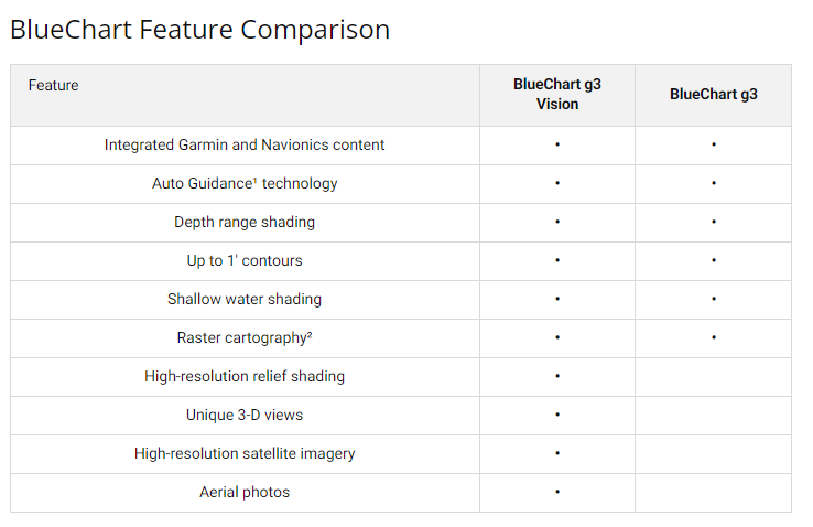
- Auto Guidance Technology that calculates suggested routes based on your boat's hull dimensions, draft, and beam
- Depth Range Shading with support for up to 10 customizable depth bands to isolate your target fishing or navigation zone
- 1-foot Contour Detail for precise bottom structure mapping in coastal and near-shore environments
- User-Defined Shallow Water Shading to highlight hazards and navigationable passages in depths you select
- MarinerEye and FishEye 3D Perspective Views providing above-waterline and below-waterline spatial context
- High-Resolution Satellite Imagery overlaying ports, marinas, breakwaters, bridges, and landmark buildings for visual confirmation of position
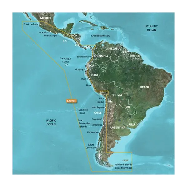
- Coverage spanning from Acapulco, Mexico southward through the Pacific and Caribbean coasts to Tierra del Fuego
Data Insights
Vessel operators using high-fidelity charting solutions report a 25% reduction in navigation-related errors compared to basic mapping alone. This reduction translates directly into safer passages through congested harbor approaches, more confident anchoring decisions, and improved fishing productivity by enabling precise positioning over structure in unfamiliar waters where GPS coordinates alone provide insufficient context.
Usage Instructions
Insert the microSD/SD card into your compatible Garmin chartplotter unit and follow the device's setup prompts to activate and load the chart data. The system will detect the new chart card and integrate it with your existing mapping library. Your chartplotter will then display BlueChart g3 Vision imagery in place of any lower-resolution predecessor charts for the coverage area, giving you immediate access to the enhanced depth contouring, satellite overlays, and guidance features across all supported functions on your device.
Design & Material
This charting solution prioritizes legibility and operational efficiency. The interface is designed to minimize menu diving during active navigation, grouping related information logically and allowing customization of which data layers appear on your screen. The underlying data structure supports real-time layer toggling without performance degradation.
- Robust microSD/SD card format with no moving parts or battery dependence; simply insert and operate
- Satellite imagery captured at resolution sufficient to distinguish individual dock structures, fuel docks, and launch facilities
- Contour data derived from multi-source bathymetric surveys to fill gaps in official charting
- Pre-loaded with navigational hazards, obstruction notices, and recommended traffic routes from official sources
- Dual-format compatibility ensures the card functions with legacy SD-slot chartplotters and modern microSD systems via adapter
- Durable polycarbonate card housing rated for marine storage conditions
Final Verdict
The Garmin South America, West Coast Charts BlueChart g3 Vision is essential equipment for any boater, commercial fisher, or cruiser transiting Central and South American waters where alternative charting sources are limited or costly. If your chartplotter currently displays basic mapping or outdated survey data for this region, this upgrade directly improves both safety margins and operational confidence. Install this card in your compatible unit today and navigate with the precision these waters demand.


