


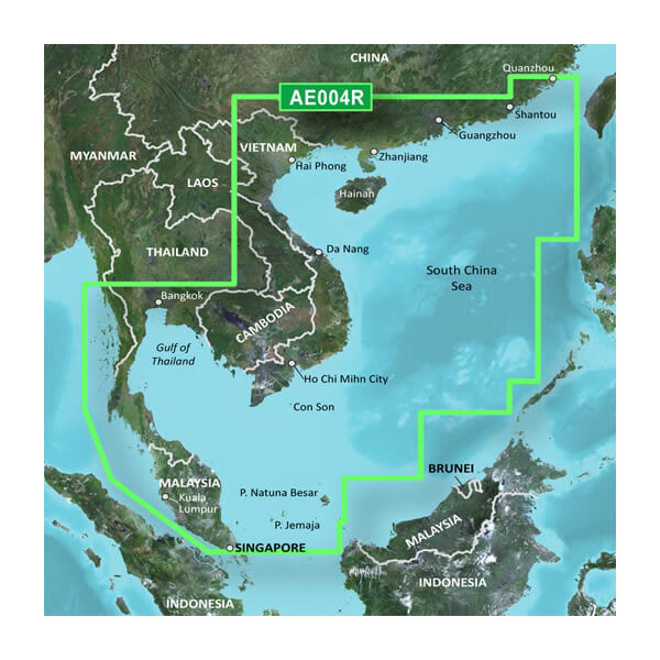
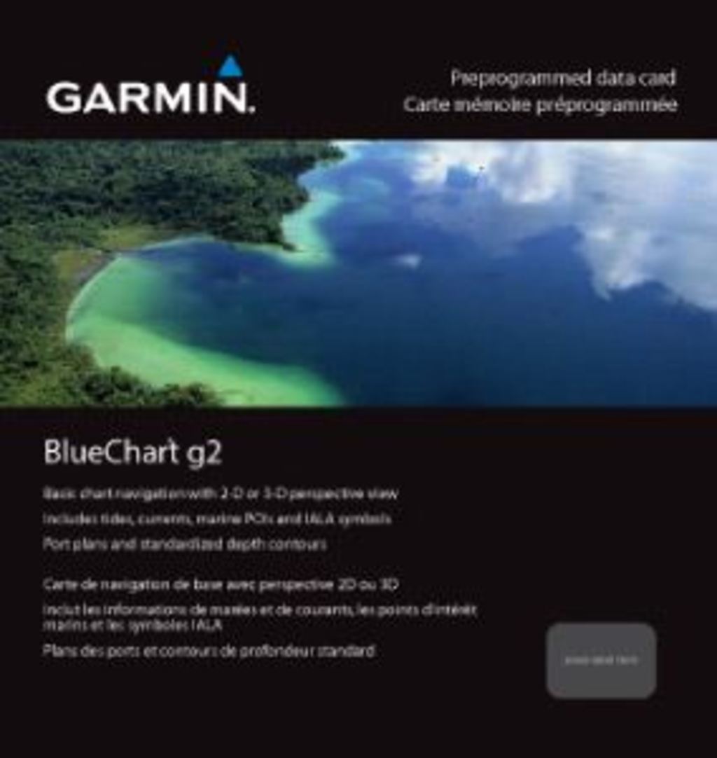
Garmin South China Sea Coastal Charts BlueChart g3 | HXAE004R | microSD/SD
Garmin South China Sea Coastal Charts BlueChart g3 | HXAE004R | microSD/SD
Model Number: 010-C0879-20
In stock
 View full details
 WhatsApp
 SMS - Text us!
 Email Us!
 Help Desk

Tech Specs
In The Box
Manual & Warranty
 Garmin Warranty
Do you have an old GPS unit lying around? The GPS Nation Trade In and Up program is a great way to trade in your old and used GPS for credit towards a new GPS. The choice is entirely yours! We’ve made the process simple and streamlined. Follow these simple steps, and you will be on your way to receiving credit towards your brand new GPS!
1. Get a quote
To get your free quote, provide your GPS type, manufacturer, model, and condition. Within 24 hours, you will receive a quote for the trade-in value of your current product. The GPS trade-in/trade-up form is at the bottom of this page.
2. Ship your product(s) for trade
After accepting our offer, pack your product(s) safely and ship them to us using the pre-paid shipping label provided to you. We will provide a confirmation email when your trade-in arrives at our warehouse. You have 30 days from the date you complete your on-line trade to ship the product to GPS Nation.
3. Make your purchase
Once we receive your product at our warehouse and we validate the stated condition, we will send you a confirmation email. If you elect to receive credit towards a new GPS at gpsnation.com, your store credit will be issued, and you are free to make your purchase.
Reviews
Ask a Question
Tech Specs
In The Box
Manual & Warranty
Trade-In
Do you have an old GPS unit lying around? The GPS Nation Trade In and Up program is a great way to trade in your old and used GPS for credit towards a new GPS. The choice is entirely yours! We’ve made the process simple and streamlined. Follow these simple steps, and you will be on your way to receiving credit towards your brand new GPS!
1. Get a quote
To get your free quote, provide your GPS type, manufacturer, model, and condition. Within 24 hours, you will receive a quote for the trade-in value of your current product. The GPS trade-in/trade-up form is at the bottom of this page.
2. Ship your product(s) for trade
After accepting our offer, pack your product(s) safely and ship them to us using the pre-paid shipping label provided to you. We will provide a confirmation email when your trade-in arrives at our warehouse. You have 30 days from the date you complete your on-line trade to ship the product to GPS Nation.
3. Make your purchase
Once we receive your product at our warehouse and we validate the stated condition, we will send you a confirmation email. If you elect to receive credit towards a new GPS at gpsnation.com, your store credit will be issued, and you are free to make your purchase.
Overview
Garmin South China Sea Coastal Charts BlueChart g3 | HXAE004R | microSD/SD
Navigate the stunning and intricate waters of the South China Sea with utmost confidence using the Garmin South China Sea Coastal Charts BlueChart g3. This cutting-edge chart is meticulously designed for mariners who prioritize accuracy and detail in their navigation, ensuring a safer and more informed journey through these vibrant waters.
Key Features
- Comprehensive Coverage: General coverage of the coasts of the Malay Peninsula, Thailand, Cambodia, Vietnam, and China, extending to Quanzhou, including Hainan Island.
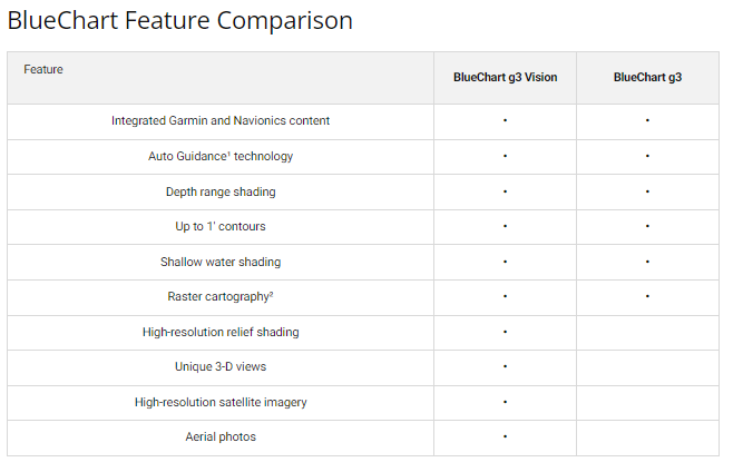
- Advanced Chart Detail: Derived from both official charts and private sources, featuring essential navigational aids such as spot soundings, depth contours, and details on harbors and marinas.
- Depth Range Shading: High-resolution depth range shading covering up to 10 depth ranges for quick identification of target depths.
- 1-Foot Contours: Enhanced navigation experience with 1-foot contours, ideal for fishing and navigating in swamps, canals, and marinas.
- Shallow Water Shading: User-defined shallow water shading feature to set depth shading levels for challenging water conditions.
- New Chart Guarantee: Keep your charts updated with our industry-leading New Chart Guarantee and discount card update program.
Data Insights
With a remarkable accuracy rate, the Garmin South China Sea Coastal Charts BlueChart g3 offers mariners enhanced navigation capabilities. Boasting a coverage area of over 1,000 nautical miles along the coastlines, these charts significantly reduce the risk of navigational errors, helping to ensure a safer maritime experience. The detailed bathymetry allows for precision navigation in variable underwater conditions.
Usage Instructions
For optimal performance, simply insert the microSD/SD card into your compatible Garmin device. Ensure your device is updated with the latest software to take full advantage of all features. Familiarize yourself with the chart details and utilize the customizable settings for depth shading tailored to your specific navigation needs.
Design & Material
The Garmin South China Sea Coastal Charts BlueChart g3 features a sleek and compact design, ensuring easy installation and portability. Constructed with high-quality materials to ensure durability, this chart is optimized for marine environments.
- Format: microSD/SD card for easy compatibility with Garmin devices.
- Durability: Built to withstand marine conditions, ensuring longevity and reliability.
- Precision: Advanced data derived from trusted sources for utmost accuracy.
- Portability: Lightweight design allows for easy transport and usage on-the-go.
- User-Friendly: Simple installation process for immediate use.
- Visual Clarity: High-resolution detail with intuitive chart designs for easy reading.
Final Verdict
Investing in the Garmin South China Sea Coastal Charts BlueChart g3 is essential for any mariner navigating these complex waters. With its comprehensive features and advanced technology, you can be assured of a safer and more enjoyable experience on the water. Don't miss out on the opportunity to enhance your navigation capabilities—order your Garmin South China Sea Coastal Charts today!


