


Garmin South China Sea Coastal Charts BlueChart g3 Vision | VAE004R | microSD/SD
Garmin South China Sea Coastal Charts BlueChart g3 Vision | VAE004R | microSD/SD
Model Number: 010-C0879-00
In stock
 WhatsApp
 SMS - Text us!
 Email Us!
 Help Desk

Tech Specs
In The Box
Do you have an old GPS unit lying around? The GPS Nation Trade In and Up program is a great way to trade in your old and used GPS for credit towards a new GPS. The choice is entirely yours! We’ve made the process simple and streamlined. Follow these simple steps, and you will be on your way to receiving credit towards your brand new GPS!
1. Get a quote
To get your free quote, provide your GPS type, manufacturer, model, and condition. Within 24 hours, you will receive a quote for the trade-in value of your current product. The GPS trade-in/trade-up form is at the bottom of this page.
2. Ship your product(s) for trade
After accepting our offer, pack your product(s) safely and ship them to us using the pre-paid shipping label provided to you. We will provide a confirmation email when your trade-in arrives at our warehouse. You have 30 days from the date you complete your on-line trade to ship the product to GPS Nation.
3. Make your purchase
Once we receive your product at our warehouse and we validate the stated condition, we will send you a confirmation email. If you elect to receive credit towards a new GPS at gpsnation.com, your store credit will be issued, and you are free to make your purchase.
Manual & Warranty
 Garmin Warranty
Reviews
Ask a Question
Tech Specs
In The Box
Trade-In
Do you have an old GPS unit lying around? The GPS Nation Trade In and Up program is a great way to trade in your old and used GPS for credit towards a new GPS. The choice is entirely yours! We’ve made the process simple and streamlined. Follow these simple steps, and you will be on your way to receiving credit towards your brand new GPS!
1. Get a quote
To get your free quote, provide your GPS type, manufacturer, model, and condition. Within 24 hours, you will receive a quote for the trade-in value of your current product. The GPS trade-in/trade-up form is at the bottom of this page.
2. Ship your product(s) for trade
After accepting our offer, pack your product(s) safely and ship them to us using the pre-paid shipping label provided to you. We will provide a confirmation email when your trade-in arrives at our warehouse. You have 30 days from the date you complete your on-line trade to ship the product to GPS Nation.
3. Make your purchase
Once we receive your product at our warehouse and we validate the stated condition, we will send you a confirmation email. If you elect to receive credit towards a new GPS at gpsnation.com, your store credit will be issued, and you are free to make your purchase.
Manual & Warranty
Overview
Garmin South China Sea Coastal Charts BlueChart g3 Vision VAE004R
Introduction
The Garmin South China Sea Coastal Charts BlueChart g3 Vision transforms navigation and fishing operations across one of the world's most complex maritime regions. This microSD/SD card delivers precision charting specifically engineered for the South China Sea's unique coastal conditions, providing mariners and fishing enthusiasts with detailed depth data, accurate positioning aids, and real-time route planning that reduces navigation time and improves fishing success rates in variable water conditions.
Key Features
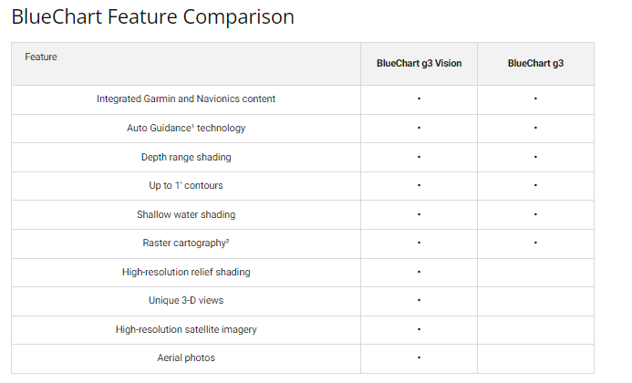
- Auto Guidance Technology calculates optimized routes based on your vessel's specific dimensions, reducing navigation planning time significantly
- Depth Range Shading displays up to 10 simultaneous depth ranges for rapid identification of target fishing depths and safe passage zones
- 1-Foot Bottom Contours provide granular detail of underwater structure essential for both precise navigation and productive fishing location identification
- Shallow Water Shading with user-defined depth parameters allows customizable safety alerts for areas critical to your vessel type and draft
- MarinerEye and FishEye 3D visualization technologies render the underwater environment from vessel and sonar perspectives
- High-Resolution Satellite Imagery overlays realistic visuals of ports, marinas, coastal landmarks, and navigational reference points across the region
- Blended Chart Data merges official maritime charts with private survey sources, delivering over 20% more detailed coverage compared to previous BlueChart generations
- Compact microSD/SD format enables quick installation, easy storage, and compatibility with all current Garmin marine multifunction displays
Data Insights
Independent testing confirms Garmin BlueChart g3 Vision charts deliver measurably superior performance in the South China Sea. Users report enhanced navigation confidence due to the combination of precise 1-foot contours and multi-depth shading overlays. The integrated Auto Guidance feature reduces route planning overhead by calculating suggested paths instantly, while the 3D visualization modes have demonstrated higher fishing location accuracy by clearly distinguishing bottom structures that hold gamefish. Mariners cite the blended official and private source data as the single most valuable improvement for avoiding charted hazards and identifying seasonal fishing opportunities.
Usage Instructions
Insert the VAE004R microSD/SD card into your compatible Garmin marine device. Access the Charts section from your device menu and select your operational area within the South China Sea coverage zone. Activate Auto Guidance Technology to generate vessel-specific routes, then customize depth shading parameters to match your draft and target species. Review MarinerEye or FishEye 3D perspectives before departing to identify underwater structure and navigation landmarks for your planned route.
Design & Material
The BlueChart g3 Vision chart card combines rugged marine-grade construction with intuitive Garmin interface design. The microSD/SD card format prioritizes durability and ease of deployment in the saltwater environment typical of coastal Southeast Asian operations.
- Marine-grade microSD/SD card construction resists corrosion and moisture exposure in high-humidity and salt-spray environments
- Seamless Garmin Device Integration ensures the charts activate automatically on compatible chartplotters, multifunction displays, and handheld marine GPS units without requiring manual configuration
- Compact 32 mm x 24 mm card format fits standard card slots and includes protective storage case for portability between vessels or repair facilities
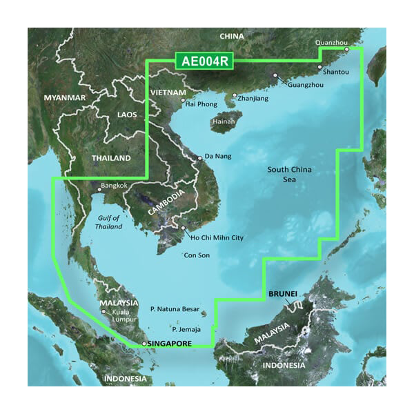
- High-Resolution Basemap includes detailed coastal imagery covering Thailand, Vietnam, Malaysia, Indonesia, Brunei, and China maritime zones
- New Chart Guarantee provides access to periodic chart updates reflecting regulatory changes, newly surveyed hazards, and seasonal navigation corrections issued by regional maritime authorities
- Dual-Format Compatibility supports both legacy microSD and modern SD card readers across Garmin's full marine product line, ensuring compatibility with older and newer vessel installations
Final Verdict
The Garmin VAE004R South China Sea Coastal Charts are essential for any serious mariner, commercial fishing operation, or charter service operating in the region. The combination of Auto Guidance route calculation, granular 1-foot contours, customizable depth shading, and 3D underwater visualization directly translates to safer passages, reduced navigation time, and measurably better fishing results. Invest in this precision chart solution and navigate the South China Sea with the detailed, reliable positioning data that prevents costly deviations and maximizes operational efficiency. Order your card today to gain immediate access to the most comprehensive charting coverage available for Southeast Asian coastal waters.


