


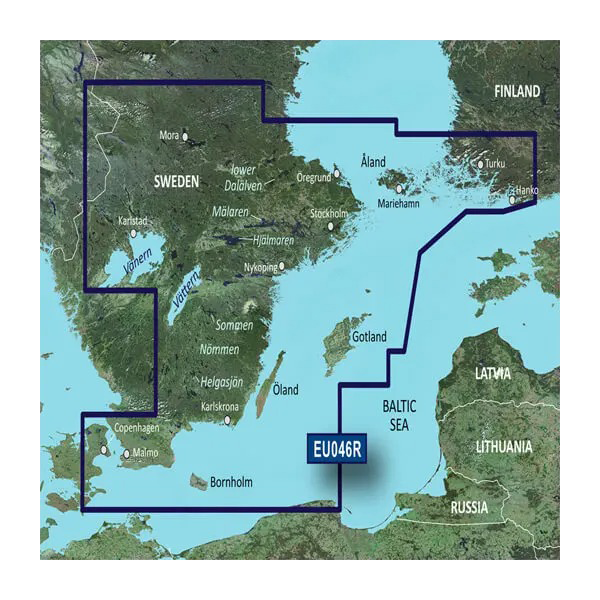
Garmin Sweden, Southeast Coastal and Inland Charts BlueChart g3 | HXEU046R | microSD/SD
Garmin Sweden, Southeast Coastal and Inland Charts BlueChart g3 | HXEU046R | microSD/SD
Model Number: 010-C0782-20
In stock
 View full details
 WhatsApp
 SMS - Text us!
 Email Us!
 Help Desk

Tech Specs
In The Box
Manual & Warranty
Do you have an old GPS unit lying around? The GPS Nation Trade In and Up program is a great way to trade in your old and used GPS for credit towards a new GPS. The choice is entirely yours! We’ve made the process simple and streamlined. Follow these simple steps, and you will be on your way to receiving credit towards your brand new GPS!
1. Get a quote
To get your free quote, provide your GPS type, manufacturer, model, and condition. Within 24 hours, you will receive a quote for the trade-in value of your current product. The GPS trade-in/trade-up form is at the bottom of this page.
2. Ship your product(s) for trade
After accepting our offer, pack your product(s) safely and ship them to us using the pre-paid shipping label provided to you. We will provide a confirmation email when your trade-in arrives at our warehouse. You have 30 days from the date you complete your on-line trade to ship the product to GPS Nation.
3. Make your purchase
Once we receive your product at our warehouse and we validate the stated condition, we will send you a confirmation email. If you elect to receive credit towards a new GPS at gpsnation.com, your store credit will be issued, and you are free to make your purchase.
Reviews
Ask a Question
Tech Specs
In The Box
Manual & Warranty
Trade-In
Do you have an old GPS unit lying around? The GPS Nation Trade In and Up program is a great way to trade in your old and used GPS for credit towards a new GPS. The choice is entirely yours! We’ve made the process simple and streamlined. Follow these simple steps, and you will be on your way to receiving credit towards your brand new GPS!
1. Get a quote
To get your free quote, provide your GPS type, manufacturer, model, and condition. Within 24 hours, you will receive a quote for the trade-in value of your current product. The GPS trade-in/trade-up form is at the bottom of this page.
2. Ship your product(s) for trade
After accepting our offer, pack your product(s) safely and ship them to us using the pre-paid shipping label provided to you. We will provide a confirmation email when your trade-in arrives at our warehouse. You have 30 days from the date you complete your on-line trade to ship the product to GPS Nation.
3. Make your purchase
Once we receive your product at our warehouse and we validate the stated condition, we will send you a confirmation email. If you elect to receive credit towards a new GPS at gpsnation.com, your store credit will be issued, and you are free to make your purchase.
Overview
Garmin Sweden, Southeast Coastal and Inland Charts BlueChart g3 | HXEU046R | microSD/SD
Introducing the Garmin BlueChart g3, the ultimate navigation tool for your aquatic adventures. Designed to enhance your experience on the water, this cutting-edge equipment combines industry-leading coverage with advanced technological features, ensuring safe and confident navigation. Whether you're fishing in your favorite spot or exploring new coastal areas, the BlueChart g3 provides unparalleled detail and clarity.
Key Features
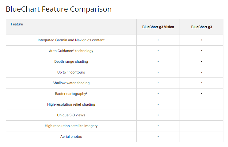
- Industry-Leading Coverage: Comprehensive coastal charts that integrate Garmin and Navionics content.
- Auto Guidance Technology: Automatically calculates suggested routes based on desired depth and overhead clearance.
- Depth Range Shading: Up to 10 depth ranges for easy identification of target depths.
- High-Resolution Contours: 1-foot contours offering precise depiction of underwater structures.
- Shallow Water Shading: User-defined shading to help avoid obstacles.
- High-Resolution Satellite Imagery: Realistic charting display overlaid on satellite images for unfamiliar areas.
- 3D View Perspectives: FishEye and MarinerEye views for detailed underwater and surrounding perspectives.
- Aerial Photography: Crystal-clear images of ports, harbors, and marinas for enhanced navigation.
Data Insights
With the Garmin BlueChart g3, users can experience up to 30% more detail in coastal areas compared to previous chart versions. The integration of Garmin and Navionics content ensures that the charts are not only comprehensive but also consistently updated, making it an essential tool for avid mariners.
Usage Instructions
To get the best results from your Garmin BlueChart g3, simply insert the microSD/SD card into your compatible Garmin chart plotter. Ensure your device is updated to the latest software to enjoy all features seamlessly. Utilize the Auto Guidance Technology for efficient route planning and make the most of high-resolution imaging to navigate confidently.
Design & Material
The Garmin BlueChart g3 features a sleek and functional design that fits perfectly into your marine navigation system. Its user-friendly interface ensures accessibility and ease of use.
- Durable Construction: Built to withstand marine environments.
- Compact Form Factor: Easy to store and transport.
- High-Quality Imaging: Enhanced visual clarity for superior navigation.
- Intuitive User Interface: Designed for effortless operation.
- Regular Updates: Frequent content updates to ensure accuracy and reliability.
- Wide Compatibility: Compatible with various Garmin devices for flexibility.
Final Verdict
The Garmin Sweden, Southeast Coastal and Inland Charts BlueChart g3 is an essential companion for anyone venturing out on the water. With its advanced features and detailed coverage, you will navigate with confidence and ease. Don’t miss out on this opportunity to enhance your maritime experience—get your Garmin BlueChart g3 today!


