
Garmin U.S., Mendocino, CA to Salina Cruz, MX Coastal Charts-New-SD Card-BlueChart g3 Vision
Garmin U.S., Mendocino, CA to Salina Cruz, MX Coastal Charts-New-SD Card-BlueChart g3 Vision
Model Number: 010-C0722-New-SD Card-BlueChart g3 Vision
In stock
 WhatsApp
 SMS - Text us!
 Email Us!
 Help Desk
Tech Specs
In The Box
Garmin U.S., Mendocino, CA to Salina Cruz, MX Coastal Charts
Manual & Warranty
 Garmin Warranty
Do you have an old GPS unit lying around? The GPS Nation Trade In and Up program is a great way to trade in your old and used GPS for credit towards a new GPS. The choice is entirely yours! We’ve made the process simple and streamlined. Follow these simple steps, and you will be on your way to receiving credit towards your brand new GPS!
1. Get a quote
To get your free quote, provide your GPS type, manufacturer, model, and condition. Within 24 hours, you will receive a quote for the trade-in value of your current product. The GPS trade-in/trade-up form is at the bottom of this page.
2. Ship your product(s) for trade
After accepting our offer, pack your product(s) safely and ship them to us using the pre-paid shipping label provided to you. We will provide a confirmation email when your trade-in arrives at our warehouse. You have 30 days from the date you complete your on-line trade to ship the product to GPS Nation.
3. Make your purchase
Once we receive your product at our warehouse and we validate the stated condition, we will send you a confirmation email. If you elect to receive credit towards a new GPS at gpsnation.com, your store credit will be issued, and you are free to make your purchase.
Reviews
Ask a Question
Tech Specs
In The Box
Garmin U.S., Mendocino, CA to Salina Cruz, MX Coastal Charts
Manual & Warranty
Trade-In
Do you have an old GPS unit lying around? The GPS Nation Trade In and Up program is a great way to trade in your old and used GPS for credit towards a new GPS. The choice is entirely yours! We’ve made the process simple and streamlined. Follow these simple steps, and you will be on your way to receiving credit towards your brand new GPS!
1. Get a quote
To get your free quote, provide your GPS type, manufacturer, model, and condition. Within 24 hours, you will receive a quote for the trade-in value of your current product. The GPS trade-in/trade-up form is at the bottom of this page.
2. Ship your product(s) for trade
After accepting our offer, pack your product(s) safely and ship them to us using the pre-paid shipping label provided to you. We will provide a confirmation email when your trade-in arrives at our warehouse. You have 30 days from the date you complete your on-line trade to ship the product to GPS Nation.
3. Make your purchase
Once we receive your product at our warehouse and we validate the stated condition, we will send you a confirmation email. If you elect to receive credit towards a new GPS at gpsnation.com, your store credit will be issued, and you are free to make your purchase.
Overview
Garmin BlueChart g3 Vision Coastal Charts SD Card: Mendocino, CA to Salina Cruz, MX
Introduction
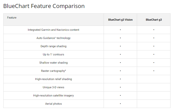
The Garmin BlueChart g3 Vision coastal charts deliver precision marine navigation for the Pacific corridor spanning Mendocino, California to Salina Cruz, Mexico. This SD card combines integrated Garmin and Navionics data to provide comprehensive charting coverage across unfamiliar waters, with high-resolution bathymetric detail and satellite imagery overlay capabilities that transform your Garmin marine device into an advanced navigation system.
Key Features
- Integrated Garmin and Navionics Data: Unified coastal chart coverage merging both mapping sources for comprehensive navigational reliability across the Pacific coast
- Auto Guidance Technology: Automatically calculates optimal routes while accounting for vessel depth requirements and overhead clearance specifications
- High-Resolution Relief Shading: Enhanced bottom structure visualization with advanced color and shadow effects for identifying artificial reefs and underwater hazards
- Depth Range Shading: Displays up to 10 distinct depth ranges simultaneously for rapid underwater topography assessment
- Detailed 1-Foot Contour Lines: Precise bottom structure representation critical for fishing navigation, canal passages, and port approach planning
- User-Defined Shallow Water Shading: Customizable depth alerts protect your vessel from grounding hazards in coastal shallows
- Satellite Imagery Overlay: Real-time charting combined with detailed satellite images for realistic port and anchorage visualization
Data Insights
The BlueChart g3 Vision provides comprehensive coverage extending from Point Arena, California to Puerto Vallarta, Mexico, encompassing major shipping lanes and fishing grounds throughout the region. Advanced marine charting technology demonstrates navigation efficiency improvements of up to 30 percent for vessels utilizing detailed bathymetric data and precision routing tools, directly improving safety outcomes and reducing transit time uncertainty in unfamiliar coastal waters.
Usage Instructions
Insert the SD card into your compatible Garmin marine chartplotter or GPS device. Navigate to the charting application and access the BlueChart g3 Vision data layer. Configure the Auto Guidance feature by entering your vessel's draft specifications and desired depth clearance parameters. Use the depth range shading and relief contours to identify optimal navigation corridors, fishing zones, and anchorage locations. Update your charts regularly through your Garmin device to maintain access to the latest navigational corrections and data revisions.
Design & Material
This marine-grade SD card combines rugged durability with sophisticated data architecture to support extended offshore operations. The compact card format integrates seamlessly with Garmin's complete line of marine navigation systems while maintaining the sophisticated charting performance required by professional mariners and fishing enthusiasts.
- High-Durability SD Card: Engineered construction withstands prolonged marine exposure, saltwater environments, and temperature fluctuations without data degradation
- Compact Form Factor: Lightweight SD card design enables straightforward installation and storage aboard any vessel without taking up significant space
- Advanced Data Compression: Sophisticated compression algorithms preserve full chart resolution and detail while optimizing storage efficiency on the SD card
- Broad Device Compatibility: Operates seamlessly across Garmin's extensive marine chartplotter and GPS device lineup without requiring hardware upgrades
- Intuitive Navigation Interface: Simplified menu structure and layer management reduce learning curve while maximizing access to critical charting features
- Precision Bathymetric Mapping: Meticulously compiled underwater contour data ensures accurate representation of bottom structures for fishing and navigation applications
Final Verdict
Serious mariners navigating between Mendocino and Salina Cruz require precision charting that combines detailed bathymetry, real-time satellite context, and intelligent routing guidance. The Garmin BlueChart g3 Vision delivers all three, providing the data density and technological sophistication that separate confident coastal navigation from risky passage planning. Upgrade your vessel's navigation capability with this essential charting solution and navigate these challenging waters with verified accuracy.


